Questions to be answered within a few weeks of logging or your logs will be deleted
Visit the two locations.
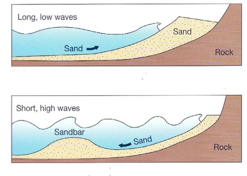
1-Does the Sandbar appear to be level on the top or does it vary in height?
2-What side is steaper?
3-Why do you think the one side is steeper? Explain how the waves/water motion would have played a part.
4-Do you think most of the material came from the lake? or from the hills to the East/West eroding down?
Lake Bonneville was a large fresh-water lake that occupied much of western Utah during the last ice age. At its maximum level, about 18,000 years ago, the lake was almost 1,200 feet deep and covered over 20,000 square miles. Waves and currents transported sediments along the shoreline of Lake Bonneville and created beaches, sandbars, and spits.
Normally sand is pushed up against a hillside or the edge of a mountain. That forces a sand bench to appear where the level of the water is. You see this prominanly in the area aound salt lake city, and the hills around the lake. The bathtub ring, or flat area that makes up the benches. They are locations where the lake sat at the same level for many hundreds of years.
The Stockton Bar formed as waves and currents brought sediments from the north and deposited them in the strait between South Mountain
(directly west of the town of Stockton) and the Oquirrh Mountains. The Stockton Bar is actually made up of several sandbars and spits built upon
one another as the level of the lake fluctuated. Each sandbar contains unique information about lake and climate conditions at the time it was
formed. Wave energy, current direc tion, wind speed, lake chemistry, and precipitation and evaporation levels are just a few of the environmental
conditions that can be interpreted from the Stockton Bar sediments.
The valley to the south was mostly a closed valley. Through most levels of the lake. So wind and waves that pushed the sand and gravel southward with the currents would drop those materials as it was unable to push far into the valley. Think of trying to push water up a bathtub. Eventually it had to come back. Yet that returning water slowed the forward motion causing the materials to drop out and form a sandbar. Over the rising of the lake this pushed this higher and higher. Until at the dropping of lake levels this would have been a lake or lagoon behind a natural dam. You can see one cut in the sandbar that was made by the railroad.
The deposits of the Stockton Bar are also unusual in that they contain a nearly continuous record of geologic history that spans several thousand years of Utah's last ice age (most other Bonneville deposits are discontinuous or only span a short interval of time). Few, if any, lakeshore bars can com pare to the Stockton Bar in terms of size and quality of preservation.
Information from the Geosights article,
Survey Notes, v. 33 no. 2, June 2001