Send your completed passport to:
Parks Canada—Geocache Series, 201 – 201 May Street North, Thunder Bay, Ontario, P7C 3P4
Bring your own pencil, as each cache is only large enough to contain a logbook (no trade items, please).
All geocaches are accessible directly from trails or public areas.
Cache may not be accessible in winter.
This cache is worth 10 points. It’s located in a provincial park. Please respect the park’s rules and regulations and pay fees.
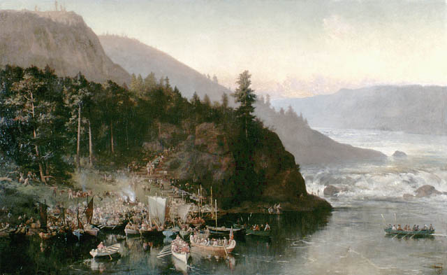
The Red River Expedition at Kakabeka Falls by Frances Anne Hopkins, 1877 (© Library and Archives Canada)
If you were a fur trader wanting to travel west across Canada in the 17th and 18th centuries, then Kaministiquia and Grand Portage were the two main routes to choose from.
This cache will take you to beautiful and historic Kakabeka Falls, where you can take in the spectacular view and ponder the evolution of place names.
An Ojibwe word meaning "(river) with islands", the Kaministiquia River, has quite a tongue twister of a name. Locals just call it the Kam River. If you pay attention to details you may notice there are a variety of different spellings of the river’s name. For example, the plaque contains an alternate spelling to the one used today, replacing the “qu” with a “kw”.
Historically, the river is first mentioned with the name “Kamanistigouian," in a decree dated August 23, 1681. Like the Pigeon River, this river was an important part of the water route into western Canada. During the French regime, a fur trading post was established at the mouth of the Kaministiquia, called Fort Kaministiquia, but it has also been spelled Kamanistigouian, Camanistigoyan, Kaministigoyan, etc. The river has had many spellings since 1681, finally being spelled as Kaministiquia, although at the time of the plaque casting Kaministikwia was also an official spelling.
FRANÇAIS
Le Cache-cache patrimoine série de géocaches est complètement différent d’un cours d’histoire ou géographie traditionnel. Préparez-vous à explorer le Nord de l’Ontario et à découvrir comment cette région a façonné le Canada que nous connaissons aujourd’hui. Trouvez les caches, répondez aux questions, obtenez au moins 100 points et vous pourriez vous mériter une géopièce du Cache-cache patrimoine à collectionner.
Envoyez votre passeport rempli à l’adresse suivante :
Parcs Canada – Série de géocaches, 201, rue May Nord, bureau 201, Thunder Bay (Ontario) P7C 3P4
Apportez votre propre crayon, car les caches peuvent uniquement contenir un registre (aucun article à échanger, s’il vous plaît).
Toutes les géocaches sont accessibles directement à partir des sentiers ou des aires publiques.
Les caches pourraient ne pas être accessibles en hiver.
Cette cache vaut 10 points. Elle est située dans un parc provincial. Veuillez respecter les règlements et payer les droits.
The Red River Expedition at Kakabeka Falls (l’expédition de la rivière Rouge aux chutes Kakabeka) par Frances Anne Hopkins, 1877 (© Bibliothèque et Archives Canada)
Aux XVIIe et XVIIIe siècles, les commerçants de fourrures qui voulaient se rendre dans l’Ouest du Canada devaient choisir entre deux routes principales : Kaministiquia et Grand Portage.
Cette cache vous mènera aux magnifiques et historiques chutes Kakabeka, où vous pourrez admirer la vue spectaculaire et songer à l’évolution des noms de lieux.
Mot ojibwe qui signifie « (rivière) qui compte des îles », le nom de la rivière Kaministiquia n’est pas facile à prononcer. Les gens de la région l’appellent simplement « rivière Kam ». Si vous portez une attention particulière aux détails, vous remarquerez peut-être qu’il existe plusieurs façons d’écrire le nom de la rivière. Par exemple, sur la plaque, on trouve Kaministikwia, plutôt que la graphie moderne Kaministiquia.
La rivière est mentionnée pour la première fois sous le nom « Kamanistigouian » dans un décret du 23 août 1681. Tout comme la rivière Pigeon, la Kaministiquia était une portion importante de la route navigable qui menait à l’Ouest canadien. Durant le Régime français, un poste de traite a été construit à l’embouchure de la rivière : Fort Kaministiquia, qui était aussi appelé Kamanistigouian, Camanistigoyan, Kaministigoyan, etc. De nombreuses façons d’écrire le nom de la rivière ont été utilisées depuis 1681, mais le nom actuel est Kaministiquia, même si la plaque présente la forme « Kaministikwia », qui était aussi une graphie officielle lorsque la plaque a été installée.