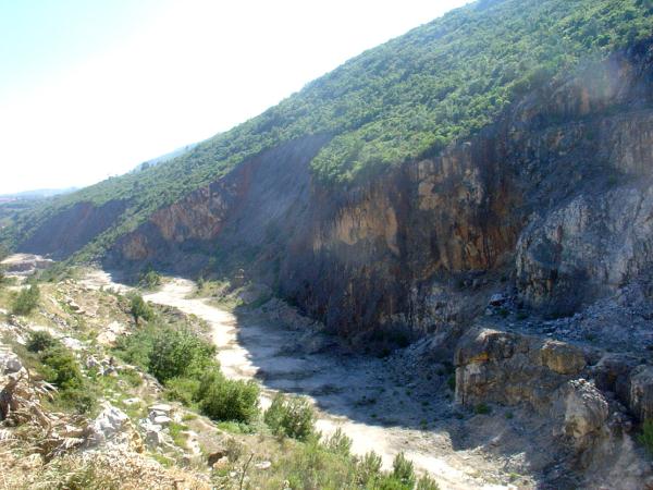
Magnifico mirror failure, where it is possible to clearly observe the striations resulting from the movement of the blocks. Both directions of existing stretch marks, indicate that there were several directions of movement at different times Failure brings together the rocks of Middle Jurassic (west) with the Upper Jurassic (this), separated by a narrow valley where it is located the "road" that connects the eye to couples Dagua of Alcobertas Monizes.
Also here the valley floor is covered by pelitic sediments of the Hettangian (Lower Jurassic base). A fault or failure is simply an area where a volume of rock observed relative displacement of the blocks extending parallel to fratura.
A failure varies between a few centimeters and several hundred kilometers. The fault plane is the surface where the fracture is observed relative displacement between blocks, the dimensions can vary widely.
A fault is caused by an accident tectonically fractured ground, along which there relative movement, more or less, of the two adjoining compartments. Flaws develop when the stresses (compressive, or shear distensivas) which are exerted on the rocks beyond the breaking point.
There are three main types of faults: normal faults - which are formed in extensional reverse faults environments - environments that form in compressive failure shutdown - who formed in environments tangential stresses is not common to find faults "pure" of this kind. Normally, either the normal faults, whether the reverse, have some component shutdown.
The fault splits two blocks, usually designated by raised block and block shot. The parts of the adjacent fault blocks are called the lips of failure. The plane that divides the two blocks is called the fault plane. Often the blocks to slide one another marking that drive the fault plane. These marks are called striae and are a good indication of the type of movement that occurred. Sometimes the fault plane, due to friction and temperature reached during the movement (ie, the game's fault), it is quite polished. Accordingly, it is customary to say that there is a smooth or mirror fault. When faults affecting masses of pyrite, the mirror enables even failure sometimes reflection image (almost like a mirror normal).
Failure is essentially characterized by the direction and inclination of the fault plane. Due to the fault movement occurred in two adjacent points previously (sayings homologous points) were kept away from certain distance. This distance is known as tailing failure. Often use is also reject the assignments horizontal (distance, horizontal, separating two homologous points), and reject vertical (distance vertically separating two homologous points). As is evident, the vector addition of two real tailings from the tailings. Sometimes the failure to play, ie the blocks by moving relative to each other, fracture into small pieces which lie between them, and that can later be aggregated by any type of cement (usually precipitated by the carbonate water). It is said, therefore, that there is a breach or failure of friction. Other times, the fault plane are clays, clays said failure or, in the terminology mining, "rubber"). The intersection of the fault with the topographic surface is called a trace of failure which often is not clear because there is that the soil and vegetation cover. However, often failures acquire very clear morphological expression, comes to constitute notable gaps. In these cases it is said that there is a slope failure. Normally, failures do not occur in isolation but fault systems. Most systems failures are associated with stress fields associated with the plate tectonics. Sometimes occur systems reverse faults generated by compressive tectonic environments, which causes the central length rises.
These are called horsts, which are common, for instance, in the border zones of converging plates when there continental collision. The horsts lead to a shortening of the crust, i.e. is a form of the material staying strong compressive stresses. Sometimes, there are systems of normal faults, generated by extensional environments, following the central compartment is slaughtered. Grabens are frequent, for example, in areas which are installed divergent plate boundaries, i.e. where the riftogénese occur. Before a strongly extensional environment, the materials accommodating in the direction of elongation of providing a crust.
In order to log this cache, you must answer the following questions:
1 - Measure the slope and say that the fault plane locally?
2 - What is the direction of the fault plane?
Responses should be sent by e-mail and not placed in the log. (Use our profile to send). If they do not log our confirmation, it will be deleted. Please log in to place a reference / name cache in Your responses.
Magnifico espelho de falha, onde é possivel observar claramente as estrias resultantes da movimentação dos blocos. As duas direcções de estrias existentes, indicam que houve diversas direcções de movimentação, em diferentes momentos A falha põe em contacto as rochas do Jurássico Médio ( a oeste) com as do Jurássico Superior (a este), separadas por um estreito vale onde se localiza a "estrada" que liga o Olho dÁgua de Alcobertas a Casais Monizes.
Também aqui o fundo do vale está coberto pelos sedimentos pelíticos do Hetangiano (base do Jurássico Inferior). Uma Falha geológica, ou simplesmente falha é uma superfície num volume de rocha onde se observa deslocamento relativo dos blocos paralelos à fratura.A extensão da falha varia entre poucos centímetros e centenas de quilómetros.
O plano de falha é a superfície da fractura onde se observa deslocamento relativo entre blocos, as dimensões podem variar de forma ampla. Uma falha é um acidente tectónico originado por fractura do terreno, ao longo da qual houve deslocamento relativo, maior ou menor, dos dois compartimentos contíguos. As falhas desenvolvem-se quando as tensões (compressivas, distensivas ou tangenciais) que se exercem nas rochas ultrapassam o ponto de ruptura. Existem três tipos principais de falhas: falhas normais - que se formam em ambientes distensivos falhas inversas - que se formam em ambientes compressivos falhas de desligamento - que se formam em ambientes de tensões tangenciais Não é comum encontrar falhas "puras" deste tipo. Normalmente, quer as falhas normais, quer as inversas, têm alguma componente de desligamento.
A falha divide dois blocos, designados normalmente por bloco levantado e bloco abatido. As partes dos blocos adjacentes à falha chamam-se os lábios da falha. O plano que divide os dois blocos tem o nome de plano de falha. Com frequência, os blocos ao deslizarem um pelo outro deixam marcas dessa movimentação no plano de falha. Essas marcas chamam-se estrias e são uma boa indicação do tipo de movimento que ocorreu.
Por vezes, o plano de falha, devido à fricção e à temperatura atingidas aquando da movimentação (isto é, ao jogo da falha), fica bastante polido. Nestas condições, é costume dizer-se que existe um liso ou espelho de falha. Quando as falhas afectam massas de pirite, o espelho de falha permite mesmo, por vezes, a reflexão da imagem (quase como um espelho normal). A falha é caracterizada essencialmente pela direcção e pela inclinação do plano de falha. Devido à movimentação ocorrida na falha, dois pontos previamente adjacentes (ditos pontos homólogos) ficaram afastados de determinada distância. Essa distância é designada por rejeito da falha.
É frequente utilizarem-se, também, as designações de rejeito horizontal (distância, na horizontal, que separa dois pontos homólogos), e rejeito vertical (distância, na vertical, que separa dois pontos homólogos). Como é evidente, a adição vectorial destes dois rejeitos dá o rejeito real.
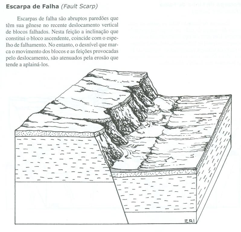
Por vezes, a falha ao jogar, isto é, os blocos ao deslocarem-se um relativamente ao outro, fracturam-se em pedaços pequenos que ficam entre eles, e que mais tarde podem ser agregados por qualquer tipo de cimento (frequentemente carbonato precipitado pela água). Diz-se, então, que existe uma brecha de falha ou de fricção. Outras vezes, no plano de falha existem argilas, ditas argilas de falha ou, na terminologia mineira, "borracha"). A intersecção da falha com a superfície topográfica designa-se por traço de falha, o qual, muitas vezes, não é evidente devido à existência de solo e vegetação que o cobrem. No entanto, muitas vezes, as falhas adquirem expressão morfológica muito evidente, chegando a constituir desníveis notáveis.
Nestes casos diz-se que existe uma escarpa de falha. Normalmente, as falhas não ocorrem isoladamente mas sim em sistemas de falhas. A maior parte dos sistemas de falhas estão associados a campos de tensões relacionados com a tectónica de placas. Por vezes ocorrem sistemas de falhas inversas, gerados por ambientes tectónicos compressivos, que fazem com que o comprimento central se eleve.
São os chamados horsts, que são frequentes, por exemplo, nas zonas de fronteira de placas convergentes, quando há colisão continental. Os horsts conduzem a um encurtamento da crusta, isto é, constitui uma forma dos materiais se acomodarem a tensões fortemente compressivas. Outras vezes, ocorrem sistemas de falhas normais, geradas por ambientes distensivos, na sequência do o compartimento central é abatido.
São os grabens, frequentes, por exemplo, nas zonas em que se estão a instalar fronteiras de placas divergentes, isto é, onde está a ocorrer riftogénese. Perante um ambiente fortemente distensivo, os materiais acomodam-se no sentido de proporcionarem um alongamento da crusta.

Para poder fazer o log desta cache, deverá responder ás seguintes perguntas:
1- Meça e diga qual a inclinação do plano da falha no local?
2- Qual a direcção do plano da falha?
As respostas deverão ser enviadas por e-mail e não colocadas no log.(Usem o nosso perfil para as enviar). Se fizerem o log sem a nossa confirmação, este será apagado. Por favor coloquem no log a referência/nome da cache nas Vossas respostas.
 The most exciting way to learn about the Earth and its processes is to get into the outdoors and experience it first-hand. Visiting an Earthcache is a great outdoor activity the whole family can enjoy. An Earthcache is a special place that people can visit to learn about a unique geoscience feature or aspect of our Earth. Earthcaches include a set of educational notes and the details about where to find the location (latitude and longitude). Visitors to Earthcaches can see how our planet has been shaped by geological processes, how we manage the resources and how scientists gather evidence to learn about the Earth. To find out more click HERE.