
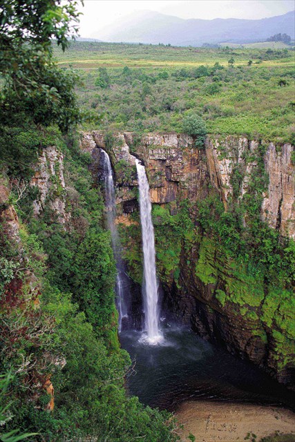
The Mac Mac Plunge
Background on Mac Mac Falls
The Mac Mac Falls at 65m on the Panorama Route in Mpumalanga, is second highest to the Lisbon Falls and was declared a National Heritage Site in 1983.
During the late 1860′s, gold diggers from around the world came to Mpumalanga in search of gold. The first major gold diggers camp (even before the gold rush to Pilgrim’s Rest) was situated at Mac Mac (halfway between Sabie and Graskop – just below the current Mac Mac Forest Retreat). The first gold commissioner in the area, Major MacDonald, was situated at this camp.
When the late President Burgers from the Zuid Afrikaanse Republiek heard of the amount of gold found, he decided to investigate. When he arrived, he was very surprised with the amount of Scottish people at the camp. He decided on the spot to call this place Mac Mac because of all the MacClaclans, MacDonalds, McFees, etc. It was from Mac Mac where the diggers explored and eventually found gold around Pilgrim’s Rest.
This waterfall was originally one single stream but the Mac Mac diggers created the second fall when they blasted it with dynamite to divert the river in an attempt to work the rich gold-bearing reef over which it plunges.
Cement steps with safety railings have been provided to gain access to the view points from where one can see the two uninterrupted cascades plunging into the deep densely wooded chasm, with the river twisting in the gorge below.
Geology
Although there is no certainty, geological evidence indicates that gold-bearing debris was exposed almost 2 500 000 years ago on mountains, and that it was carried by glaciers and rivers to a big inland sea. The gold that was washed away thus precipitated in consecutive layers of pebbles along the coast of the inland sea.
Over a period of millions of years this basin, which could have been about as big as the Caspian Sea, silted up. Climatic extremes in subsequent centuries warped and changed the soil surface. The gold remained in rock that today is sloping down from the surface of the earth to a depth of up to 7 600 m and more.
It has been generally considered that the mineralized zones containing gold are due to the intrusion of a granite batholith (Nelspruit Granite Suite) into sediments of the Transvaal System. This theory has been discounted somewhat in recent years. In a number of instances payable zones have been associated with igneous dykes and interbedded sills. It is possible that these dykes and sills were intro the area at much the same time as the Bushveld Igneous Complex some distance to the west. The intrusions created conditions favourable for the percolation of the mineralizing solutions and resulted in the formation of the interbedded reefs and leaders which formed along the planes of weakness. The reefs, for the most part, carry a high percentage of quartz and are oxidized near the surface becoming sulphidic with increased depth of cover.
The rock formations of the Drakensberg which form the Pilgrim's Rest gold fields have been well prospected. Due to this extensive exploratory work and the nature of the ore-bodies, it seems that the future depends more upon the economical working of the gold reefs in the known areas than on the discovery of new deposits.
Formation of waterfalls
Waterfalls are commonly formed when a river is young. At these times the channel is often narrow and deep. When the river courses over resistant bedrock, erosion happens slowly, while downstream the erosion occurs more rapidly. As the watercourse increases its velocity at the edge of the waterfall, it plucks material from the riverbed. Whirlpools created in the turbulence as well as sand and stones carried by the watercourse increase the erosion capacity. This causes the waterfall to carve deeper into the bed and to recede upstream. Often over time, the waterfall will recede back to form a canyon or gorge downstream as it recedes upstream, and it will carve deeper into the ridge above it. The rate of retreat for a waterfall can be as high as one and half meters per year.
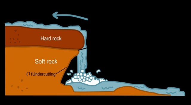
Often, the rock stratum just below the more resistant shelf will be of a softer type, meaning that undercutting due to splashback will occur here to form a shallow cave-like formation known as a rock shelter under and behind the waterfall. Eventually, the outcropping, more resistant cap rock will collapse under pressure to add blocks of rock to the base of the waterfall. These blocks of rock are then broken down into smaller boulders by attrition as they collide with each other, and they also erode the base of the waterfall by abrasion, creating a deep plunge pool or gorge.
Streams become wider and shallower just above waterfalls due to flowing over the rock shelf, and there is usually a deep area just below the waterfall because of the kinetic energy of the water hitting the bottom. Waterfalls normally form in a rocky area due to erosion. After a long period of being fully formed, the water falling off the ledge will retreat, causing a horizontal pit parallel to the waterfall wall. Eventually, as the pit grows deeper, the waterfall collapses to be replaced by a steeply sloping stretch of river bed. In addition to gradual processes such as erosion, earth movement caused by earthquakes or landslides or volcanoes can cause a differential in land heights which interfere with the natural course of a water flow, and result in waterfalls.
A river sometimes flows over a large step in the rocks that may have been formed by a fault line. Waterfalls can occur along the edge of a glacial trough, where a stream or river flowing into a glacier continues to flow into a valley after the glacier has receded or melted. The large waterfalls in Yosemite Valley are examples of this phenomenon, which is referred to as a hanging valley. Another reason hanging valleys may form is where two rivers join and one is flowing faster than the other. Waterfalls can be grouped into ten broad classes based on the average volume of water present on the fall (which depends on both the waterfall's average flow and its height) using a logarithmic scale.
Class 10 waterfalls include Niagara Falls, Paulo Afonso Falls and Khone Falls.
Classes of other well-known waterfalls include Victoria Falls and Kaieteur Falls (Class 9); Rhine Falls and Gullfoss (Class 8); Angel Falls and Dettifoss (Class 7); Yosemite Falls, Lower Yellowstone Falls and Umphang Thee Lor Sue Waterfall (Class 6); Sutherland Falls (Class 5).
Origins of gold deposits
Gold is found in auriferous veins or reefs and in rivers-alluvial gold. Through the processes of weathering, gold particles in the form of nuggets or flakes are washed down from their gold pockets to the streams and rivers. Because it is 7 times as heavy as sand, it sinks to the river bed.
The area that the gold comes from is called the original source and these sources usually consist of veins, mineralised zones in bedrock, as well as permanent placers or preserved placers that were formed in the past.
In the Pilgrim's Rest area, flat-bedded epigenetic gold reefs are hosted within and close to the upper contact of the Malmani Subgroup dolomites.
The reefs occur more especially in the Dolomite and Black Reef Series, and mostly as interbedded ore sheets.
Sources: Wikipedia
To Log this Earth Cache you need to do the following:
1. Answer the following questions:
a) What type of waterfall is the Mac Mac falls? Punchbowl, Plunge or Chute
b) To proof your visit, please provide a short description of the viewing platform and the view of the falls at GZ.
2. (Optional) Take a photo without or with a team member with your GPS in hand with the falls in the view. Please upload this on your log. This is the best way to describe your visit.
Please take note that there are an entrance fee at the gate of R 10.00 per vehicle.
NOTE: You may log your visit prior to approval, but e-mail submissions that do not meet the above criteria will be deleted.
HAPPY HUNTING!!

............................................
|
FTF Honours
|
|
............................................