DE:
Nachdem euch Little Venntrail No.1 von Roetgen nach Konzen zum Imgenbroicher Venn geführt hat, führt euch dieser 16km Wander-Multi nun in einem großen Bogen durch dieses und anliegende Hochmoore. Dann folgt ihr dem sich schlängelnden Eschbach bis zum Wesertal, bevor es zurück nach Roetgen geht.
Die Wanderung führt größtenteils über schmale Pfade und verwegene Wurzel- und Bretterwege. Im Gegensatz zu No.1 sind hier hohe und feste Schuhe nützlich, gerade weil die Bretterwege auch so einige morsche Stellen aufweisen. Dafür laden die weichen Wege zwischen km 1.5 und 4 des Tracks sogar zum barfußlaufen ein...
Für den Cache braucht ihr in jedem Fall das Bilderraster! Unterwegs müsst ihr an den Wegpunkten nur das jeweilige Bild dazu identifizieren und damit die fehlende Ziffer der Finalkoordinate ermitteln. Das wars - es muss nichts gerechnet werden, alle Wegpunkte sind vorher bekannt. Damit es aber nicht zu leicht wird, gibt es einige Bilder die ähnliches zeigen - guckt also genau hin welches es wirklich ist.
Für eine entspannte Wanderung solltet ihr euch den Track vorher herunterladen. Da jeder Little Venntrail, sofern einzeln gegangen, eine Streckenwanderung ist, braucht ihr entweder zwei Autos oder ihr benutzt den Bus (siehe Referenzpunkte). Da letzterer nur selten fährt (und abends nicht), empfielt es sich die Busfahrt an den Anfang der Wanderung zu legen.
Es kommt gelegentlich zu Sperrungen wegen Feuergefahr, bitte prüft vor der Wanderung hier ob Zugangsbeschränkungen existieren. Wenn dort der Text "Die Wege im Naturschutzgebiet sind nicht zugänglich" steht, bzw. vor Ort die rote Fahne gehisst wird, ist die Wanderstrecke nicht mehr machbar.
EN:
This long-distance hike of 16km leads you through the highmoor Imgenbroicher Venn and the adjacent highmoors, Then you will follow the meandering Eschbach creek to the valley of the Weser, and finally reach Roetgen. For a hike from Roetgen to the Imgenbroicher Venn, you can follow Little Venntrail No.1
You will walk on single trails, boardwalks as well as as muddy trails, and forest paths. In contrast to No.1, paved roads could be avoided most of the time. Sturdy waterresistant hiking shoes are recommended - but, depending on the time of the year, some paths can also be fun barefoot.
To find the cache, you will need the picture grid! At all QtA waypoints, you will be able to identify one picture which gives you a digit A...G of the final coordinate. No calculations are needed, and all waypoints are known beforehand. But look closely, there are several pictures showing similar objects...
You can even download the gpx-track beforehand. If you do not walk both Little Venntrails in one day, you will either need two cars or take the bus. Since they drive infrequent, it is recommended to do the bus ride at the beginning.
Sometimes access restrictions to the High Fens exists due to fire hazard. Please check here beforehand if such restrictions exist. If you see the text "Die Wege im Naturschutzgebiet sind nicht zugänglich" on the left, or if you see red flags flying at the edge of the High Fens areal, the hike is not possible.
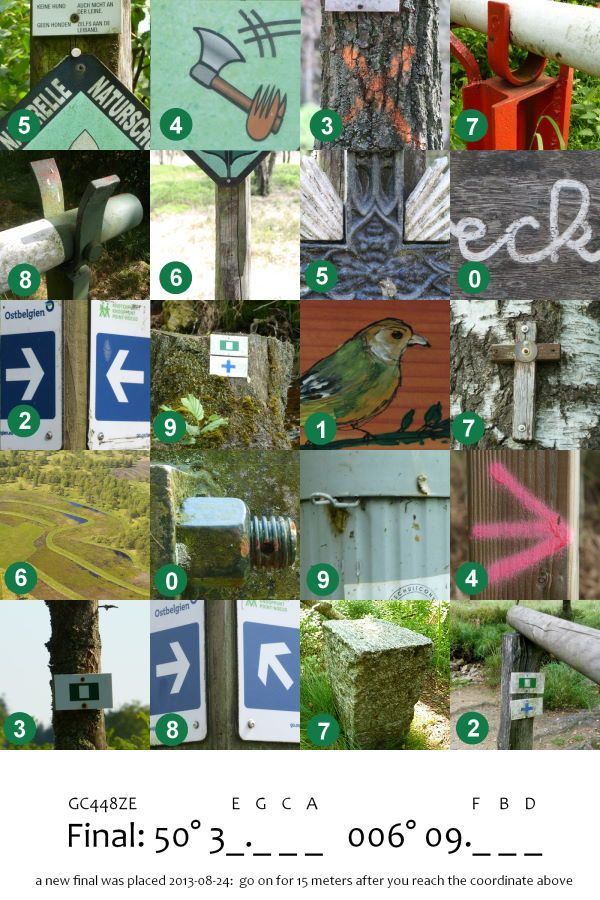
^^ Klick für großes Bild / Click for large image ^^
Viel Spaß! Enjoy!