
Português
POLJE: Extensa depressão aplanada resultante de grandes abatimentos de origem, em geral, tectónica. Durante a estação pluviosa é comum os poljes transformarem-se temporariamente em lagos, resultantes da subida do nível das águas que circulam em profundidade. Estas ascendem e voltam a infiltrar-se pelos chamados "sumidouros" ou "ponors".

Há 3 tipos de Poljes:
1. Secos Situados geralmente a maiores altitudes, em que a rede subterrânea se encontra muito abaixo da superfície. São os mais recentes.
2. Inundados temporariamente Quando a sua superfície evolui em profundidade e fica perto da zona piezométrica (zona em que a rocha se encontra saturada de água), por subida das águas subterrâneas o polje pode ficar inundado em certas alturas do ano. Do género “meia-idade”.
3. Inundados permanentemente Quando já evoluiu tanto em profundidade que a sua superfície se mantém sempre abaixo da superfície piezométrica. São os poljes senis.
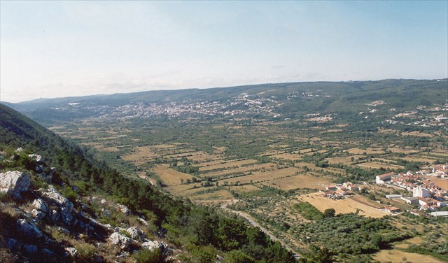
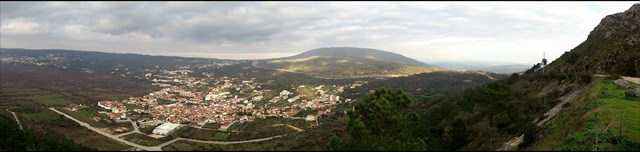
O POLJE de MIRA DE AIRE / MINDE, ou a "Mata", como vulgarmente é conhecida, é uma grande depressão cársica localizada entre as povoações de Mira d'Aire e Minde, que se inunda com alguma frequência durante os Invernos mais chuvosos. Trata-se de uma das mais interessantes formas da morfologia cársica em Portugal.
A escarpa ocidental desta depressão (Costa de Minde), é um excelente exemplo de escarpa de falha, do topo da qual se tem uma bela panorâmica de carácter paisagístico e geomorfológico.

Toda a região do Parque Natural das Serras de Aire e Candeeiros é essencialmente calcária, uma rocha muito fissurada que normalmente não consegue reter a água das chuvas. Mas como o subsolo, por debaixo do polje, é impermeabilizado, muito provavelmente devido a uma zona argilosa, sempre que chove bastante o nível da água sobe através dos próprios poços de água e inunda o vale. Este fenómeno não é sinónimo de satisfação para toda a gente. Alguns pastores queixam-se que a subida das águas lhes rouba o bom pasto para os animais, muito embora sejam mais tarde recompensados, pois, quando as águas baixam, grande parte da terra que esteve meses submersa torna-se no melhor pasto do vale. Mas quando a “cheia” é grande, aos fins-de-semana, com bom tempo, é ver uma autêntica romaria de turistas, para terem a sensação de que estão a admirar um belo lago suíço.
O “lago” ou “mar” de Mira de Aire-Minde gera toda uma fauna única. As gaivotas não se furtam a voar mais de 50 km da costa, para passarem alguns meses deliciadas a caçar, principalmente os famosos peixes-rã, ou girinos, que se alimentam dos pequenos insectos que proliferam naquele ambiente. Em Invernos de muita chuva chegam a ser milhões os peixes-rã e que se concentram ao longo das margens. Devido à abundância de alimento os maiores chegam a ter cerca de 10 cm, desde a cabeça até à ponta da cauda.
Além das gaivotas, este local é um bom observatório para outras aves, como os guarda-rios, os galeirões ou os patos bravos, que aproveitam as excelentes condições deste “habitat” e por aqui se fixam durante os meses em que há água em quantidade suficiente para se alimentarem. Mas para quem gosta de observar animais no seu meio natural, pode aproveitar para descobrir também répteis junto das margens: tritões, salamandras e cobras de água. Em anos de muita chuva o vale de Mira de Aire-Minde inunda-se, formando um enorme lago com oliveiras, castanheiros e carvalhos a sair das águas. Com uma profundidade máxima que chega a ser superior aos 15 metros na zona central, e perto das margens a rondar os quatro metros, reúne óptimas condições para o mergulho com botija. No pico do Verão, o falso lago desaparece, ficando reduzido a uns pequenos charcos. O mesmo local onde de Inverno até se faz canoagem, transforma-se, depois, numa pista de aterragem para parapente ou em percursos para btt.
Cache:
Para fazer o log tem que seguir os seguintes passos:
Dirigir-se ao Waypoint A e responder às seguintes perguntas:
1 - Que tipo de Polje se pode observar deste ponto?
2 - Qual o comprimento estimado do polje?
3 - Qual a largura estimado do polje?
4 - Qual a altitude que o vosso GPS indica.
5 - No log publiquem uma foto vossa com a paisagem do Polje por trás. (Facultativo)
Depois dirigir-se ao Waypoint B e responder às seguintes perguntas:
1 – Que tipo de flora predomina na escarpa ocidental desta depressão (Costa de Minde)?
2 – Que tipo de escarpa se pode verificar deste ponto?
Enviar as respostas para o meu Email para validar o log.

English
Polje: An extensive flattened depression resulting from a large soil setting, usually from a tectonic origin. During rainy periods it is very often for poljes to grow into temporarily lakes, as a result from the rising of the ground water levels. Later, they infiltrate into the so-called "sumidouros" or "ponors."
There are 3 types of Poljes:
1. Dry – Located generally at higher altitudes where the underground network is far below the surface. These are the most recent.
2. Temporarily flooded - When its surface develops underground and it stays close to the piezometric zone (area where the rock is highly water saturated), due to the groundwater rise, the polje may be flooded at certain times of the year. Like "middle age" type.
3. Permanently flooded - When it has evolved so much underground that its surface remains always below the piezometric surface. These are called “senile”Poljes.
The Polje MIRA DE AIRE / MINDE, or "Mata" as is commonly known, is a large karstic depression located between the villages of Mira d'Aire and Minde, and it is frequently flooded during the rainiest winters. This is one of the most interesting forms of the Portuguese Karstic morphology. The western scarp of this depression (Costa de Minde), is an excellent example of fault scarp, and from its top one can enjoy a beautiful landscape.
The entire region of Parque Natural de Serra de Aire and Candeeiros is essentially limestone, a very porous rock that does not retain rainwater. However, due to a layer of clay that is located beneath the polje, every time it rains, the water levels rises and floods the valley. Nevertheless, this is not a very pleasing phenomenon for everybody. Some herdsmen complain that the rising water takes the good pasture from their animals, although they become later rewarded, for when the waters infiltrate into the subsoil, much of the land that was submerged gives back the best pasture in the valley. But when there is a huge "flood", and during those good weather week-ends, one can see lots of tourists, that seek for that sensation similar to admiring a beautiful Swiss lake.
The Mira de Aire-Minde’s "lake" or "sea" generates a unique fauna. The seagulls do not bother to fly more than 50 km away from the shore, just to become delighted to spend a few months hunting, especially for the famous fish-frog, or tadpole, which feed on small insects that thrive in that type of environment. During rainy winters there concentrate several million frog and fish along the banks. Due to the abundance of food the biggest fish can get up to 10 cm from head to tail.
in addition to the sea gulls, this place is a good observatory to other birds, such as kingfishers, the coots or ducks, and they all enjoy this excellent habitat during the most abundant periods. But those who love to observe animals in their natural environment, can also take this opportunity to discover reptiles along the borders: newts, salamanders and water snakes. In those years of b precipitation the valley of Mira de Aire-Minde floods, forming a huge lake with olive trees, oaks and chestnut trees coming out of the water. This lake also provides excellent conditions for scuba diving, since it can reach a maximum depth higher than 15 meters in the central zone and 4 meters near the borders. At the peak of summer, this fake lake disappears and reduces into a few small ponds. And this same place where people could canoeing during the winter becomes then a runway for paragliding or several courses for mountain biking.
Cache: To log, you must complete the following steps: Go to waypoint A and answer the following questions:
1 – What type of polje do you see from this point?
2 - Please estimate the length of this polje?
3 - Please estimate how wide is this polje?
4 - What is the altitude indicated by your GPS?
5 – Please publish in you log a photo of you with the polje behind you. (Optional)
Then go to the Waypoint B and answer the following questions:
1 - What kind of flora predominates in the western escarpment of this depression (Minde Coast)?
2 - What kind of scarp can be seen from this point?
Send your answers to my email to validate your log.