Please follow the:

If you like this one you may want to try one or more of these
First some simple suggestions, definitions and rules
It can be useful to print the map and the worksheets
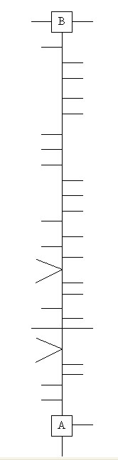
You will walk from point "A" to point "B", following the straight-line map below.
A straight-line map is a simplified drawing of how a mapped route would look if it was a piece of string that was then pulled straight, with all of the connecting paths still attached. The straight line represents the path(s) being traveled at all times (although the actual route will not look anything like the diagram). To the left or right of the central line are "branches". These are paths you should ignore. See examples of turns at the bottom of this description
A "Path" is defined as Blacktop, concrete, crushed limestone, wood chips, or wooden board walks. All segments of "the path" are constructed. The following are not considered part of "the path" - roadways, driveways, foot or deer paths.
An intersection for this cache is defined as where:
- Two or more paths (as defined above) meet .
- Access point to path meets the path
How to find the cache
- Go to the posted coords.
- There you will find white letters on a purple background.
- Count the number of letters in the word below Meadowlark
- The number of letters is "X" in the equation to find point "A" on the straight line map
- Point "A" is the middle of the closest intersection to the point your calculated
- At point "A" choose the only possible directions (orient the map to match what you are looking at).
- Follow the map to point "B"
- When you reach point "B" stop and you will be within 5 paces of the cache.
- Commence search for a hide-a-key container.
| X = ___ |
Point "A" |
| C = ___ (X) |
D = ___(X+3) |
E = ___(C+4) |
N 41 49. C D E |
W 088 08. F G H |
| F = ___(D-3) |
G = ___(E-2) |
H = ___(G+2) |
N 41 49.___ ___ ___ |
W 088 08.___ ___ ___ |
Examples Of How To Read Map

DuPage County Forest Preserve District: PERMIT # 286. 1. This cache is placed on the DuPage County Forest Preserve property with permission. 2. Do not place food, inappropriate, offensive or hazardous materials in container. 3. DuPage County Forest Preserve hours are 1 hour after sunrise until 1 hour after sunset. 4. It is your responsibility to be aware of the rules and regulations (see information kiosk) 5. All Forest Preserve rules and regulations apply.