Muuttuneet virrat, Kangasala EarthCache
Muuttuneet virrat, Kangasala
-
Difficulty:
-

-
Terrain:
-

Size:  (not chosen)
Please note Use of geocaching.com services is subject to the terms and conditions
in our disclaimer.
(FIN) Earthcache joka esittelee pohjoismaiden
suurimman luonnonmullistuksen tapahtumapaikkoja Kangasalla.
(ENG) Earthcache that introduces locations of
Nordic region's largest natural disaster event at Kangasala.
 tämä on Earthcache joten et löydä paikalta kätkölaatikkoa tai logikirjaa tähän kätköön liittyen. Tällä Eartcachella käynti osoitetaan suorittamalla kätkökuvauksessa kerrotut tehtävät. Eartcacheen eli maakätköön kuuluu oleellisena osana kohteen geologiaan liittyvä opetuksellisuus.
 This is an Earthcache so you won't find any items, box, physical cache or logbook at this site. you can log you visit by doing given tasks. Each EarthCache provides educational notes about current place geology.
 Muuttuneet virrat, Kangasala; GC42YW6

kostianvirta, Kostia Stream

Sarsanuoma, Sarsa Stream
Kangasalan muuttuneet virrat
(skip to English section.)
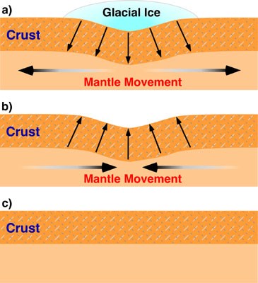
maankohoaminen
Maankohoaminen eli isostasia tarkoittaa maan hyvin hidasta kohoamista. Tämä johtuu Suomessa viimeisestä jääkaudesta, jolloin jäätikkö painoi maankuoren lommolleen. Jäätikön aiheuttama maankuoren lommolleen painuminen on havaittavissa nykyään Etelämantereen ja Grönlannin jäätiköistä. Kun jäätikkö on sulanut, lommo pyrkii hitaasti oikenemaan. Kun maa kohoaa vesistön rannan lähellä, kuivaa maata ilmestyy, saaret kasvavat ja merestä ilmestyy uusia saaria. Suomessa maan kohoaminen näkyy tällä hetkellä selvimmin muun muassa Vaasan seuduilla Merenkurkun rannoilla. Aikojen kuluessa maankohoaminen on myös muuttanut jopa vesistöjen virtaussuuntia.
Sarsanvirta boguspiste N 61° 26.910 E 024° 07.060
Sarsanvirta eli Sarsa Kangasalla on ollut aikoinaan Vesijärven ja Längelmäveden lasku-uoma Roineeseen. Sarsanvirran varrella, Huutijärvellä oli kivikaudella tärkeitä asuinpaikkoja.
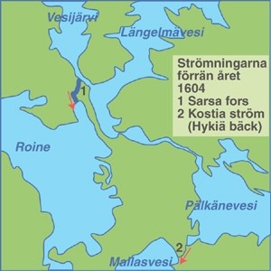
Sarsanvirran havaittiin kuivuneen 10. kesäkuuta 1604. Tapahtumat alkoivat Pälkäneveden ja Mallasveden välisen maakannaksen pettämisestä, jolloin paikalle syntyi Kostianvirta. Samassa yhteydessä Längelmäveden pinta aleni noin kolme metriä, Pälkäneveden vielä enemmän, ja Ihariin, näitä yhdistäneen entisen salmen paikalle muodostui Iharinkoski, jossa vesi virtasi nyt Längelmävedestä Pälkäneveteen.
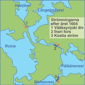
Runsaat sateet, maan kohoaminen ja ehkä myös Iharin patoaminen nostivat paineen järvissä yli sietokyvyn. Ensin petti maakannas Pälkäneveden ja Mallasveden välissä leventäen Hykiän puron leveäksi virraksi. Kun Pälkäneveden pinta aleni, paine Längelmävedessä käänsi Iharinkosken suunnan. Se alkoi virrata vesimassojen painosta kohti Pälkänevettä. Kun hyöky tasoittui, oli vedenpinta Längelmävedessä laskenut yli neljä metriä. Sarsa jäi ilman vettä. Veden laskusuunta oli pysyvästi muuttunut. Suuri, mutta matala virta kuihtui muutamaksi pieneksi lampareeksi. Järviä yhdistäneen Sarsan uoman paikalle jäi mitätön Vääksynjoki. GC42YW6, Vääksynjoki (Reference Point) N 61° 27.380 E 024° 07.080
Kangasalan virtojen tilannetta muutti edelleen Kaivannossa tapahtunut uusi vesien riistäytyminen. Kaivannon kanavan portit sortuivat ja alueen vesien virtaukset muuttuivat taas vuonna 1830, jolloin Längelmäveden pinta laski Roineen tasoon ja Iharinkoski kuivui. Kirjailija Sakari Pälsi on sijoittanut historiallisen romaaninsa Kova Mies ja Nimetön tapahtumat Sarsan maisemiin.

Iharinkoski GC42YW6, Iharin Kannas (Reference Point) N 61° 24.460 E 024° 15.195
Iharinkoski sijaitsi siis Pirkanmaalla Kangasalan kunnan Iharin kylässä 1604–1830. Aikaisemmin paikalla oli Längelmäveden ja Pälkäneveden yhdistänyt salmi. Vuonna 1604 Pälkänevedelle syntyi uusi lasku-uoma, Kostianvirta, ja järven vedet alkoivat virrata sitä pitkin Mallasveteen. Pälkäneveden pinta aleni tällöin nopeasti noin 3,5 metriä, Mallasveden tasolle. Myös Längelmäveden pinta laski, mutta vähemmän kuin Pälkäneveden, ja näitä järviä yhdistäneen salmen paikalle syntyi koski, jonka kautta Längelmävesi laski Pälkäneveteen. Samalla Sarsanvirta, jota pitkin Längelmävesi ja Pälkänevesi olivat laskeneet Roineeseen, kuivui 10. kesäkuuta 1604 yhdessä yössä. Siihen aikaan ajateltiin Iharinkosken olevan syyllinen Sarsan kuivumiseen ja syntyi sanonta "Ilkeä Iharin koski saatti Sarsan vaivaiseksi". Todellinen syyllinen Sarsan kuivumiseen oli siis Kostianvirta.
1800-luvun alussa alettiin rakentaa kanavaa Längelmäveden ja Roineen väliselle kapealle kannakselle. Keväällä 1830 rakentajien padot pettivät, ja syntyi Kaivannon kanava. Tällöin Längelmävesi laski Roineen tasolle ja Iharinkoski kuivui. Iharissa on nyt kannas, mutta suunnitelmissa on sen aukaiseminen veneliikenteelle ja vedenlaadun parantamiseksi lähivuosina. Keväällä 2012 Vaasan hallinto-oikeus antoi kannaksen avaushankkeelle myönteisen päätöksen.
kostianvirta GC42YW6, Kostian virta (Reference Point) N 61° 20.040 E 024° 16.305
Ennen vuotta 1604 nykyisen Kostianvirran kohdalla oli siis pieni Hykiänkoski, mutta pääosa Pälkäneveden, Vesijärven ja Längelmäveden vesistä laski Roineeseen Kangasalla sijainneen Sarsanvirran kautta. Toukokuussa 1604 vesi uursi Hykiänkosken paikalle suuremman uoman, ja Pälkäneveden pinta laski useita metrejä Mallasveden tasolle. Myös Längelmäveden pinta aleni, joskin vähemmän, ja se alkoi laskea entisen salmen paikalle syntyneen Iharinkosken kautta Pälkäneveteen.
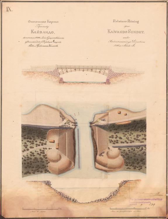
Kaivannon Kanava GC42YW6, Kaivannon kanava (Reference Point) N 61° 25.220 E 024° 08.510
Kaivannon kanava sijaitsee Kangasalla Längelmäveden ja Roineen välissä Vehoniemenharjun kohdalla. Aikaisemmin näiden järvien pinnat olivat eri tasossa, koska niitä erotti Kaivannon kannas. 1800-luvun alussa paikalle suunniteltiin rakennettavaksi kanava. Huhtikuussa 1830 Kaivantoon vasta valmistuneen kanavan rakenteet murtuivat. Kannas muuttui hetkessä avoimeksi kanavaksi, ja Längelmäveden pinta aleni noin kaksi metriä Roineen tasolle. Kanavan yli on nykyään Lahteen vievän valtatie 12:n silta ja paikalla on kioski. Kanavalla järjestetään talvisin mm. avantouimareiden uintitapahtumia, Kaivannon kanavan yliuinteja. Keväisin taas pidetään perinteinen kuoretapahtuma, jonka idea perustuu siihen, että kanavasta on pyydetty suurilla haaveilla (lipoilla) kutemaan nousevia kuoreita. Tämän kalastusmuodon huippukausi on lyhyt ja se ajoittuu aikaan jäidenlähdön ja koivun lehteentulon välillä.
Jotta voit merkitä logatuksi tämän kätkön sinun
täytyy suorittaa seuraavat tehtävät annetuissa koordinaateissa:
1 )
Mene Boguspisteen N 61° 26.910 E 024° 07.060 lähelle ja havainnoi sarsan uoman jäänteitä.
Mistä on havaittavissa että täällä on tapahtunut geologinen muutos?
Millaisia jäänteitä muinaisesta virrasta on havaittavissa?
arvioi muinaisen kosken mahdollinen leveys näillämain.
(huomioi että boguspisteen koordinaatit ovat melko summittaiset ja suuntaa antavat, vanhaa sarsankosken uomaa on havaittavissa tästä sekä pohjoiseen että etelään, kohden lähellä olevaa tradikätköä. Havintoja on siis hyvä tehdä laajemmalla alueella).
2 )
Mene pisteeseen (Reference Point) GC42YW6,
Vääksynjoki N 61° 27.380 E 024° 07.080 ja havainnoi Vääksynjokea.
kuinka leveä Vääksynjoki on kyseisellä paikalla?
Miksi vääksynjoki ei ole yhtä leveä kuin entinen sarsanuoma?
3 )
Mene pisteeseen (Reference Point) GC42YW6,
Kostian virta N 61° 20.040 E 024° 16.305 ja havainnoi kostianvirtaa.
Mikä on Kostianvirran leveys sillan kohdalla?
millaiseen maaperään uoma on kovertanut reittinsä?
4 )
Mene pisteeseen (Reference Point) GC42YW6,
Kaivannon kanava N 61° 25.220 E 024° 08.510 ja havainnoi kaivannon kanavaa.
Minkä geologisten muodostumien välissä kaivannon kanava sijaitsee?
Miten noiden muodostumien synty ja alueen maankohoaminen liittyvät toisiinsa?
vapaaehtoinen tehtävä:
Onko paikalla mitään jäänteitä kanavan sulkulaitteista?
5 )
Lähetä vastauksesi kätkön omistajalle vaikkapa tällä viestilinkillä.
Kirjoita viestin otsikoksi Muuttuneet virrat, Kangasala
(ps. jos valitset viestin alta "I want to send my email address along with this message" vastaamiseni helpottuu)
7 )
Sinun ei tarvitse odottaa loggauslupaa, mutta asiattomat logit tullaan poistamaan. Omistaja vastaa jollain aikavälillä viestiin, jos vastauksissa on epäselvää.
8 )
Toivottavaa on myös että otat valokuvan itsestäsi ja/tai gps laitteestasi pisteissä
Boguspiste N 61° 26.910 E 024° 07.060
(Reference Point) GC42YW6, Vääksynjoki N 61° 27.380 E 024° 07.080
(Reference Point) GC42YW6, Iharin Kannas N 61° 24.460 E 024° 15.195
(Reference Point) GC42YW6, Kostian virta N 61° 20.040 E 024° 16.305
(Reference Point) GC42YW6, Kaivannon kanava N 61° 25.220 E 024° 08.510
ja liität ne logiisi.
(Iharin Kannakseen liittyen ei ole loggaustehtävää, mutta paikkana se on vierailemisen arvoinen)
changed streams, Kangasala
Isostasy
Isostasy (Greek ísos "equal", stásis "standstill") is a term used in geology to refer to the state of gravitational equilibrium between the earth's lithosphere and asthenosphere such that the tectonic plates "float" at an elevation which depends on their thickness and density. This concept is invoked to explain how different topographic heights can exist at the Earth's surface. When a certain area of lithosphere reaches the state of isostasy, it is said to be in isostatic equilibrium. Isostasy is not a process that upsets equilibrium, but rather one which restores it (a negative feedback). It is generally accepted that the earth is a dynamic system that responds to loads in many different ways. However, isostasy provides an important 'view' of the processes that are happening in areas that are experiencing vertical movement. Certain areas (such as the Himalayas) are not in isostatic equilibrium, which has forced researchers to identify other reasons to explain their topographic heights (in the case of the Himalayas, which are still rising, by proposing that their elevation is being "propped-up" by the force of the impacting Indian plate).
In the simplest example, isostasy is the principle of buoyancy where an object immersed in a liquid is buoyed with a force equal to the weight of the displaced liquid. On a geological scale, isostasy can be observed where the Earth's strong lithosphere exerts stress on the weaker asthenosphere which, over geological time flows laterally such that the load of the lithosphere is accommodated by height adjustments.
When the ice retreated from Fennoscandia more than 10,000 years ago, the Earth's crust was depressed half a kilometre due to the weight of the ice which was 2 kilometres thick . When the ice melted, the crust began to rise, and the recovery still continues. This is called isostatic reboun. Near the Gulf of Bothnia, where the ice was thickest, the current uplift rate is about 2 centimetre per year, and there is still some 100 meters to rise. Geographically, the Gulf of Bothnia remained under the ice during Yoldiasea era. The Gulf of Finland was open but most of Finland was an archipelago, over which debris carried by glacial streams gradually spread. Relieved of its weight of ice, Finland rose gradually and unevenly from the sea. At the Course of time the land elevation has even changed water flow directions between great lakes.
Sarsa boguspoint N 61° 26.910 E 024° 07.060
Sarsanvirta or Sarsa Kangasala was once downward channel of Vesijärvi and Längelmävesi to lake Roine. Sarsanvirran at Huutijärvi was important Stone Age settlement.
Sarsanvirran was found drained of 10 June 1604. Events began whit failure of land bridge between Pälkäne water and Mallasvesi where Kostia stream was born . At the same time Längelmävesi surface was reduced by approximately three meters, Pälkänevesi even more. At Ihari where there was before a strait these events formed rapids called Iharinkoski, where the water flowed now from Längelmävesi to Pälkänevesi
Heavy rainfall, land elevation, and perhaps also damming of Ihari increased pressure in lakes beyond their carrying capacity. First, betrayed the land bridge between Pälkänevesi and Mallasvesi. When the water level fell at Pälkänevesi, the pressure from Längelmävesi turned waterflow direction at Ihari strait. It began to flow towards the weight of the water masses from Pälkänevesi. When the tidal wave leveled off, the water level of Längelmävesi has fallen by more than four meters. Sarsa was left without water. Water downward trend was permanently changed. Once great stream dried up lefting behind only few small ponds. At the site born small creek called Vääksynjoki. GC42YW6, Vääksy River (Reference Point) N 61 ° 27.380 E 024 ° 07.080
Iharinkoski GC42YW6, Iharin Kannas (Reference Point) N 61° 24.460 E 024° 15.195
So Iharinkoski was located in the municipality of Kangasalan in the village of Ihari from 1604 to 1830. Previously, there were strait connecting Längelmävesi and Pälkänevesi. In 1604 waterlevel of Pälkänevesi dropped after creation of a new channel, Kostianvirta, and the lake waters began to flow into it along to the Mallasvesi. Pälkänevesi water level then declined rapidly to about 3.5 meters, to Mallasvesi level. Also Längelmävesi levels decreased, but less than Pälkänevesi, and the Strait uniting these lakes at the site was created.
In the early 1800s they began to build the channel into narrow isthmus between Längelmävesi and Roine. In the spring of 1830 the builders dams failed and in the Kaivanto channel was born. In this case, Längelmävesi decreased to lake Roine level and Iharinkoski dried. At Ihari there is now the isthmus, but it is planned to build the opening of boat traffic and improve water quality in the coming years. In the spring of 2012, the Vaasa Administrative Court issued the project of isthmus opening approved.
Kostianvirta GC42YW6, Kostian virta (Reference Point) N 61° 20.040 E 024° 16.305
Prior to 1604 at the place where now is the Kostia stream there was a small Hykiänkoski, and the main of of the pälkänevesi, Vesijärvi and Längelmävesi waters fell to lake Roine through Sarsanvirta located at Kangasala. In May 1604 the water dug a larger riverbed at earlier Hykiänkoski’s place, and Pälkänevesi water level fell several meters to the level of Mallasvesi. Also Längelmävesi surface decreased, though less.
Kaivanto Channel GC42YW6, Kaivannon kanava (Reference Point) N 61° 25.220 E 024° 08.510
Channel of Kaivanto is located in Kangasala between Längelmävesi and Roine at Vehoniemenharju. Previously, these lakes were in different levels, because they were separated by isthmus. In the early 1800 site was designed to construct the channel. In April 1830 the excavation was just completed, when unluckily channel structures were broken. Isthmus became instantly open channel, and Längelmävesi surface was reduced by approximately two meters at lake Roine level.
To log this cache you must do following tasks in given coordinates:
1 )
Got near to the Boguspoint N 61° 26.910 E 024° 07.060 and look for the remainings of the sarsa stream.
What can be observed that there is a geological change occurred?
What kind of memories you can see about once great stream?
evaluate how wide the ancient stream could bossible has been at this site.
2 )
Go to the point (Reference Point) GC42YW6,
Vääksynjoki N 61° 27.380 E 024° 07.080 and look down to the Creek of Vääksy.
how wide is the current Vääksy Creek (or Vääksynjoki?)
Why Vääksy river is not as wide as the former sarsanuoma?
3 )
Go to the point (Reference Point) GC42YW6,
Kostian virta N 61° 20.040 E 024° 16.305 look down to the stream.
How wide is the stream in the site of the bridge?
what kind of soil bed this path has been carved?
4 )
Go to the point (Reference Point) GC42YW6,
Kaivannon kanava N 61° 25.220 E 024° 08.510 and look for the channel.
channel is located between two geolocical formations.
what formations are those?
how are the genesis of those formations and land elevation of the area related?
Optional task:
Is there any remnants of channel sealing devices?
5 )
Send your answers (for example via this message link) to the cache owner.
Title your post “muuttuneet virrat, Kangasala”
(ps. if you enable selection "I want to send my email address along with this message" it is easier for me to reply)
6 )
You don't have to wait for a logging permission, but any incomplete logs will be deleted. Cache owner will reply something for post if there is some faults in answers.
7 )
It is hoped that you take a photo of yourself and / or your GPS device at ..
Boguspoint N 61° 26.910 E 024° 07.060
(Reference Point) GC42YW6, Vääksynjoki N 61° 27.380 E 024° 07.080
(Reference Point) GC42YW6, Iharin Kannas N 61° 24.460 E 024° 15.195
(Reference Point) GC42YW6, Kostian virta N 61° 20.040 E 024° 16.305
(Reference Point) GC42YW6, Kaivannon kanava N 61° 25.220 E 024° 08.510
and then paste them to your log.
(there is no logging task related to Ihari isthmus, but place itself is worth visiting)
 kuvien käännökset, pics translations:
glacial ice
mannerjää
crust
maan kuori
mantle movement
vaipan liike
Strömningarna förran året 1604
virrat ennen vuotta 1604
streams before year 1604
Strömningarna efter året 1604
virrat vuoden 1604 jälkeen
streams after year 1604
Strömningarna efter året 1830
virrat vuoden 1830 jälkeen
streams after year 1830
sarsa fors
sarsan koski
sarsa rapids
kostia ström (hykiä back)
kostian virta (Hykiän puro)
Kostia Stream (Hykiä Creek)
kaivanto kanal
kaivannon kanava
Kaivanto Channel
vääksynjoki älv
Vääksynjoki
Vääksy Creek
Ihari fors
Iharin koski
Ihari rapids
Kangasala, Oksalla ylimmällä,
on a branch at the top
In the past the nobility discovered Kangasala in the midst of the country of blue lakes and sunny ridges when they needed a refreshing change in their lives. Kangasala has also offered inspiration for many significant national artists through the years.
Tämä earthcache sarja on omistettu Kangasalan luonnolle
This earthcache series is dedicated to the praise the Beautiful Nature of Kangasala
Kangasalan earthcachet :
 Pallograniitti ja verikivi, Kangasala, GC3R3NK
Haralanharju, Kangasala, GC42TY4
Muuttuneet virrat, Kangasala, GC42YW6
- Maitomies -
you can also contact cache owner via facebook:

Additional Hints
(No hints available.)