(English) (Fotografije / Photos) (Konec teksta / End of Text)
Kazalo
1. Uvod
2. Splošno o tektonskih oknih
3. Geološka obdobja
4. Tektonske značilnosti Pivške kotline
5. Tektonsko okno pri Knežaku
6. Dostop
7. Zemeljski zaklad
8. Viri
9. Fotografije
Uvod
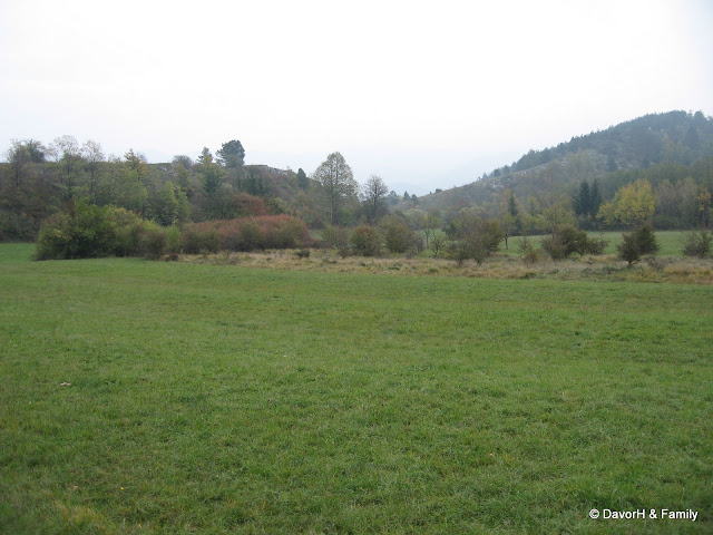
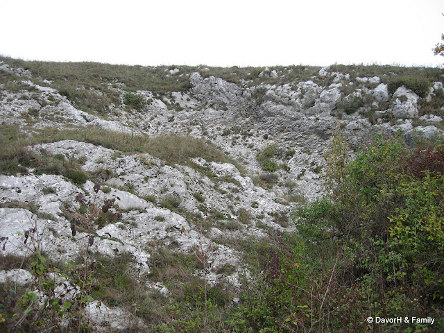
Tektonsko okno imenujemo območje, kjer sredi neke kamnine pride na površje druga kamnina. Pri Knežaku so se zaradi narivanja Snežniške planote na Brkine zemeljske plasti upognile in prevrnile, tako so starejše kamnine (apnenec) prišle nad mlajše (fliš). Z delovanjem zunanjih sil (voda, veter), je bil v Selu, kjer je bila plast apnenca najtanjša, ta odnešen in na površju se je pojavil mlajši fliš. Ta je rjave barve in je za vodo neprepustna kamnina. Sestavljajo ga gline, laporji, peščenjaki in apnenčeva breča. Fliš je precej mehkejši od apnenca, zato je takšno površje zelo razbrazdano.
Splošno o tektonskih oknih
Tektonsko okno (angl.: window, nemško: Fenster) je geološka struktura, ki nastane zaradi erozije ali prelamljanja na narivnih sistemih. V takšnem sistemu narivno plast (»visečo plast«), ki se premika z gibanjem ob prelomu, imenujemo krovna plast ali pokrov (nappe). Ko erozija ali prelamljanje naredita odprtino v pokrovu, skozi katero se pokaže osnovna oz. avtohtona plast (tista, ki se ne premika), tako odprtino imenujemo tektonsko okno.
Tektonska okna so lahko skoraj vseh velikosti, od nekaj metrov do več sto kilometrov.
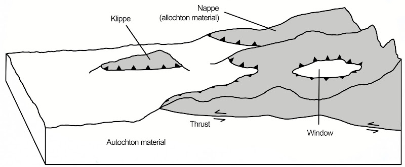
Narivni sistemi in tektonska okna
Geološka obdobja
Razumevanje geologije Pivške kotline in procesa nastanka tektonskega okna pri Knežaku, ki ju opisujemo v nadaljevanju, bo olajšala shema geoloških obdobij, prikazana na naslednji sliki. Obstaja več različnih klasifikacij in poimenovanj obdobij, slika v nadaljevanju prikazuje tisto, ki je trenutno najširše sprejeta. Prikazana je nekoliko skrajšana verzija, bolj celovit prikaz geoloških obdobij si lahko ogledate tukaj.
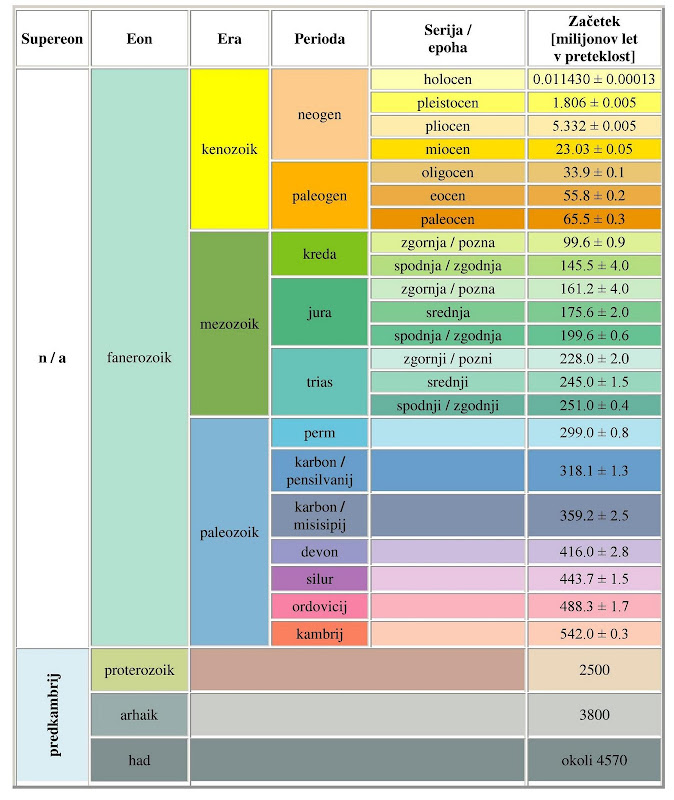
Geološka časovna preglednica
Tektonske značilnosti Pivške kotline
Čez Pivško kotlino poteka pomemben regionalni nariv, nariv Snežnika, ki loči Snežniško narivno grudo od Komenske narivne grude. Tektonsko okno pri Knežaku je dokaz starejših narivnih deformacij. Pokrajina je prerezana s številnimi mlajšimi prelomi, od katerih so najpomembnejši Raški, Predjamski in Selški prelom. Pokrajina Zgornje Pivke je tektonsko precej aktivna, kar kažejo potresi v zadnjih letih. Kot najbolj potencialni aktivni prelom se kaže Raški prelom oziroma kakšen od spremljajočih prelomov severno od Raškega preloma, npr. Šembijski prelom in morda tudi Selški prelom. Kraška presihajoča jezera Zgornje Pivke so razvita v zgornjekrednih apnencih in so od nariva Snežnika oddaljena 0,5-4 km proti SV. Večina jezer je oblikovana ob Selškem prelomu.
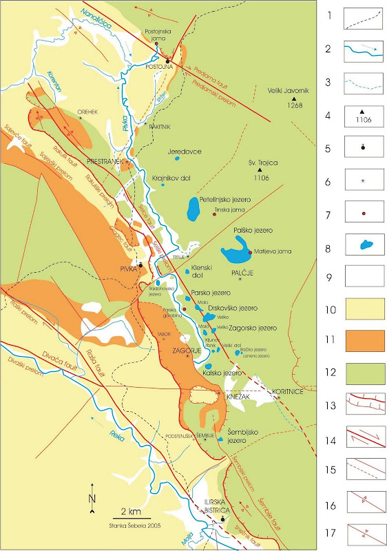
Geološka karta Pivške kotline s presihajočimi jezeri (sestavila S. Šebela)
Legenda: 1-železnica, 2-reka s smerjo toka, 3-občasni tok vode, 4-hrib z nadmorsko višino, 5-mesto, 6-manjši kraj, 7-kraška jama, 8-presihajoče jezero, 9-aluvij (kvartar), 10-fliš (eocen), 11-apnenec (paleogen), 12-prevladujoči apnenec (kreda), 13- nariv: močnejši in šibkejši, 14-desni zmik ob horizontalnem prelomu, 15-prelom: ugotovljen in pokrit, 16-antiklinala, 17- sinklinala.
Pivška kotlina je izredno zanimiva ne samo zaradi kraških presihajočih jezer ter kraške hidrologije, ampak tudi zaradi zanimive geološke zgradbe. V tem delu poteka pomemben regionalni nariv, imenovan nariv Snežnika, ki med seboj loči dve pomembni tektonski enoti. Severnejša Snežniška narivna gruda je narinjena na Komensko narivno grudo. Omenjeni nariv lahko sledimo nekoliko južno od Gemone v Italiji, čez Vipavsko dolino, kot nariv Snežnika ter SV od Reke na Hrvaškem, to je na dolžini vsaj 160 km. Za Pivško kotlino in področje Snežnika je značilna zmerna tektonska aktivnost, ki se kaže v zgodovinskih in sodobnih potresih. Geoloških in kraških zanimivosti v Pivški kotlini torej ne manjka.
Večina ozemlja današnje Slovenije pripada Jadranski mikroplošči. Alpska veriga je rezultat konvergence med Afriško in Evrazijsko ploščo. Jadranska mikroplošča je v veliki meri podrinjena pod Jadransko morje in prekrita z debelo plastjo mladih nesprijetih sedimentov, kot je primer v Padski nižini. Geološke in seizmične raziskave dokazujejo veliko verjetnost, da se V, Z in S robovi Jadranske mikroplošče podrivajo in ustvarjajo predgorje okoliškim deformiranim conam. Jadranska mikroplošča se verjetno počasi premika glede na sosednjo Evrazijsko ploščo. Glavni izdanek Jadranske mikroplošče je Istrski polotok Slovenije in Hrvaške. Na podlagi GPS meritev opazujemo v zahodni Sloveniji očitne in ostre (nekaj mm/ leto) desne premike vzdolž Savskega preloma in Periadriatske prelomne cone, kar nakazuje, da je bočno izrivanje v SV Alpah še vedno aktivno, saj ga povzroča rotacija Jadranske mikroplošče v nasprotni smeri urinega kazalca.
Poleg starejših narivnih prelomov (narivanje v miocenu) zasledimo tudi mlajše neotektonske prelome. Med njimi sta najpomembnejša Predjamski in Raški prelom, ki oba kažeta značilnosti desnega zmika. Za Pivško kotlino je pomemben tudi Selški prelom, ki se iz Prestranškega ravnika nadaljuje proti JV vse do Koritnic in domnevno še naprej proti JV v zahodno pobočje Snežnika. Večina presihajočih Pivških jezer se nahaja v območju (širine 1,5 km) Selškega preloma.
Na raziskanem terenu so najstarejše kamnine dobro plastnati apnenci ter dolomitne in apnene breče (spodnja do zgornja kreda), ki jih najdemo na območju Bača, Koritnic in V od Ilirske Bistrice. Sledijo zgornjekredni apnenci, ki gradijo Javornike. Med Snežniškim prelomom in Ilirsko Bistrico najdemo vremske plasti, ki jih uvrščajo v kredo in paleogen. Iz obdobja eocena imamo flišne laporje, peščenjake in numulitne breče. Dno Pivške kotline je deloma pokrito z rečnimi sedimenti. Usedline prekrivajo tudi dna največjih kraških depresij-presihajočih jezer. Presihajoča jezera Pivške kotline so razvita v zgornje krednih apnencih.
Tektonsko okno pri Knežaku
Z geologijo področja okrog Knežaka se je v okviru geologije t.i. reške flišne kadunje v svoji razpravi o eocenskih območjih na Notranjskem in v Istri že v 19. stoletju ukvarjal geolog Guido Stache. Trdil je, da je vzhodni (severovzhodni) rob kadunje prevrnjen in zapognjen proti jugozahodu. Na tem robu najdemo deloma med krednimi in flišnimi eocenskimi plastmi še eocenske apnence, deloma pa se kredne plasti stikajo s flišem brez vmesnih eocenskih apnencev. To kaže tudi, da so se kredne plasti delno narinile na fliš. Nekateri geologi so sicer izrazili dvom, da gre pri Ilirski Bistrici res za nariv krednih apnencev na eocenski fliš. Strma apnena stopnja, ki naj bi pri Ilirski Bistrici še predstavljala čelo nariva, se podaljšuje proti jugovzhodu mimo Reke in Bakra. Tam je ugotovljeno, da predstavlja strma stopnja samo vertikalni premik ob prelomu. Na severovzhodnem podaljšku, in sicer med Pivko in Postojno, stopnja polagoma izginja in plasti preidejo v normalno lego. Kredne plasti vpadajo pod eocenske apnence in ti pod fliš.
Že Stache je jugozahodno od Knežaka, ki leži na apneni stopnji, opazil večjo krpo fliša, ki jo pas eocenskega apnenca loči od reške flišne kadunje. Menil je, da je ta fliš pod stratigrafsko starejšim apnencem v zvezi s flišno kadunjo. Potemtakem je posredno zagovarjal mnenje, da gre za tektonsko okno. Slovenski geolog Mario Pleničar je leta 1958 geološko kartiral okoli Knežaka in po podrobnem ogledu terena potrdil Stachejeve trditve.
Da bi lažje razumeli tektonske razmere, moramo poznati normalni prehod krednih apnencev v eocenske apnence in le-teh dalje v fliš na obrobju reške kadunje. Tako normalno lego plasti vidimo skoraj na celotnem jugozahodnem obrobju reške kadunje. Tam leže spodaj debelokristalast temen bituminozni kredni dolomit in dolomitna breča, na njej sivi in beli radiolitni apnenci turonske in senonske stopnje, še više paleocenski miliolidni in kozinski haracejski apnenci ter na njih alveolinski in numulitni apnenci. Slednji postajajo navzgor vedno bolj lapornati ter tako preidejo zvezno in brez jasne meje v flišni eocenski lapor, v katerem se prično pojavljati še više pole apnenega in kremenovega peščenjaka. Plasti, v katerih opazujemo zvezen prehod numulitnih apnencev v flišne laporje, so debele 5 – 10 m.
Pri Knežaku tudi lahko opazimo vse prej naštete plasti, le v obratni legi. To kaže, da so se zemeljske plasti na tem področju nekoč v preteklosti prevrnile.
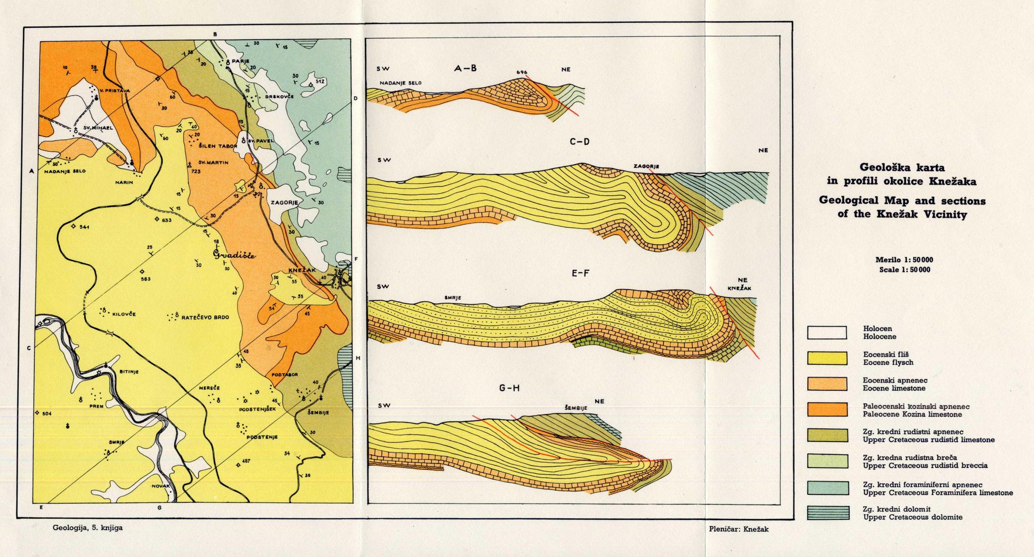
Geološka karta in profili okolice Knežaka
Geološka preseka C – D in E – F nam kažeta te razmere in jih obenem pojasnjujeta z zavihanim robom eocenske kadunje, ki je nastal zaradi narivanja krednih plasti Snežnika proti jugozahodu. Zavihan rob tvori prevrnjeno gubo. Ta guba na skrajnem severozahodnem delu karte pri Veliki Pristavi še ne vključuje flišnih plasti (glej presek A – B). Od Šilen Tabora do Podtabora se fliš že vključuje v gubo, se zajeda vanjo v globino okoli 2000 m in na dveh mestih pogleda na dan skozi raztrgano krilo prevrnjene gube izpod numulitnega apnenca v obliki tektonskih oken. Pri Podtaboru je pritisk krednih plasti pretrgal prevrnjeno gubo in kredni masiv je prodrl do flišne kadunje. Rob z eocenskimi in paleocenskimi apnenci je ostal pod narinjenimi krednimi plastmi (glej presek G – H).
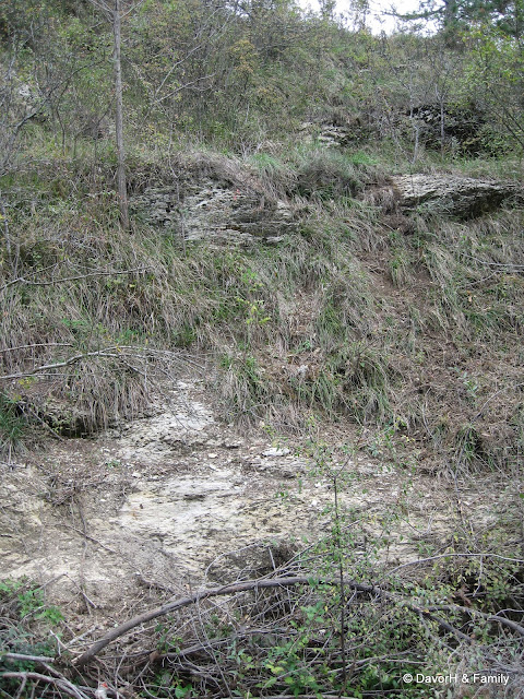
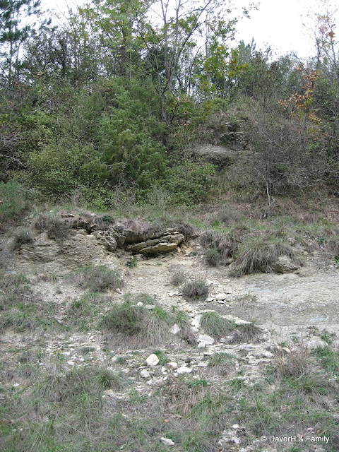
Pri vaseh Knežak in Zagorje sta sredi močno zakraselega apnenca dve krpi rodovitnega fliša. Posebno lepo lahko proučujemo geološke razmere v krpi pri Knežaku. Fliš vpada na vsem obrobju krpe pod apnene plasti, ki tvorijo obenem strmo stopnjo. Tektonsko okno je torej nastalo zaradi antiklinalnega vzbočenja fliša pri upognitvi roba flišne kadunje nazaj proti jugozahodu. Flišne plasti, ki se kažejo v tektonskem oknu, so torej prevrnjene, kakor tudi vse apnene plasti na stopnji od krednih do eocenskih. Podobne razmere so tudi pri Zagorju, le da je tam obrobje fliša bolj prekrito s preperino in geološke razmere niso tako očitne kot pri Knežaku.
Dokaz za to, da gre res za nariv, najdemo v obliki narivnega roba. Kjerkoli je namreč vrezana v ta rob hudourniška grapa ali potočna dolina, ki poteka pravokotno na narivni rob, sega v njej fliš daleč navzgor proti severovzhodu. Fliš leži torej pod apnencem. Če bi ležal apnenec pod flišem, bi imeli obratno sliko. Erozijske doline bi bile izdolbene v apnencu.
Prevrnjena guba in nariv apnenca na fliš pa imata tudi zanimive hidrološke posledice. Verjetno je ravno v takih tektonskih razmerah vzrok, da izvira na tem območju reka Pivka in da teče proti severu in ne proti jugu. Dokler niso bili zajeti za vodovod in v druge namene, je nekaj vode pritekalo v Pivko iz številnih studencev, ki izvirajo v flišu obeh tektonskih oken. Glavni dotok vode v Pivko, ki ima prvi izvir pri Zagorju, drugi pa v Parjah, pa prihaja od severovzhoda, to je s snežniškega območja. Če ne bi bilo flišne zapore, ki je nastala pri gubanju in narivanju, bi voda v celoti odtekala v reško flišno kadunjo, podobno kot deloma uhaja v izviru Bistrice v Ilirski Bistrici in morda ob prelomu v izviru v Podstenjšku. Tako pa se večji del s Snežnika prihajajoče vode odbije od flišne zapreke in teče od Zagorja in Parij mimo Radohove vasi in Petelinja proti Postojni. Ta del vode se torej že razmeroma blizu Reškega zaliva iztrga jadranskemu povodju in se priključi črnomorskemu. Če upoštevamo, da sega ves ta vodni horizont skoraj tik do roba 50 – 70 m visoke apnene stopnje in 130 – 150 m nad dolino reke Reke, je pomembnost zaporne flišne bariere, ki jo je povzročila tektonika, še toliko bolj očitna.
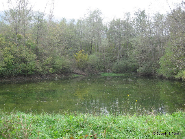
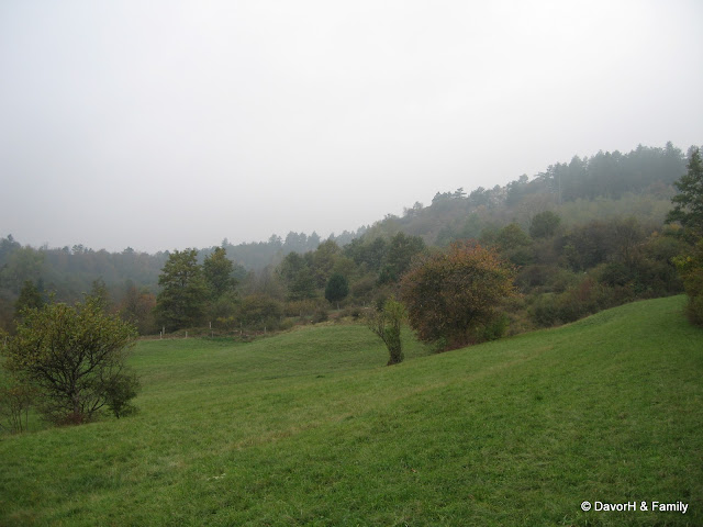
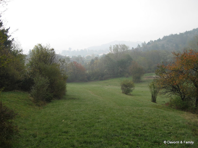
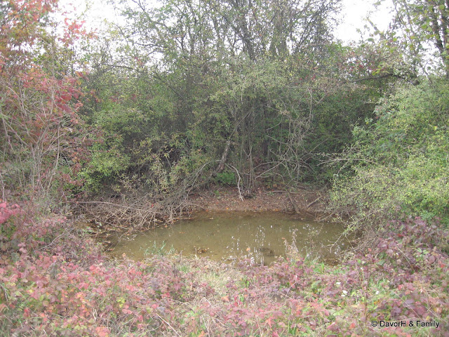
V tektonskem oknu je na flišu nastala prst, ki je temno rjave barve. Plast prsti je debela približno 25 cm, prst pa je srednje rodovitna in srednje zrnata. Nekoč je bilo v Selu, kakor domačini imenujejo področje tektonskega okna, 48 izvirov in je bilo precej mokrotno. To je posledica dejstva, da je fliš za vodo nepropusten, zato voda tam ne more ponikniti, pač pa ostaja na površju. Veliko je bilo njiv in travnikov ter lokev za napajanje živine. Danes je tukaj manj močvirij in površje je veliko bolj suho, tudi zato, ker so veliko izvirov zajeli in jih izkoriščajo za pridobivanje pitne vode. Kljub temu pa je zaradi drugih vzrokov manj travnikov, njiv pa sploh ni več. Veliko zemljišč se zarašča. Propadle so tudi lokve za napajanje živine. Eno so pred nekaj leti preuredili za rekreativne namene.
Dostop
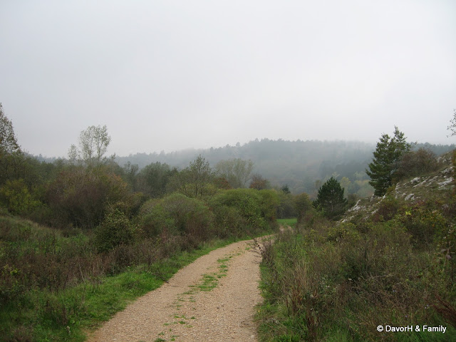
Do tega zemeljskega zaklada pridete iz Postojne, od koder greste v smeri Ilirske Bistrice oziroma Reke na Hrvaškem. Cesta vas po nekaj kilometrih pripelje do naselja Pivka, kjer v centru ne zavijete desno po prednostni cesti, ampak greste naravnost v smeri Knežaka. Druga možnost je pot iz Ilirske Bistrice v smeri Šembij in Knežaka.
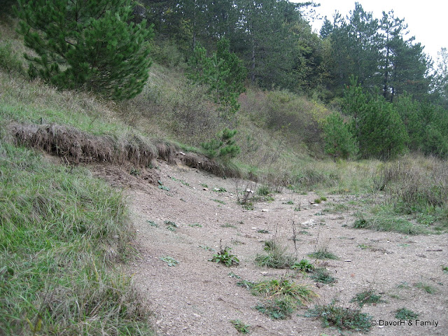
Tektonsko okno je blizu glavne ceste, do njega pa vodi kolovozna pot. Priporočamo, da avto pustite na parkirišču pri bencinski črpalki v vasi (točka PARK1) in se potem sprehodite nekaj sto metrov do zemeljskega zaklada. Glavno cesto zapustite pri točki TURN, kjer se usmerite proti zahodu na kolovozno pot. V kolikor bi si radi prihranili nekaj hoje, lahko pri točki TURN z avtom zavijete z glavne ceste in se po kolovozu odpeljete do točke PARK2, od tam naprej pa si pokrajino ogledate peš.
Dostop do zaklada je možen skozi celo leto, saj glavno cesto skozi Knežak plužijo, vendar pa obisk v času, ko zemljo prekriva snežna odeja, ni smiseln, saj boste takrat težko odgovorili na zastavljena vprašanja. Priporočamo torej, da si zaklad ogledate v času, ko ni snega.
Zemeljski zaklad
Za registracijo tega zemeljskega zaklada morate odgovoriti na naslednja vprašanja:
1. Točka KNE1 je pri obnovljeni lokvi, ki je včasih služila za napajanje živine. Ocenite dimenzije lokve po daljši in krajši osi.
2. Opišite, kakšno je pobočje pri točki KNE2 in kaj lahko na njem opazite.
3. Ali se vam zdi, da je na področju tektonskega okna manj ali več vode kot v okolici? Zakaj mislite, da je temu tako?
4. Kot neobvezno nalogo pa naredite fotografijo vas ali vašega GPSja pri obnovljeni lokvi in jo pripnite vašemu vpisu.
Odgovore pošljite skozi GC profil. Potem lahko zabeležite vaš obisk, ne da bi čakali na posebno dovoljenje. V kolikor bo z vašimi odgovori kaj narobe, vas bomo kontaktirali.
Če ste fotografirali, priložite zanimive fotografije.
(Slovene) (Photos) (End of Text)
Table of Contents
1. Introduction
2. Tectonic windows
3. Geologic time scale
4. Tectonic characteristics of the Pivka basin
5. Tectonic window at Knežak
6. Access
7. EarthCache
8. Sources
9. Photos
Introduction
Tectonic window is an area where in the middle of one kind of rock another kind comes to the surface. At the village of Knežak, earth layers bent and overturned as a result of Snežnik plateau thrusting onto Brkini, so the older rocks (limestone) came on top of younger ones (flysch). In Selo, where limestone layer is the thinnest, due to external forces (water, wind) it eroded and younger flysch appeared on the surface. Flysch is a brown rock, impermeable to water. It consists of clay, marl, sandstone and limestone breccias. Flysch is much softer than the limestone, so its surface is very rugged.
Tectonic windows
A tectonic window (Fenster in German) is a geologic structure formed by erosion or normal faulting on a thrust system. In such a system the rock mass (hanging wall block) that has been transported by movement along the thrust is called a nappe. When erosion or normal faulting produces a hole in the nappe where the underlying autochthonous (i.e. un-transported) rocks crop out this is called a window.
Windows can be almost any size, from a couple of meters to hundreds of kilometers.
Thrust systems and tectonic windows
Geologic time scale
To facilitate the understanding of the geology of the Pivka basin and formation of tectonic window at Knežak, which are described below, here is a figure showing geologic time scale. There are several different classifications and naming conventions, the figure below shows the one that is currently the most widely accepted. Presented is an abridged version, a more comprehensive overview can be found here.
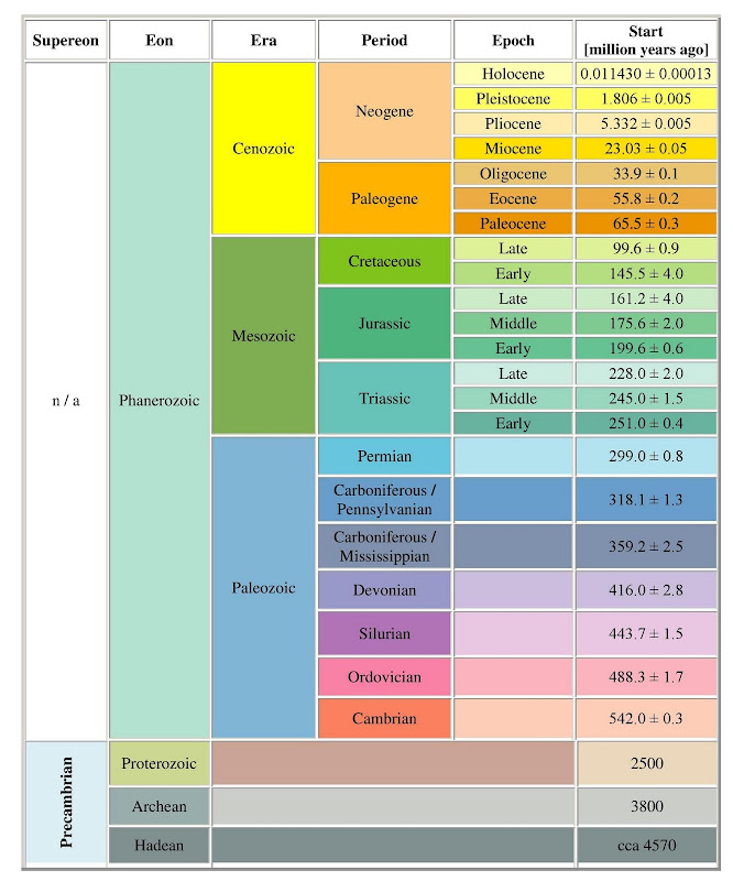
Geologic time scale
Tectonic characteristics of the Pivka basin
The important regional thrust called Snežnik thrust, that divides the Snežnik thrust sheet from the Komen thrust sheet, runs through the Pivka basin. A tectonic window near Knežak is proof of older thrusting deformations. The landscape is cut by numerous younger faults among which the most important are Raša, Predjama and Selce faults. The area of Upper Pivka is tectonically quite active, which is shown by earthquakes in recent years. It looks as if the most active is the Raša fault or one of its northern parallel faults, for example Šembije fault or maybe Selce fault. Karst intermittent lakes of Upper Pivka are developed in Upper Cretaceous limestones. The lakes are situated 0.5-4.0 km NE from the Snežnik thrust. Most of the lakes are situated along the Selce fault.
Geological map of Pivka basin with intermittent lakes (compiled by S. Šebela)
Legend: 1-railroad, 2-river with flow direction, 3-occasional stream, 4-hill with above sea altitude, 5-town, 6-smaller town, 7-karst cave, 8- intermittent lake, 9-alluvium (Quaternary), 10-flysch (Eocene), 11-limestone (Paleogene), 12- mostly limestone (Cretaceous), 13- thrust fault: stronger and weaker, 14-dextral movement along horizontal fault, 15-fault: established and covered, 16-anticline, 17-syncline
The Pivka basin is a very interesting region, not only because of the intermittent karst lakes and karst hydrology but also due to its interesting geological structure. In this area runs an important regional fault that divides two tectonic units and is called Snežnik thrust. The northern Snežnik thrust sheet is thrust over the Komen thrust sheet. The thrust can be tracked south from Gemona in Italy, through the Vipava valley, as the Snežnik thrust and NE from Rijeka in Croatia, which represents a total length of 160 km. For Pivka basin and for Snežnik region the moderate tectonic activity is characteristic of what can be seen in historical and recent earthquakes. There are plenty of geological and karstological characteristics in Pivka basin.
The biggest part of Slovenia belongs to the Adriatic (Adria) microplate. The Alpine belt is a result of convergence between African and Eurasian plates. The Adria microplate is mostly submerged beneath the Adriatic Sea and is covered by thick layers of young unconsolidated sediments in the river Po basin (Italy). Geologic and seismic research shows the probability that the E, W and N edges of the Adria microplate are underthrusting and forming the foreland to these surrounding deforming zones. The Adria microplate is probably moving slowly regarding the neighboring Eurasian plate. Adria’s major outcrop is the Istria peninsula of Slovenia and Croatia. On the bases of GPS measurements in western Slovenia we observe a significant and sharp (few mm/year) dextral shift along the Sava fault, Periadriatic zone, suggesting that lateral extrusion in the NE Alps is still active and being driven by ccw rotation of Adria.
Besides older thrusting deformations from the Miocene we can detect also younger neotectonic movements. The most important are the Predjama and Raša faults, which both show characteristics of dextral movement. For the Pivka basin the Selce fault is also very important. The fault runs from Prestranški ravnik towards SE to Koritnice and supposedly further on towards SE into the Snežnik Mountain. Most of the Pivka intermittent lakes are situated within the wider (1.5 km) area of Selce fault.
In the studied area the oldest rocks are well-stratified limestones and dolomite and limestone breccias (Lower to Upper Cretaceous), which can be found around Bač, Koritnice and E from Ilirska Bistrica. Following these are Upper Cretaceous limestones that form the Javorniki Mountains. Between Snežnik fault and Ilirska Bistrica there are the Vreme beds that belong to the period between Cretaceous and Paleogen. From the Eocene period we find flysch marls, sandstones and nummulitic breccias. The bottom of the Pivka basin is partly covered with river sediments. Sediments cover also the bottoms of bigger karst depressions-intermittent lakes. The intermittent lakes of Pivka basin are developed in Upper Cretaceous limestone.
Tectonic window at Knežak
Geology of the area around Knežak became subject of scientific research in the 19th century when geologist Guido Stache has written about the flysch basin of Reka as part of his research of the Eocene areas in the regions of Notranjska and Istria. He argued that the east (northeast) edge of the Reka flysch basin is overturned and bent towards southwest. In one part of this edge Eocene limestones can be found between the Cretaceous layers and Eocene flysch layers, whereas in the other part Cretaceous and flysch layers are joined with no Eocene limestones in-between. This also shows that the Cretaceous layers are partially thrust on flysch. Some geologists, however, have expressed their doubts that in the area around Ilirska Bistrica the Cretaceous limestones are really thrust on the Eocene flysch. Steep limestone step that is thought to represent the thrust terminus around Ilirska Bistrica extends to the southeast past Rijeka and Bakar. There it's been found that the steep step is just a vertical movement at the fault. In the northeast direction, between Pivka and Postojna, the limestone step slowly disappears and the layers return to the normal position. Cretaceous layers dip below the Eocene limestones and they underneath the flysch.
Southwest of Knežak, which lies on the limestone step, Stache noticed a larger patch of flysch, separated by a strip of Eocene limestone from flysch basin of Reka. He believed this flysch patch is connected to the flysch basin under the stratigraphically older limestone. Therefore, he was indirectly advocating the opinion that it is a tectonic window. In 1958, Slovenian geologist Mario Pleničar was mapping around Knežak and after a detailed examination of the terrain he confirmed Stache’s claims.
To better understand the tectonic situation, we need to know the normal transition of the Cretaceous limestones to Eocene limestones and them further into flysch on the outskirts of Reka basin. We can witness such a normal position of layers almost in the entire south-western outskirts of the Reka basin. Below there are dark bituminous Cretaceous dolomite and dolomitic breccias, then gray and white radiolitic limestones, after that Paleocene miliolidic and Kozina limestones and on top alveolinic and nummulitic limestones. The latter are becoming increasingly marly and change continuously and without clear boundaries to Eocene flysch marl, in which patches of lime and quartz sandstone begin to appear. Layers, in which we observe a continuous transition of nummulitic limestone to flysch marl, are 5 - 10 meters thick.
At Knežak, we also can see all of the above layers, only in the opposite sequence. This shows that the earth layers in this area once in the past have indeed overturned.
Geological Map and sections of the Knežak vicinity
Geological cross-sections C - D and E - F show us this situation and at the same time explain them with the folded edge of the Eocene basin, which was caused by thrusting Cretaceous layers of Snežnik towards southwest. The turned up border of the basin forms the recumbent fold. In the extreme northwestern part of the map at Velika Pristava this fold doesn't include flysch layers (see section A - B). From Šilen Tabor to Podtabor the flysch already is part of the fold. It is indented to the depth of about 2000 m and in two places it shows itself through the torn wing of the recumbent fold from beneath the numulitic limestone in the form of tectonic windows. At Podtabor the pressure of Cretaceous layers ruptured the fold and Cretaceous massif has penetrated to the flysch basin. The edge with the Eocene and Paleocene limestones remained under the overthrust Cretaceous layers (see section G - H).
At villages Knežak and Zagorje there are two patches of fertile flysch in the middle of karstic limestone. Geological conditions can be studied especially nice in the patch at Knežak. There the flysch falls under the limestone layers all around the edges of the patch and at the same time limestone layers are forming a steep step. Tectonic window was therefore formed by anticlinal bending of the flysch when the edge of the flysch basin was bent back to the southwest. Flysch layers that can be observed in the tectonic window are thus overturned, as well as all limestone layers from Cretaceous to Eocene. Very similar is situation at Zagorje, only there the flysch edge is covered with weathered debris and geological conditions are not as obvious as at Knežak.
Evidence of an overhrust can be found in the torrent clefts that are cutting the edge of the overthrust perpendicularly. In these clefts the flysch is extending way up to the north-east, proving that the flysch is under the limestone. The front of the overthrust as well as the recumbent fold is geomorphologically expressed in the form of the steep limestone wall above the flysch basin.
The recumbent fold and limestone thrust onto flysch also have some interesting hydrological consequences. They are probably the reason why River Pivka is originating in the high Karst plateau at Zagorje and Parje and runs north, not south. Until they were used for water supply and for other purposes, some water flowed to Pivka from numerous springs, which originate in the flysch of the two tectonic windows. However, the main water supply to the River Pivka, which has the first spring in Zagorje and the other in Parje, comes from the north-east, from the area of Snežnik. If it were not for the flysch barrier formed by folding and thrusting, water would flow out in full to the flysch basin of Reka, like it partially does from the source of Bistrica in Ilirska Bistrica and perhaps from the spring in Podstenjšek. Thus, the bulk of the incoming water from Snežnik rebounds from the flysch barrier and runs from Zagorje and Parje past Radohova vas and Petelinje to Postojna, through the cave of Postojna, the Karst-fields of Planina and Logatec, and reappears near Vrhnika as River Ljubljanica. This part of the water is therefore redirected relatively close to the Rijeka bay out of the Adriatic basin and towards the Black Sea basin. If we consider that this water horizon reaches almost to the very edge of 50-70 m high limestone step and 130 - 150 m above the valley of the River Reka, the importance of the flysch barrier, caused by tectonics, is even more evident.
On the flysch in the tectonic window a dark brown soil formed. Layer of this soil is about 25 cm thick, the soil is medium fertile and medium grainy. In the past, there were as many as 48 springs in Selo, as locals call the area of tectonic window, and the whole area was quite wet. This was because the flysch is impermeable to water, so water cannot sink there, but rather remains on the surface. There were a lot of fields, meadows and water holes for watering cattle. Today there is less wetlands and the surface is much drier, partly because many of the springs were captured for drinking water. Due to other causes, however, there is also less meadows, whereas fields are completely gone. A lot of land is overgrown and water holes have fallen into decay. A few years ago one of them was restored for recreational purposes.
Access
To get to this EarthCache, one should go from Postojna in the direction of Ilirska Bistrica and Rijeka in Croatia. After a few kilometers the road will bring you to Pivka, where in the center do not turn right on the priority road, but go straight in the direction of Knežak. Another option is to go from Ilirska Bistrica towards Šembije and Knežak.
Tectonic window is close to the main road from which a cart track leads to it. We recommend that you leave the car in the parking lot at the petrol station in the village (waypoint PARK1) and then walk a few hundred meters to the EarthCache. Leave the main road at waypoint TURN, where you turn west on the cart track. If you would like to avoid some walking, drive your car off the main road at waypoint TURN and along the cart track to waypoint PARK2. From there, you will explore the terrain on foot.
Access to this EarthCache is possible throughout the year, as the main road through Knežak is plowed, but a visit at a time when there’s snow is not reasonable, as it would be difficult to answer the questions below. We therefore recommend that you check this EarthCache at a time when there is no snow.
EarthCache
To register this EarthCache you must answer the following questions:
1. Waypoint KNE1 is at a water hole which was in the old days used to water livestock. Assess its dimensions along the longer and shorter axis.
2. Describe what the slope at waypoint KNE2 looks like and what can you see there.
3. In your opinion, is there more or less water in the tectonic window than its surrounding area? Why do you think it is so?
4. Optionally, take a photo of yourself or your GPS at the restored water hole and attach it to your log.
Send your answers in Slovene or English through my GC profile. After that you can log your visit, don't wait for permission from me. If there’s something wrong with your answers I will contact you.
If you took photos, attach them to your log.
Logs without the answers sent to me or logs containing the answers will be deleted!
(English)
Viri / Sources:
- Wikipedija / Wikipedia
- Pleničar M., 1959: Tektonski okni pri Knežaku / Two tectonic windows at Knežak. – Geologija, 5. knjiga, 5-10, Ljubljana
- Šebela S., 2005: Tektonske zanimivosti Pivške kotline / Tectonic sights of the Pivka basin. – Acta carsologica, 34/3, 566-581, Ljubljana
Slike / Photos (Preskoči / Skip)
(Vrh / Top)