PROSÍME POZOR !!
Vypadá to, že se lesní cesta od parkoviště zalíbila včelařům a pojali ji jako sezonní bydlení pro včely.
Pokud si zrovna s tímto druhem létajícího hmyzu netykáte zvažte sice delší, ale bezpečnější cestu od Silůvek.
Tato tradicni kes Vas privede na misto udalosti, ktera se zde stala pred padesati lety.
Patnacteho brezna 1965 ve 14.35 vzletla z vojenskeho letiste Namest nad Oslavou dvojice letounu MiG-15. V kokpitech sedeli kapitan Bäumelt (velitel skupiny) a nadporucik Rostislav Minks.
Dvojice mela plnit zadany cvicny bojovy ukol: po prekonani useku Nedvedice – Vyskov – Napajedla – Bzenec – Pohorelice– Ivancice provest pruzkum pohybu vojsk po silnici Orechov – Ivancice ve vysce 200 metru.
Po zjistení cile provedl velitel dvojice nalet, pricemz nedodrzel predepsanou vysku vybrani 200 metru nad terenem a snizoval ji na 100 až 150 metru.
Vzhledem k tomu, ze objekt pruzkumu byl v uzkem udoli, vybirali piloti zatacku pod urovni obou hrbetu tohoto udoli. Vedoucimu dvojice se podarilo v male vysce prulet dokoncit.
Nadporucik Minks v leve zatacce pred timto pruletem provadel pomaly vykrut. Nespravnou pilotazi presel do sudoviteho vykrutu, sklouzl po kridle a pro nedostatek vysky narazil do protisvahu asi padesat metru pod vrcholem kopce s kotou 386,6.
Naraz v rychlosti 500–550 km/hod pod uhlem 10° letoun zcela znicil. Pilot v male vysce pri maximálním naklonu nemel moznost pouzit záchranny padak, ani nestihl provest pokus o katapultaz.
Rostislav Minks se narodil 25.9 1939. Po absolvovani stredni skoly v Bucovicich zakoncil vzdelani ve Vojenskem leteckem ucilisti roku 1959 jako pilot. K 20. stihacimu bombardovacimu leteckemu pluku v Namesti nad Oslavou nastoupil 3.7 1964. Byl zenaty a mel jedno dite.
Komise pro mimoradne udalosti konstatovala, ze nestesti nemelo zadnou spojitost se zdravotnim stavem pilota a technickym stavem letounu. Hlavni pricinou byla nekazen pri nedodrzeni stanovene bezpecnostni vysky letu.
V miste nestesti je dnes maly pomnicek se zbytky drobnych casti letounu nalezenych houbari.
Místo dopadu letounu je asi 25m od pomnicku
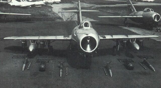
Technicke parametry letounu MiG-15 SB:
Motor: VK-1
Tah motoru: 26,5 kN
Rozpeti kridel: 10,08 m
Delka: 10,86 m
Vyska: 3,70 m
Max. rychlost: 1 076 km/h
Max. stoupavost: 46 m/s
Hmotnost prazdného letounu: 3 740 kg
Max. vzletova hmotnost: 5 641 kg
Dostup: 15 500 m
Dolet: 1 750 km
Cas vystupu do vysky 5 km: 1,95–2,10 min
Cas vystupu do vysky 10 km: 5,5 min
Jak na kes:
Z nádrazi Siluvky (at uz pesky nebo na kole) se vydejte po modre turisticke znacce smer Hlina.
Na waypointu odbocte vlevo na lesni cestu, po ktere dojdete temer ke kesi.
Trasa je dlouha priblizne 2.5km.
Pokud prijedete autem .... viz doporucene parkovani.
Odtud je to po ceste ke kesi necely kilometr.
Teren 2.5 plati pro zaverecnych 100m. Jinak je to pekna lesni cesta.
DULEZITE:
1. Auto parkujte na doporucenem miste.
2. Pres cestu je zavora, ktera je vetsinou zavrena.
I kdyby nahodou nebyla - NEJEZDETE ZA NI ! Jsou tam lesaci a mate problem!
3. Na krabku opatrne a vracejte ji tak aby po Vas delala radost i ostatnim.
4. Dodrzujte pravidlo poctive vymeny.
5. A hlavne! Nezapomente, ze jste v lese. Takze se chovejte jako zvirata – tise a nenapadne.
PREJEME PRIJEMNOU PROCHAZKU....
Hobakovi za provedeny Betatest a pomoc se zamerenim ****
****** ENGLISH ******
This traditional cache will guide you to a place of an event, that happened fifty years ago.
On the 15th of March 1965 at 14.35 sharp, two MiGs - 15 took off from the Namest nad Oslavou military airfield. Capt. Bäumelt (group leader) and first lieutenant Rostislav Minks sat in their cockpits.
The couple was supposed to fly on a training recon mission: after flying over Nedvedice – Vyskov – Napajedla – Bzenec – Pohorelice– Ivancice, they were supposed to perform a reconnaissance of military troops on the Orechov – Ivancice road at the altitude of 200 meters.
After the target had been confirmed, the leader attacked not keeping the pre-set lowest safe altitude of 200 meters. Instead, he flew below this level at the altitude of 100 to 150 meters.
Since the target was located in a narrow valley both pilots performed a turn below the ridge of the two hills. The leader was able to finish the turn at this low altitude.
The First lieutenant Minks crashed the plane into the hill side (386,6m high hill) about 50m below the summit at the speed of about 500-550km/h. At this speed the plane was totally destroyed on the impact.
The pilot had no chance whatsoever to eject at such a low altitude.
Rostislav Minks was born on 25th September 1939. After graduating from the Bucovice high school he attended and graduated from the pilot military academy in 1959. He joined the 20th Fighter Bomber Air Regiment in Namest nad Oslavou on the 3rd July 1964. He was married and had one child.
Civil aviation safety board stated that the pilot’s health and technical status of the aircraft had no connection with the crash. The main cause was the disobedience of the pre-set lowest safe altitude.
There is a small headstone at the crash site surrounded by small pieces of the plane found by mushroom pickers.
The crash site is approx. 25m (82ft) far from the headstone
MiG-15 SB technical specifications :
Motor: VK-1
Thrust: 26,5 kN
Wing span: 10,08 m
Length: 10,86 m
Height: 3,70 m
Max. speed: 1 076 km/h
Max. rate of climb: 46 m/s
Empty weight: 3 740 kg
Max. takeoff weight: 5 641 kg
Ceiling: 15 500 m
Ferry range: 1 750 km
Time to climb to 5km: 1,95–2,10 min
Time to climb to 10 km: 5,5 min
How to find the cache:
From the Siluvky railroad station (either on foot or by bike), follow the blue hiking trail towards Hlina.
At the waypoint, turn left on the woods path along which you can get almost to the cache.
The route is approximately 2.5km long.
If you get there by car .... follow the instructions on recommended parking.
It’s less than a kilometer to the cache from here.
Terrain 2.5 is just the last 100m. Otherwise it’s a nice woods path.
IMPORTANT:
1. Park your car at the recommended place.
2. There’s a boom gate across the road so I hope nobody tries to drive through.
3. Put the box back undamaged so that others can have fun as well.
4. Make sure you follow the trading etiquette.
5. And most importantly! Remember that you’re in a forest so behave like animals – be quiet and inconspicuous.
ENJOY THE WALK....
**** Thanks to the reviewer for the cooperation, my brother for the translation and