Please follow the:

This is a great bicycling cache or if you like longer walks.
This cache can be solved with just these instructions and your GPSr. You are not required to rank yourself as a Navigator but we would like for you to do so in your online log, you may choose to post your rank as navigator, using the following criteria:
1) Master Navigator - You solved this multi with only these instructions and your GPS.
2) Journeyman Navigator – You used a handheld compass, these instructions and your GPS.
3) Apprentice Navigator – You called a friend for help, used these instructions and your GPS.
4) Navigator Applicant – You had to use an online tool or "An app for that" as part of solving this cache.
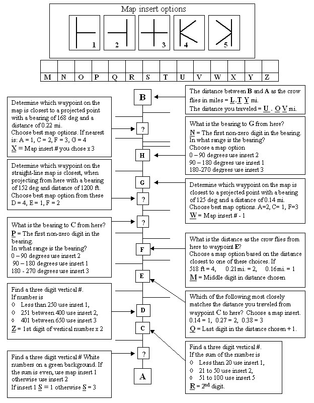
At the posted coords, you will get your instructions to find point "A". From point "A" you will travel to point "B" using the map and map instructions to guide you. At point "B", you will calculate the location of stage 3. At stage 3 you will calculate the location of the final, using the information you have gathered.
Map Travel Instructions:
The "Path" is defined as Blacktop path, concrete sidewalk, painted or unpainted crosswalk.
An "Intersection" for this cache is defined as where:
- Two or more paths meet
- Two or more crosswalks meet
- Access to the path from a playground, tennis court or other public use facility.
- The following are excluded: Roads, private walkways or driveways. At no time except for crossing roads does the route go on a road for motorized vehicles.
At each intersection, you must decide to turn left, right or go straight.
"Puzzle intersections" are marked with either a capital letter or a question mark.
Answer the puzzle question and choose the appropriate map insert from the list of choices given. Then continue your journey.
Point "B" on the map is the nearest lamppost after your have traveled W.MN miles from the last intersection.
- To reach stage 3, project a waypoint from point B with a bearing of WPQ degrees and a distance of QPT feet.
- At the coordinates go to the nearest lamppost make your heading WWM, then proceed 7 paces to find this stage.