Il-Maqluba Sinkhole EarthCache
-
Difficulty:
-

-
Terrain:
-

Size:  (other)
Please note Use of geocaching.com services is subject to the terms and conditions
in our disclaimer.
Il-Maqluba
"Il-Maqluba" located at Qrendi in Malta means "the upside down" or "upturned". It is a doline or sinkhole which have formed after a natural cave have collapsed. It have formed a hole with a depth of 15m and a perimeter of 300m.
Sinkholes may capture surface drainage from running or standing water, but may also form in high and dry places in a certain location. The mechanisms of formation involve natural processes of erosion or gradual removal of slightly soluble bedrock (such as limestone) by percolating water, the collapse of a cave roof, or a lowering of the water table. Sinkholes often form through the process of suffosion. Thus, for example, groundwater may dissolve the carbonate cement holding the sandstone particles together and then carry away the lax particles, gradually forming a void.

Sinkholes are common where the rock below the land surface is limestone or other carbonate rock, salt beds, or rocks that can naturally be dissolved by circulating ground water. As the rock dissolves, spaces and caverns develop underground. These sinkholes can be dramatic because the surface land usually stays intact until there is not enough support. Then, a sudden collapse of the land surface can occur.
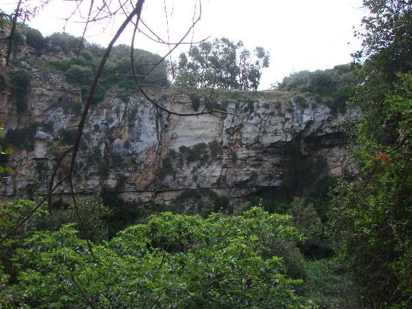
The cave at "Il-Maqluba" is beleived to have collapsed in 1343 after Malta have experienced one of its most severe winter storms ever, possibly accompanied by an earthquake. This is a natural depression formed by the collapse of the underlying limestone strata, known as a doline in geological language. It is now a sinkhole, collecting rainwater from a three mile radius. This water is much needed to cater the needs of its thick vegetation whilst allowing its access supply to penetrate the rock formation helping to maintain underground water supplies.

The doline is superimposed onto the main tributary of "Wied Babu", which it divides into two ("Wied San Mattew" and "Wied Ħal-Lew", "wied" meaning "valley"), thus adding to its uniqueness.
To complete this Earthcache all is needed is to answer the following,
- What kind of doline do you think "Il-Maqluba" is from the six types in the above figure? Describe briefly your choice.
- How many stairs are there from the waypoint listed below to the final coordinates?
- Walking your way to the GZ and on the right one can meet a sort of way to get down to the bottom of the sinkhole. Can you explain what is this way?
...
Take a photo with your GPS and upload it once you have been granted permission to log this Earthcache.

|
| I am a proud |
 |
Additional Hints
(No hints available.)