Rock Tales Earth Cache EarthCache
-
Difficulty:
-

-
Terrain:
-
Size:  (other)
Please note Use of geocaching.com services is subject to the terms and conditions
in our disclaimer.
This is an earth cache. There is no container to find. You must visit the coordinates listed to answer the questions list below to the best of your ability. This earth cache is located on a rock cut off west bound Highway 1. There is ample parking on the very wide gravelled area off the paved shoulder of the highway. None the less, children and pets must be closely supervised while at the cache site. BE AWARE..... There is potential for falling rock.
I am not a geologist, just an interested layman. I used Wikipedia as a reference when preparing this earth cache. After I studied the tale the rocks were telling, I confirmed my theory with a Post Graduate Geology student at the University of New Brunswick.
There are three Rock types; Igneous, Metamorphic and Sedimentary.
Igneous rock is formed through the cooling and solidification of magma or lava. Igneous rock may form with or without crystallization, either below the surface as intrusive (plutonic) rocks or on the surface as extrusive (volcanic) rocks. Some Igneous rocks you may know from everyday use are Granite, Scoria and Pumice. Granite is used in monuments and countertops. Scoria rocks are the rocks you find in your Gas BBQ. Pumice is used to exfoliate.
Metamorphic rocks may be formed deep beneath the Earth's surface where they are subjected to high temperatures and the great pressure from the rock layers above them. They are also formed when rock is heated up by the intrusion of hot molten rock called magma from the Earth's interior. Some examples of metamorphic rocks are slate and marble.
Sedimentary rocks are formed by the deposition of material at the Earth's surface and within bodies of water. Sedimentation is the collective name for processes that cause mineral and/or organic particles to settle and accumulate. Before being deposited, sediment was formed by weathering and erosion in a source area, and then transported to the place of deposition by water, wind, ice or glaciers. Commonly known sedimentary rocks are Shale, Limestone, Coal, Sandstone, Claystone and Siltstone.
A fault is a fracture in a volume of rock as a result of earth movement. The two sides of a non-vertical fault are known as the hanging wall and footwall. By definition, the hanging wall occurs above the fault and the footwall occurs below the fault..
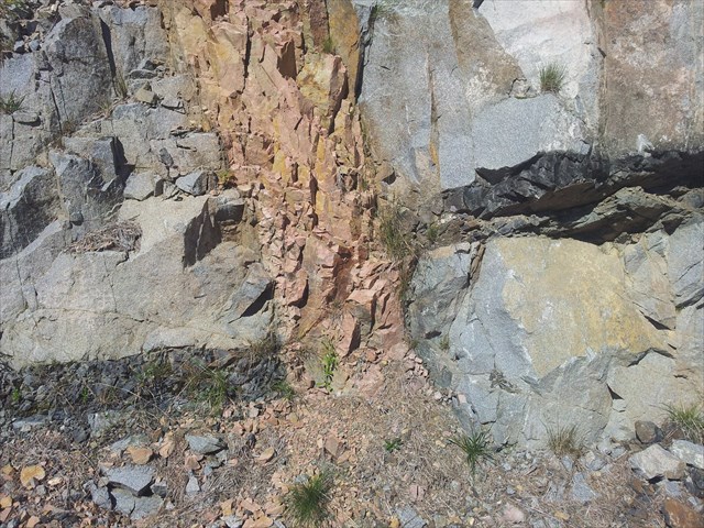
At the site of the Earth Cache you will find the fault pictured below. There is also a sill running horizontally at this site which is the subject of another earth cache "Volcanic Intrusion GC3BW96". This sill consists of basalt an Igneous rock.
As you can see in the photo and at the site, the country rock (Granite) formed first. It is an Igneous rock that cooled slowly allowing the minerals to crystalize and separated into grains that are visible in the rock.
Sometime later, a gap formed in the country rock. Magma found its way into this gap and cooled quickly in contact with the granite heat sink surrounding it. This prevented the formation of crystals; therefore, the basalt in the sill is very fine grained.
Later, the fault may have been filled with silt which over time solidified to form Siltstone. This is distinguished from Sandstone or Claystone by the size of the grains that formed the rock. Siltstone consists of grains that are smaller than Sandstone and larger than Claystone. Or, it may be that a Dyke of Laval flowed up this fault and cooled quickly to form very fine grains within the rock. Without lab testing it is not possible to say forsure.
TO LOG THIS CACHE: Send an email stating the cache name, the number of people in your party and answer the following questions:
At the fault line (pictured above), what is the distance the sill dropped? (measure from bottom to bottom or top to top of the sill)
What is the width of the Fault near the sill.
In your own words, explain how you believe the rock came to form within the fault.
Feel free to memorialize your visit with a photo along with your found log.
Log your find anytime but I must receive your email answers within a day or two to prevent the deletion of your log.
FTF goes to Ranger170, Congratulations Ranger.....
| I have earned GSA's highest level: |
 |
Additional Hints
(Decrypt)
GB YBT GUVF PNPUR: Fraq na rznvy fgngvat gur pnpur anzr, gur ahzore bs crbcyr va lbhe cnegl naq nafjre gur sbyybjvat dhrfgvbaf:
Ng gur snhyg yvar (cvpgherq nobir), jung vf gur qvfgnapr gur fvyy qebccrq? (zrnfher sebz obggbz gb obggbz be gbc gb gbc)
Jung vf gur jvqgu bs gur Snhyg arne gur fvyy.
Va lbhe bja jbeqf, rkcynva ubj gur fvyg pnzr gb frggyr va gur snhyg.
Srry serr gb zrzbevnyvmr lbhe ivfvg jvgu n cubgb nybat jvgu lbhe sbhaq ybt.
Ybt lbhe svaq nalgvzr ohg V zhfg erprvir lbhe rznvy nafjref jvguva n qnl be gjb gb cerirag gur qryrgvba bs lbhe ybt.