The park at the GZ is a remnant of rock quarry left in Hillside Park. The north facing side of the hill is a great exposure of the bedrock underlying the Cincinnati area.
Per Doug Aden, a Ohio Department of Natural Resources geologist, this rock exposure is part of the “FAIRVIEW” formation of the Cincinnati series. This series of geologic formations is so named because much of the early studies in western Ohio were done near Cincinnati as it emerged as an important river port in the early 1800’s. Many of the formations (layers) are named for other regions nearby where they were first identified: Fairview, Point Pleasant, and Miamitown.
The Ordovician bedrock system here is southwest Ohio is the oldest rock exposures in Ohio. It is due to the “Cincinnati Arch”. The arch was formed as regions to the northwest and southeast the earth’s crust subsided. Later erosion would expose the bedrock that lies under southwest Ohio. The underlying bedrocks layers are shown below.

These bedrock layers are shown in the graphic below.

The chart above shows the latest naming conventions, but often as I was researching this you come across the older naming convention shown below.

(Note how many of the strata are named for Ohio locations: McMicken, Southgate Bellevue, Corryville, etc.) The chart above not only functions as a cross reference for formation names, but highlights that at different time periods different amounts of shale and limestone were deposited. Now we’ll discuss how these different layers of bedrock came to be here.
The layers are evidence of the sedimentation that occurred while our region of Ohio existed below a warm shallow sea. Ohio was in southern tropical latitudes and dominated by warm, shallow seas.
So how did Ohio move from the tropics 450 million years ago to our current location? And how did it come to be dry land? It is because the crust of the earth rides on a sea of molten rock. The currents and flows of this molten rock cause whole continents to rise, fall, and be transported about the globe.

On the map below the outline of the todays North America is shown where is lay beneath the sea.

The map below shows a close up on what southern Ohio looked like 450 million years ago.
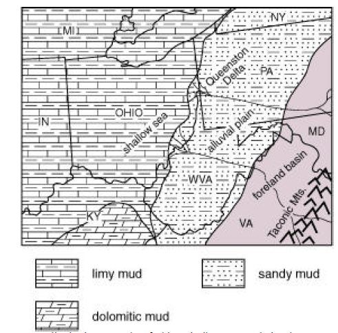
To the east of Ohio was an alluvial plain and further east was a mountain range. This ancient mountain range and plain were southeast were the source of
mud carried far out into the shallow sea that covered Ohio. The layers limestone (the thicker, sturdy, lighter color) and shale in between you see on the hillside were deposited by a number of different processes. For example the finer grained layers are probably deposited slower as fine grain sediments settle out of water. The layers with large fossils may have formed more quickly as many organisms were swept up in a storm (for example) and then rapidly buried and lithified (turned to rock). There can also be periods of mud being deposited from the land to the east.
Overall, the Cincinnatian rocks represent a progressive sequence in which most shale-dominated units reflect deposition in deeper, quieter waters and the limestone-dominated units represent deposition in
clearer, shallower waters. Many of the thin beds of limestone show evidence, such as graded bedding,
of having been deposited during storm events and are called "tempestites." The percentages of limestone and shale due to this process are shown in the chart above.
The layers represented by units that have nearly equal percentages of limestone and shale.
These rocks were deposited in shallower (less than 50 feet) waters, but the sea bottom was still below
the fair-weather wave base. The Fairview Formation; portions of the Grant Lake Formation, the Grant
Lake Limestone, and the Arnheim Formation; and the Liberty Formation were deposited in this environment.
Another way geologists understand how the bedrock was deposited and the environment of that age is by the fossil record contained in the stone.
Fossils, in combination with the rocks in which they are found , can be used to understand the environment of the usersea Ohio. Most animals line in a specific environment. While some kinds of sediment can be deposited in more than one environment (for example, mud could indicate either a lake or deep marine habitat), fossils that are present can tell us which (if you find shark fossils in mud, then it was a deep marine environment).
The shape of an animal provide information on its lifestyle. When combined with the rock details we can better understand the live conditions of the past. Although all of the fossils in the Cincinnatian were deposited in a climate similar to the seas around the Bahamas, during different times, sea level was low or high.
Wave energy in shallow, nearshore setting is high compared to deeper water. In the shallow seas, wave turbulence dominate the environment. Only the more robust organisms that can attach to otherwise be protected from the high energy can survive, such as huge, encrusting (clinging to rocks) bryozoans and thick-ridged brachiopods. The Fariview Formation you are visiting is a deep subtidal layer where the creatures were subject to storms, but were submerged deeper than a fair weather wave action.
When the water is deeper and there is less wave action – more delicate and smaller creatures can live – such as lacy bryozoans and thin shelled, tiny brachiopods. The Kope layer that lies under the Fairview layer contains many of the fossils. Below is a graphic of Kope and Fairview fossil types.


This brings us back to why there’s a quarry here and why they stopped excavating where they did. The Fairview layer has a much higher content of limestone, which is the mineral that was sought after for construction purposes. The Kope layer lies near the bottom of the rock face and is under the current baseball fields. The Kope layer per the charts above has much less limestone.
Email the answers to these questions BEFORE logging a find on this earthcache:
1) Use your GPS to determine the height of the exposed rock layer. Per the State of Ohio Geology Department the bulk average rate of deposition of these exposed layers is 0.552 inches per 1,000 years, Estimate how many years it took to formed this bedrock.
2) Look at a sample of fossils from near the top of the hill face and the bottom. Are they consistent with the typical fossils in the Fairview and Kope Layers? Which fossils did you see the most?
3) OPTIONAL: A picture of yourself at the site.