Please follow the:
If you liked this one, you may want to try one or more of these caches.
Map Travel Instructions:
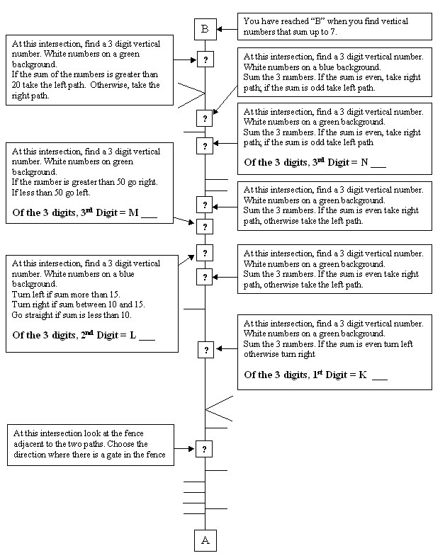
You will travel from point "A" to point "B", following the modified straight-line map below. The map also has undefined intersections. You will have to determine the direction of the route by answering a question when you reach the intersections marked with a "?".
A straight-line map is a simplified drawing of how a mapped route would look if it was a piece of string that was then pulled straight, with all of the connecting paths still attached. The straight line represents the path(s) being traveled at all times (although the actual route will not look anything like the diagram). To the left or right of the central line are "branches" which are instructions for what to do at each intersection.
The "Path" is defined as Blacktop path, concrete sidewalk, painted or unpainted crosswalk.
An intersection for this cache is defined as where:
- Two or more paths meet
- Two or more crosswalks meet
- Access to the path via:
- Public access point
- Play ground access
- Other public use facility with access
The following are excluded: Roads, private walkways or driveways. At no time except for crossing roads does the route go on a road for motorized vehicles.
At each intersection, you must decide to turn left, right or go straight. For example if the branch attached to the center line on the map points left, you must either go straight or turn right . Or if there is a branch on each side, then it is an 4 way intersection and you must go straight through. Two branches on one side also means a 4 way intersection where you must turn.
When you come to a puzzle intersection and for example the answer to the puzzle is "left" that would mean the dead end branch would be on the right side of the straight line.
To find your start location (point "A") go to the posted coordinates. There you will find a sequence of 7 digits ending with the letter "S". Black numbers on a white background.
| ___ |
___ |
___ |
___ |
___ |
___ |
___ |
S |
| A |
B |
C |
D |
E |
F |
G |
|
| U = |
B+D+E |
___ |
|
|
X = |
B-E |
___ |
| V = |
B+F |
___ |
|
|
Y = |
D-G |
___ |
| W = |
C+D |
___ |
|
|
Z = |
A+D+F |
___ |
| point "A" = |
N41 45. |
___ |
___ |
___ |
W88 06. |
___ |
___ |
___ |
| |
|
U |
V |
W
|
|
X |
Y |
Z
|
To find the cache, go to point "A" make your heading 250 and ride your bike or walk to point "B" following the map. Record your distance traveled from point "A" to "B" via the route you traveled. At puzzle intersections record the numbers you need to solve the final projection.
You will know that you have reached point "B" when you find a vertical number that sums to 7.
From this spot (point "B"), you will project the location of the cache.
Distance traveled via route in miles (to the nearest 1/10th mile).
A straight line (as the crow flies) from point A to B (to the nearest 1/10th mile).
Clues obtained from the intersections on the path.
Bearing = (N - L)___, (M - B)___, (K + 6)___ deg.
Distance = (A)___, (N - 3)___, (B+B)___, (F)___ feet