For more information on floating the river and the first EarthCache in this series, please see this link.
-------------------------------
Up From Below – Reverse Faults
The vast majority of strata (layers of rock) in the Missouri Breaks are horizontal, reflecting the lack of tectonic activity in the region since the rocks were laid down 90-70 million years ago. However, while floating downstream, you may have noticed that there are more angled beds along this part of the river. These tilted beds demonstrate that the rocks here have experienced deformation due to the influence of imposed stresses (a force over an area).
The prominent knife-edge ridge before you (on river left, straight ahead of you from this perspective) is a structure created by a fault. A fault is a surface along which rocks have moved relative to one another. Most of the time faults are inactive. But when faults suddenly activate and rupture, they can release massive amounts of energy, which move through the Earth in the form of seismic waves. We feel these seismic waves on the surface as earthquakes.
Geologists have classified two main groups of faults: dip-slip faults and strike-slip faults. To understand them, we must first review some basic fault geometry:
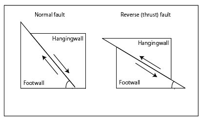 A 2-D block model of two common fault types (see below) illustrating the motion of the hanging wall relative to the footwall (Wikipedia Commons)
1) The fault plane is the surface formed by the boundary between the two fault blocks
2) The hanging wall is the fault block above the fault plane, and moves up or down relative to the footwall
3) The footwall is the fault block underneath the fault plane, which typically does not have much noticeable movement
Dip-slip faults are those in which the fault blocks have shifted vertically, and the fault plane is on a diagonal. There are two classes of dip-slip faults: normal faults and reverse faults.
Normal faults are caused by extensional forces in regions where the Earth’s crust is being pulled apart, such as the East African Rift. In normal faults, the hanging wall drops down relative to the footwall.
 A 3-D block model of a normal fault; the hanging wall (right) drops relative to the footwall
Source: Nathan Toké, Sun Valley Elementary, http://www.public.asu.edu/~ntoke/Gk-12.html
A 3-D block model of a normal fault; the hanging wall (right) drops relative to the footwall
Source: Nathan Toké, Sun Valley Elementary, http://www.public.asu.edu/~ntoke/Gk-12.html
Reverse faults, on the other hand, are formed due to compressive stresses, where the Earth’s crust is being pushed together in collisional environments, such as the Tibetan Plateau, home to the Himalayas. In a reverse fault, the hanging wall moves up relative to the footwall. Most reverse faults take the form of thrust faults, which have a fault plane angle of less than 30º. Thrust faults cause displacement that is more horizontal than vertical due to the low angle of the fault plane.
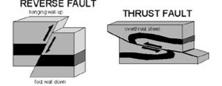 Block model of reverse faults
Source: US Geological Survey, Public Domain
Block model of reverse faults
Source: US Geological Survey, Public Domain
Strike-slip faults are those in which the fault plane is nearly vertical, and the fault blocks move laterally, or sideways against each other, with little to no up or down movement. Strike-slip faults are classified as right- or left-lateral, depending on the motion of the fault. The San Andreas Fault is a well-known strike-slip fault that has caused several devastating earthquakes in California.
 Diagram of a strike-slip fault, by Dale Glasgow
Now that you know about the different kinds of faults, we can talk more about faults the in the Missouri Breaks. Nearly all of the faults here are reverse faults. It’s unusual to find a concentration of faults far from any tectonic boundaries, but Frank Reeves, a geologist who studied the area in the 1940s, proposed a theory for their formation. Reeves argued that the faults in the Breaks are linked to the igneous activity that formed the Bear Paw Mountains 50 million years ago. According to Reeves, the large-scale intrusions that formed the Bear Paw Mountains uplifted the overlying sedimentary rocks to such an extent that they domed upwards, and eventually slid off. This process is called gravity sliding. Reeves believes that tremors caused by the injection of magma, possibly aided by a lubricating effect of weak clay beds (bentonites) in the shale formations below, facilitated the slip of these sedimentary layers. These shifting blocks generated compressive stresses on the surrounding rock, leading to deformation and reverse faulting around the Bears Paw Mountains. Reeves’ theory is still controversial and sometimes contested, but a map of the geologic structures in the region reveals a concentric ring of faults around the Bears Paw Mountains, making quite a compelling argument for his hypothesis.
The ridge before you is composed of the same white Eagle Formation sandstone that is responsible for the famous White Cliffs visible upriver. This hard sandstone is resistant to weathering; while the surrounding rock here has eroded away, the steeply pitched sandstone ridge remains as evidence that a fault is present. According to the Principle of Stratigraphic Superposition, younger sedimentary strata lie on top of older strata. Because the Eagle Formation lies below the Judith River Formation, we know the Eagle formation is older. Yet here we see the two formations beside each other—the faulted ridge of Eagle Formation sandstone is bound on either side by valley slopes of the Judith River Formation. This tells us that the fault here pushed the Eagle Formation up into the Judith, and so we know this must be a reverse fault. Thrust faults and reverse faults are often responsible for bringing up sections of older rocks into younger ones.
To claim this cache: Answer the following questions and send the answers using Geocache's messaging tool.
Q. You’ll notice that the ridge looks like a stegosaurus’ back. How do you think these “fins” formed?
Q. What is the evidence that this feature was formed by a reverse fault? (Hint: Consider the rock types involved. Look at the stratigraphic column from the previous EarthCache.)