For more information on floating the river and the first EarthCache in this series, please see this link.
For the next EarthCache in the trail, click here.
-------------------------------
Go with the Flow — Slides in the Breaks
This EarthCache is another floater-by. As you approach the given coordinates, look to river left and you should see a “fan” of dark sediment coming out of a coulee towards the river. Along the Upper Missouri, the sedimentary rocks that make up the Breaks have different properties. Sandstone, for example, is relatively strong and able to hold its shape at steep angles, as seen in the magnificent White Cliffs upriver. Mudstone, however, is less stable and often crumbles away, forming more gradual slopes. This results in the typical “staircase” topography of the Judith River Formation, which is made up of alternating sandstone and mudstone beds.
Located above the Judith River Formation is a thick layer of shale that is also susceptible to slope failure. The dark riverside deposit here is a result of the above shale layer collapsing onto the Judith River Formation below. It is an example of mass movement or mass wasting, the transport of material downslope under the influence of gravity.
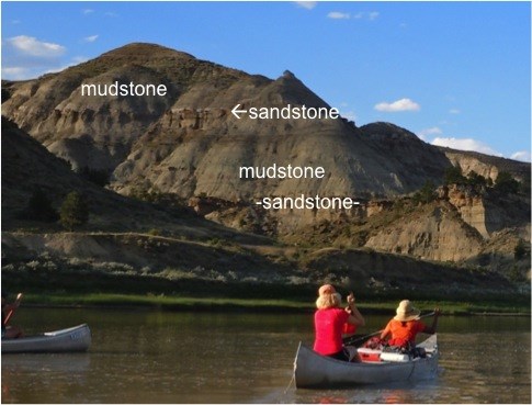 Cliff-forming sandstone and shallower mudstone slopes (Photo by Daniel Morel)
A mass movement event is classified based on the type of material moved (sediment, rock, or muddy water), the type of movement involved, and the speed of the event. A landslide is an umbrella term that refers to any failure in slope.
Getting more specific, a translational slide is a slope failure that occurs along a well-defined planar surface. The surface is usually a bedding plane between unconsolidated sedimentary layers, or a joint plane dividing solid rock. Before or after going out on the river, make sure to watch this video, a spectacular example of a translational rockslide captured by a road camera. Notice how the entire slide is along a single joint plane in the rock, visible after the slide occurs and at the end of the video.
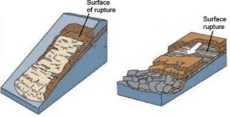 A translational landslide of sediment (left), and rockslide (right)
Source: Maine Landslide Inventory Questionnaire, http://www.maine.gov/doc/nrimc/mgs/slide-form.htm
A translational landslide of sediment (left), and rockslide (right)
Source: Maine Landslide Inventory Questionnaire, http://www.maine.gov/doc/nrimc/mgs/slide-form.htm
A slump is a non-planar landslide that has a rotational component to it. Slumps are also slower, and can form over a span of days. As a slump “collapses in” on itself, the sediment separates into separate slump blocks, which form visible scarps, scars left behind where the sediment slid downhill. Slumps also tend to splay out (expand in width) towards the bottom due to the accumulation of material. Note these features in the diagram below. Before or after you’re on the river, check out this computer simulation of a slump that occurred in California in 1997 (Wikipedia Commons).
 Source: E.J. Tarbuck and F.K. Lutgens, The Earth, 1984
Scientifically, a landslide occurs when the driving forces outweigh the resisting forces that keep a hillslope stable. In this case, the driving force is the pull of gravity. The resisting forces include the strength of the rock material in question, the cohesion of the material (the extent to which the sediment sticks together), and the amount of internal friction between interlocking grains in the material. Collectively, these resisting forces are called the shear strength.
Most of the time, a hillslope is stable, and the shear strength is greater than the force of gravity. However, there are triggers that commonly “tilt the scale” and set off landslides. The two biggest culprits are earthquakes, which jolt unstable slopes into motion, and heavy rains. Rainwater acts a lubricant, seeping into the spaces between sediment particles. It reduces grain-to-grain contacts and the internal friction holding the rock together. Additionally, human activities can contribute to landslide risk. Construction or development at the top of a hillslope adds mass to the system, thus increasing the pull of gravity on the slope and raising the likelihood of a landslide. Road cuts can also remove support from hillsides, making the slope more susceptible to failure.
Landslides and slumps are on the “drier side” of slope failure. Other types of mass movement, such as mudflows and debris flows, are water-dominated flows. Rather than cohesive blocks of sediment or rock sliding downslope, these are wild, unconsolidated flows carrying material downhill. They originate in mountain regions where there are steep slopes, and sediment is readily available to be mobilized by intense rainstorms and timely snowmelt.
Mudflows are torrents of fast-moving water filled with fine-grained material (sand, silt and clay). They form when heavy rains pick up loose sediment and wash it downslope. Mudflows can be absolutely devastating to mountain villages. Recovery is particularly difficult from mudflows, since most belongings cannot be salvaged. They are usually buried or drenched in wet sediment gunk.
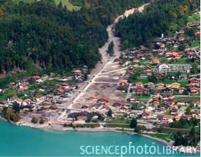 A mudflow through the town of Brienz, Switzerland in 2005
Source: Michael Szoeny, Science Photo Library, http://www.sciencephoto.com/media/164109/enlarge
A mudflow through the town of Brienz, Switzerland in 2005
Source: Michael Szoeny, Science Photo Library, http://www.sciencephoto.com/media/164109/enlarge
Another water-heavy form of mass movement is a debris flow. Debris flows are liquefied landslides of mixed unconsolidated material that look like flowing concrete. They differ from mudslides in that they transport a wider range of debris, from finer particles, to soil, vegetation, stones and large boulders. Mountainsides that have been stripped clean of vegetation from forest fires are prone to debris flows. Be sure to check out this stunning video of a debris flow in Afghanistan (the video is incorrectly titled—it is not a mudflow!). The debris flow is so powerful it moves boulders as large as SUVs as if they were weightless!
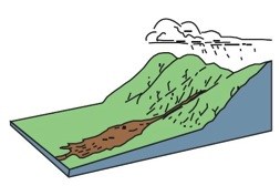 A debris flow can be caused when torrential rains are funneled into a mountain valley
Source: Maine Landslide Inventory Questionnaire, http://www.maine.gov/doc/nrimc/mgs/slide-form.htm
A debris flow can be caused when torrential rains are funneled into a mountain valley
Source: Maine Landslide Inventory Questionnaire, http://www.maine.gov/doc/nrimc/mgs/slide-form.htm
The slide at this EarthCache location is another type of mass movement called an earthflow. In an earthflow, the sedimentary material becomes water-saturated, liquefies, and then runs downslope, forming a bowl at the source area and a fan at the bottom. Earthflows usually occur in fine-grained, clay-bearing slopes. They are an intermediate flow, too fine-grained to be classified as a debris flow, and not wet enough to be considered a mudflow.
To claim this cache: Answer the following questions and send the answers using Geocache's messaging tool.
Q. Using the stratigraphic column provided below, which geologic formation is responsible for this earthflow? Where did the material come from? Visually, how do we know a landslide occurred here and it is not simply a slope of eroded material?
Q. Look at the source area of this earthflow. One could argue that this landslide is a translational slide that occurred along a bedding plane because there appears to be a planar break where the slide originated. What is one on-site fact you could use to refute this argument? (Hint: How are the bedding planes oriented in the surrounding sedimentary rock?)
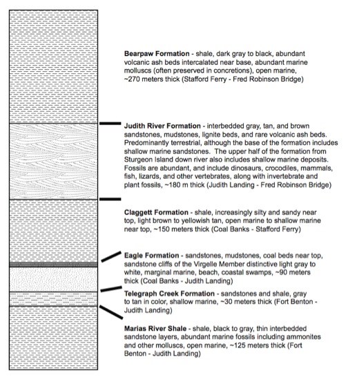 Stratigraphic column of rocks found in the Missouri Breaks
Source: Raymond Rogers, Macalester College Geology Department
Stratigraphic column of rocks found in the Missouri Breaks
Source: Raymond Rogers, Macalester College Geology Department