For more information on floating the river and the first EarthCache in this series, please see this link.
For the next EarthCache in the trail, click here.
-------------------------------
Stop, Hey What’s that Sound? – BOOM – Clinker Beds
Because of the nature of the landscape on this section of the river, some of the EarthCache sites are inaccessible because they are up on cliffs or in places where there are no good landings. Luckily, most of these features are clearly visible at a distance from your canoe. This EarthCache is one of those stops.
As you approach the given coordinates, look up at the ridge on river left. There is a striking red rock that stands out from the rest. If you follow the red bed to the left, you will see that it fades to gray. This gray bed is one of the many coal seams in the Breaks, which are the remains of coastal swamps that once lined the shores of the Western Interior Seaway. These beds are called lignites, also known as brown coal, and are a low-grade coal between peat (partially decomposed plant matter) and true coal.
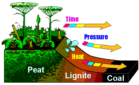 The quality of a coal deposit is determined by the depth of burial under overlying sediment, the temperature and pressure at that depth, and the length of time the coal has been buried
Source: Public Domain, http://kampsenergy.blogspot.com/2012/01/coal.html
The quality of a coal deposit is determined by the depth of burial under overlying sediment, the temperature and pressure at that depth, and the length of time the coal has been buried
Source: Public Domain, http://kampsenergy.blogspot.com/2012/01/coal.html
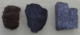 From left to right: peat, lignite, and coal
Source: Christoph Geiss, Trinity College, http://www.trincoll.edu/~cgeiss/courses/mamo/coal.htm
From left to right: peat, lignite, and coal
Source: Christoph Geiss, Trinity College, http://www.trincoll.edu/~cgeiss/courses/mamo/coal.htm
The red beds, which you may have seen earlier on this stretch of the river, are called clinker beds. They form when lightning strikes lignite during a thunderstorm, causing it to ignite and burn. The blaze hardens the rock and leads to oxidization reactions, which bring out the iron in the rock, giving the beds their distinctive red color. The resulting rock is called clinker, the same name for burnt coal (when clinker is knocked together, it makes a “clinking” sound, like ceramic). Clinker beds often cap ridges or knobs because the hardened rock, literally “baked” by flames, is now more resistant to weathering than the surrounding rock, so it slows further erosion. As you float down the river, keep your eyes peeled for other clinker beds that dot the landscape.
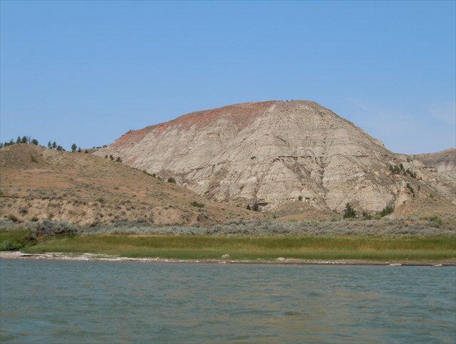 A clinker bed caps a ridge on the Missouri River (Photo by Daniel Morel)
To claim this cache: Answer the following questions and send the answers using Geocache's messaging tool.
Q. What could be another reason why clinker beds are mainly found on ridge-tops and knolls?
Q. How many clinkers can you see from the river before the location of the next EarthCache? For clarity purposes, if there are several right next to each other, just count them as one.