This EarthCache is the first in an EarthCache Trail running from Judith Landing (RM 88.5) to Kipp Recreation Area at the Fred Robinson Bridge (RM 149). RM is ‘River Mile’. These EarthCache sites can ONLY be accessed from the river, and are intended for those floating the Upper Missouri who are looking for a fun and educational geology-scavenger hunt adventure. This 61-mile section of the Upper Missouri River typically requires four days and three nights to float in a canoe or kayak. It is a Class I river, with no significant or dangerous rapids. However, these EarthCaches have a 5-star difficulty because the float requires special equipment (boat, tent, stove, etc.), camping experience and planning ahead. Otherwise, once on the river these EarthCaches are very doable and accessible. Children can certainly come along.
As you travel down the Wild and Scenic Upper Missouri, you will have the opportunity to view firsthand the last undammed portion of this great river, which features outstanding scenery, fascinating geology, and unique plants and animals. The Upper Missouri River Breaks National Monument plays host to a rich cultural history, including Lewis and Clark campsites, Native American heritage areas, old fur trade posts, steamboat landings, and homestead sites. Without a doubt, floating this segment of the Upper Missouri River is one of the premier canoe trips in North America. For more information on planning a float down the river, please call the Missouri Breaks Interpretive Center (406-622-4000) or visit the BLM website.
For the next EarthCache in the trail, click here.
There is also a series of EarthCaches for the upper section of the river, from Fort Benton to Coal Banks landing and for the middle section of the river, from Coal Banks to Judith landing. For this upper section EarthCache trail, click here.
For this middle section EarthCache trail, click here.
---------------------
A Decent Exposure – the Judith River Formation
As you begin your journey and drift away from Judith Landing, you will be greeted by a spectacular panorama of “the Breaks.” This is a local term for the bluffs along the river, carved out as the Missouri cut into the prairie. It is from this feature that the Upper Missouri River Breaks National Monument draws its name.
The rocks here have a rich geological history. Most sedimentary rocks in the Breaks were laid down between 90-70 million years ago in the Western Interior Seaway, an inland sea that once occupied the region and split the continent in two. Geologists have concluded that this narrow ocean paralleled the Rocky Mountain Belt to the east because of marine deposits found adjacent to the Rockies, as well as telling fossils and structures that are only found in ocean environments.
The Judith River Formation (JRF), however, is the only formation in the Breaks that was not laid down in the Western Interior Seaway. The JRF is a mostly terrestrial formation made up of floodplain and river deposits (mudstones and sandstones). The JRF is bound on top and bottom by large shale bodies—the Claggett Formation below and the Bearpaw Formation on top. In general, the shales are darker and form more gradual slopes that are often vegetated, while the JRF is lighter and has more visible layers within it. The Claggett and Bearpaw are both marine shales, laid down in calm, deep parts of the Western Interior Seaway. This tells us that during the shift from the Claggett Formation to the terrestrial JRF, the seaway retreated, exposing land and allowing land-based deposits to accumulate. In geologic terms, this ocean retreat, which is visible in the rock record here as a shift from marine shales to terrestrial sandstones/mudstones, is called a regression. Because the JRF is overlain by the Bearpaw Formation, another marine shale, we know that afterwards the seaway must have advanced, covering what was once floodplains and river channels with ocean sediments. This shift from terrestrial to marine sediments, which reflects an ocean advance, is called a transgression.
 A transgression is an ocean advance; a typical transgressive sequence goes from sandstones to marine mudstones or shales upsection, and sometimes to limestone
Source: Richard Hardwood, Black Hawk College, http://facweb.bhc.edu/academics/science/harwoodr/geol102/Study/images/TransgressiveFacies.gif
A transgression is an ocean advance; a typical transgressive sequence goes from sandstones to marine mudstones or shales upsection, and sometimes to limestone
Source: Richard Hardwood, Black Hawk College, http://facweb.bhc.edu/academics/science/harwoodr/geol102/Study/images/TransgressiveFacies.gif
The Judith River Formation is also of geological and paleontological significance because it contains abundant fossil beds. It is part of a larger rock unit called the Judith River Group, which also has exposures in Alberta and Saskatchewan, Canada. Outside Calgary, the Judith River Group can be found in Dinosaur Provincial Park, one of the richest dinosaur fossil locales in the world. Over 500 specimens have been excavated from forty different dinosaur species. Because of their accessibility, the rock exposures in Dinosaur Provincial Park have been studied and surveyed extensively, while the JRF exposures in the more desolate Missouri Breaks have not. Furthermore, the JRF is slightly older than the other units in the Judith River Group found in Canada, and is not as fossil-rich. The vast majority of fossils in the JRF are microfossils or fossil fragments; there aren’t giant dinosaur bones sticking out of the rocks. Still, there is much to be gained by studying the JRF in the Monument here. In fact, professors from Macalester College are currently working with researchers from the Smithsonian Institution to investigate vertebrate microfossil bone beds in the JRF along this stretch of the Missouri River. They will try to identify species and glean details on how the fossils may have been preserved.
 A mounted Chasmosaurus, a cousin of Triceratops, at the Royal Tyrrell Museum of Paleontology. All specimens of this genus have been unearthed in Dinosaur Provincial Park (Wikipedia Commons)
http://upload.wikimedia.org/wikipedia/commons/8/8e/Chasmosaurus_bellis_RTM_01.jpg
A mounted Chasmosaurus, a cousin of Triceratops, at the Royal Tyrrell Museum of Paleontology. All specimens of this genus have been unearthed in Dinosaur Provincial Park (Wikipedia Commons)
http://upload.wikimedia.org/wikipedia/commons/8/8e/Chasmosaurus_bellis_RTM_01.jpg
Please remember that since this is a National Monument, fossil hunting is illegal. You need an official permit from BLM to collect anything. Microfossils have no significant monetary value, but they are important to researchers, so please leave them be.

To claim this cache: Answer the following questions and send the answers using Geocache's messaging tool.
Q. Now that you’ve learned about transgressions and regressions, look at the stratigraphic column below. Can you identify where else in the rock record (besides above/below the JRF) a transgression and/or regression has occurred?
Q. How many of the formations in the stratigraphic column below are visible in the Breaks around you at this location? What are they?
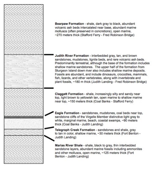 Stratigraphic column of rocks found in the Missouri Breaks
Source: Raymond Rogers, Macalester College Geology Department
Stratigraphic column of rocks found in the Missouri Breaks
Source: Raymond Rogers, Macalester College Geology Department