Please follow the:
If you like this one you may want to try one or more of these.
Map Travel Instructions:
It can be useful to print the map and the worksheets
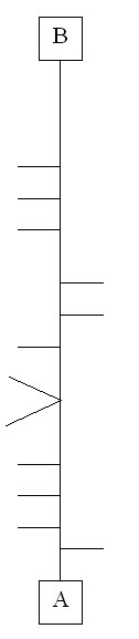
You will travel from point "A" to point "B", following the straight-line map below.
A straight-line map is a simplified drawing of how a mapped route would look if it was a piece of string that was then pulled straight, with all of the connecting paths still attached. The straight line represents the path(s) being traveled at all times (although the actual route will not look anything like the diagram). To the left or right of the central line are "branches" which are instructions for what to do at each intersection.
Path is defined as Blacktop path, concrete sidewalk, painted or unpainted crosswalk.
An intersection for this cache is defined as where:
- Two or more paths meet
- Two or more crosswalks meet
- Access point to path meets the path
The following are excluded: Roads, private walkways or driveways. At no time except for crossing roads does the route go on a road for motorized vehicles.
At each intersection, you must decide to turn left, right or go straight. For example if the branch attached to the center line on the map points left, you must either go straight or turn right . Or if there is a branch on each side, then it is an 4 way intersection and you must go straight through. Two branches on one side also means a 4 way intersection where you must turn.
To find your start location (point "A") go to the posted coordinates. There you will find a a 9 digit number when looking through the glass in 3 sets of 3 numbers.
| ___ |
___ |
___ |
___ |
___ |
___ |
___ |
___ |
___ |
| A |
B |
C |
D |
E |
F |
G |
H |
I |
U = C ___
V = B ___
W = G + I ___
X = D - C ___
Y = F – A ___
Z = B - D ___
| point "A" = |
N41 46. |
___ |
___ |
___ |
W88 06. |
___ |
___ |
___ |
| |
|
U |
V |
W |
|
X |
Y |
Z |
To find the cache, go to point "A" make your heading 78 and then walk to point "B" following the map. Record the total distance you traveled from point "A" to "B" via the route. You will know that you have reached point "B" when shortly after the last intersection you reach the entrance to the playground. Stop your recording on the end block of the southeast wall that surrounds the playground.
Or as herbs2 stated in his log "The Northern most brick in the East wall", if that is easier to understand.
From this spot, you will project the location of the cache.
Distance traveled in miles (round to nearest 1/10th of a mile).
Bearing = (B / 2)___, (B - 1)___, (A + 1)___
Distance = (A)___, (B - 3)___, (B + 3)___, (B + A + 2)___ feet
Since this is more about the journey than finding the cache, you are looking for a cammoed bison attached to a tree.