Velký Špičák (Großer Spitzberg)
I would first like to thank the5013thing for his helpful support and the excellent co-operation.
Geologie / Geology / Geologie
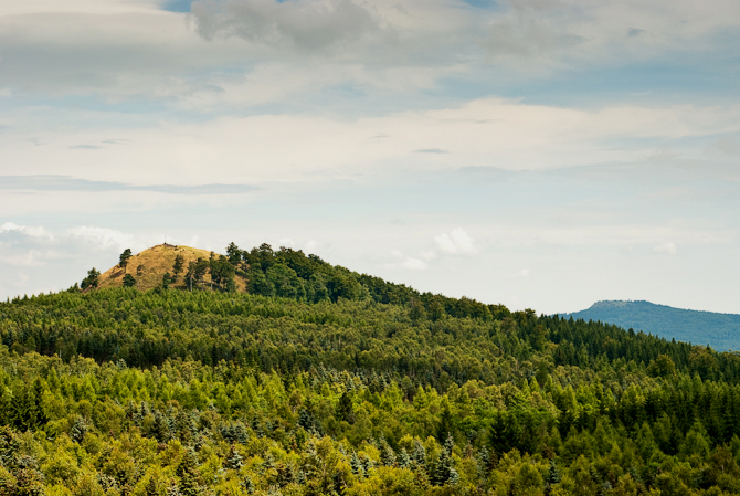
Velký Špičák (německy Großer Spitzberg) je asi 100 metrů široká nezalesněná čedičová klenba, která dominuje místní náhorní plošině. Na jeho vrcholku je kříž s vrcholovou knihou.
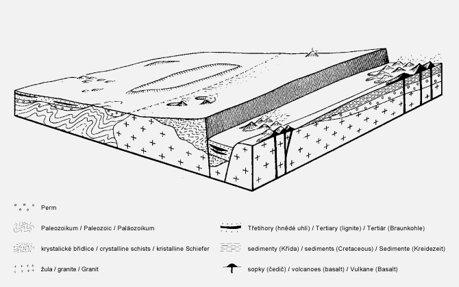
V třetihorách, před třiceti miliony let, byla oblast Krušných hor tektonicky velmi aktivním místem. Vyzdvihování Krušnohorské zemské kry na jižní straně hor a současný propad podkrušnohorských pánví vedly ke vzniku mnohých zlomů v zemské kůře, skrz které mohlo magma vystoupat až na zemský povrch a na mnoha místech podél celé pánve došlo ke vzniku sopečných erupcí (Obrázek č.1). Láva proudila skrz říční údolí k severu a po utuhnutí vytvořila protáhlé čedičové útvary. Čedič podléhá erozi mnohem pomaleji než okolní krystalické horniny, a proto dnes ční nad okolní krajinu několik stolových hor, jakožto pozůstatky původní lávové pokrývky. Jedná se např. o Bärenstein, Pöhlberg a Scheibenberg. Takové erozivní činnosti říkáme inverze reliéfu a vzniklé vyvýšeniny nazýváme také jako svědecké hory.
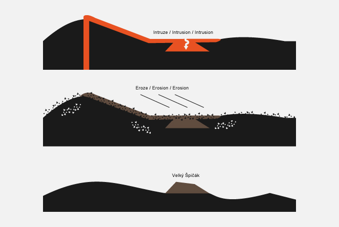
Vznik Velkého Špičáku (Obrázek č.2) se liší od vzniku již zmíněných svědeckých hor. Nejedná se o pouhou efuzi, tedy o povrchový výlev lávy, ale o intruzi, vnik magmatu nebo lávy do vrstvy starších hornin. V našem případě jde o vnik proudu lávy pod zemský povrch, takovému procesu říkáme neovulkanická intruze. Dnes již tato intruze ční nad zemský povrch v podobě čedičové klenby a to je důkaz velmi silné eroze, která postupem času odnesla jak efuzivní lávovou pokrývku, tak okolní horniny. Kromě Velkého Špičáku patří k takovýmto útvarům i Střední Špičák (924m), Malý Špičák (904m) a Jelení hora (994m) (Obrázky č.3 a 5), jejichž hlavní horninou je nefelinit – druh čediče (mapa). U čistě podpovrchových intruzí, které vznikají tuhnutím magmatu bez styku s povrchem, bývá hlavní horninou žula, to ovšem není náš případ, kdy může být intruzivní horninou i čedič.
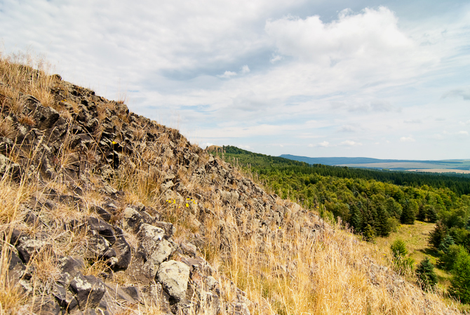
Když láva tuhne, ztrácí na objemu, tímto se vytvářejí trhliny kolmo k ochlazované ploše a vznikají několikametrové čedičové sloupy, též nazývané varhany (Obrázek č.4). Díky otevřenému lomu u Velkého Špičáku je zde patrný právě takový čedič.
ENGLISH
Velký Špičák (Großer Spitzberg) is a 100 meters wide, treeless basalt dome that protrudes from a plateau. At the highest point you can find a summit cross and a summit register.
30 million years ago (Tertiary), the region of Erzgebirge was a tectonically very active area. The raising Ore Mountains clod (Erzgebirgsscholle) in the south and the reduction of Eger rift (Egergraben) caused deep cracks in the earth's crust. Magma rose from these deep cracks. There were many volcanic eruptions along the Eger rift (Figure 1). The lava flowed into the river valleys to the north and formed long bodies of rocks. Basalt weathered slower than the surrounding crystalline rocks. Remains of the basalt flows are significant mountains like Bärenstein, Pöhlberg and Scheibenberg. It was a relief inversion.
The origin of Velký Špičák (Figure 2) is significantly different from the formation of the buttes Bärenstein, Pöhlberg and Scheibenberg. It is not an effusion (outpouring of lava onto the ground), but an intrusion (liquid rock that forms under Earth's surface), which emerges from a lava flow. Lava inflows from the surface into the underlying, existing rock layers. These process is called "neovolcanic intrusion". Today, the intrusion is a basalt dome at the surface, which is an evidence of a very intensive erosion. The effusive part and the surrounding rocks have been eroded over the time. Střední Špičák (924m), Malý Špičák (904 m) and the Jelení hora (994m) have probably the same origin as Velký Špičák (Figure 3,5). They are a part of the same volcanic formation. The main rock of these mountains is nephelinite, a kind of basalt (map). In this case basalt can be an intrusive rock. In other cases, when magma solidifies underground without any contact to the surface, the main intrusive rock is usually granit.
During the cooling of a lava flow, contractional joints or fractures form. While a flow can shrink in the vertical dimension without fracturing, it can't easily accommodate shrinking in the horizontal direction unless cracks form, the extensive fracture network that develops results in the formation of columns (Figure 4). You can see the basalt of Velký Špičák in an open quarry.
DEUTSCH
Der Velký Špičák (Großer Spitzberg) ist eine weitgehend unbewaldete Basaltkuppel, die aus einem Plateau herausragt und nur etwa 100 m breit ist. Am höchsten Punkt befindet sich ein Gipfelkreuz mit einem Gipfelbuch.
Vor 30 Millionen Jahren (Tertiär) war die Region des Erzgebirges ein tektonisch sehr aktives Gebiet. Durch die einseitige Anhebung der Erzgebirgsscholle im Süden und den Einbruch des Egergrabens entstanden tief reichende Verwerfungen in der Erdkruste. Aus diesen tief reichenden Brüchen in der Erdkruste stieg Magma auf. Entlang des gesamten Egergrabens kam es an vielen Stellen zu Vulkanausbrüchen (Abbildung 1). Teilweise floss die Lava in den Flusstälern nach Norden und bildete nach dem Abkühlen langgestreckte Gesteinskörper aus. Da Basalt langsamer verwittert als die umgebenden kristallinen Gesteine, überragen die Reste der Basaltdecken als Tafelberge (Bärenstein, Pöhlberg, Scheibenberg) die Umgebung. Es kam zu einer Reliefumkehr.
Die Entstehung des Velký Špičák (Abbildung 2) unterscheidet sich deutlich von der Entstehung der Zeugenberge Bärenstein, Pöhlberg und Scheibenberg. Es handelt sich nicht um Effusion (ruhiges Ausfließen von Lava), sondern um eine Intrusion (Eindringen von Magma oder Lava in existierende Gesteinsschichten), die aus einem Lavafluss hervorgeht. Dieser drang von der Oberfläche aus in die darunter liegenden, bereits existierenden Gesteinsschichten ein. Den Vorgang nennt man "neovulkanische Intrusion". Heute befindet sich diese Intrusion als Basaltkuppe an der Oberfläche, was ein Beweis für sehr starke Erosion ist. Der effusive Teil und die umgebenden Gesteine wurden im Laufe der Zeit abgetragen. Neben dem Velký Špičák gehört auch der Střední Špičák (924m), der Malý Špičák (904m) und der Jelení hora (994m) zu dieser vulkanischen Formation (Abbildung 3,5). Wie auch der Velký Špičák bestehen diese Berge aus Nephelinit, einer Art von Basalt (Karte). In diesem Fall kann also auch Basalt ein Intrusivgestein sein. Wenn Magma ohne jeglichen Kontakt mit der Oberfläche erstarrt, entsteht meist Granit als Intrusivgestein.
Wenn Lava erkaltet, verliert sie an Volumen. Durch das Zusammenziehen entstehen Risse, die senkrecht zu den Abkühlungsflächen verlaufen. Dabei bilden sich Säulen (Abbildung 4). Durch einen offengelassenen Steinbruch ist der Basalt am Velký Špičák gut sichtbar.
Úkoly / Tasks / Aufgaben
Zalogujte se a pošlete nám odpovědi na otázky č. 1 a 2 přes profil nebo na e-mail teamanuto@gmail.com! Pokud odpovědi nebudou správné, budeme vás kontaktovat. K logu (ne mailem) můžete připojit i fotografii vás nebo krajiny u Velkého Špičáku, není to však podmínkou.
Please log your visit and send us the answers to question 1 and 2 via profile or by mail (teamanuto@gmail.com)! We will contact you if the answers are not correct! A photo of you or the landscape in your log (not in the mail!) would be nice.
Schreibt uns bitte über unser GC-Profil oder per Mail (teamanuto@gmail.com) die Antworten zu Aufgabe 1 und 2! Ihr könnt nach der Einsendung der Antworten sofort loggen! Wir melden uns, wenn etwas nicht stimmt! Ein Foto von euch oder der Landschaft in eurem Log (nicht in der Mail!) ist kein Muss, wäre aber schön.
1. Úkol (lom)
a.) Jakou formu odlučnosti (spoiler) má čedič na Velkém Špičáku (čedičové sloupy v milířovitém uspořádání (a), čedičové sloupy ve vějířovitém uspořádání (b), svislé čedičové sloupy (c))?
b.) Popište krátce čedič na Velkém Špičáku (barvu, strukturu – sloh, texturu – stavbu)!
1. Task (quarry)
a.) Which form of basalt (spoiler) can be found at Velký Špičák (pile-shaped basalt columns (a), fan-shaped basalt columns (b), vertical basalt columns (c))?
b.) Please give a short description of the basalt at Velký Špičák (color, structure, texture)!
1. Aufgabe (Steinbruch)
a.) Welche Absonderungsform (Spoiler) des Basalts liegt hier vor (Basaltsäulen in Meilerstellung (a), Basaltsäulen in Fächerstellung (b), Senkrechte Basaltsäulen (c))?
b.) Beschreibt kurz den Basalt am Velký Špičák (Farbe, Struktur, Textur)!
2. Úkol (vrchol)
a.) Jaká je výška Velkého Špičáku?
b.) Na souřadnicích listingu hledejte vrcholový kámen. Jaký je na něm symbol? Zbytky jaké barvy jsou patrné na kameni?
2. Task (summit)
a.) What's the height of Velký Špičák?
b.) Climb up Velký Špičák and look for the summit stone at the listing coordinates! What symbol can be found on it? The remains of what color can be discovered on the stone?
2. Aufgabe (Gipfel)
a.) Wie hoch ist der Velký Špičák?
b.) Sucht den Gipfelstein an Listing-Koordinaten auf! Welches Symbol befindet sich darauf und von welcher Farbe lassen sich noch Reste entdecken?
Přejeme příjemnou zábavu! Have Fun! Wir wünschen viel Spass:)
Sever / North / Norden > Scheibenberg (807m), Bärenstein (898m), Pöhlberg (831m) Větrné elektrárny - Jöhstadt (Wind Turbines / Windräder - Jöhstadt)
Východ / East / Osten > Jelení hora (Hassberg, 994m), vodní nádrž Přísečnice (Dam / Talsperre - Preßnitz)
Jih / South / Süden > Mědník (Kupferhübel, 910m), Vysoká seč (Hoher Hahn, 1006m), Křížová hora (Kreuzstein, 1027m), Meluzína (Wirbelsteine, 1097m), Macecha (Weberberg, 1113m), Klínovec (Keilberg, 1244m), Střední Špičák (924m), Kovářská (Schmiedeberg)
Západ / West / Westen > Větrné elektrárny - Háj u Loučné (Wind Turbines / Windräder - Háj u Loučné), Hinterer Fichelberg (1206m), Fichtelberg (1215m), Přečerpávací elektrárna Markersbach (Pumped Storage Plant / Pumpspeicherwerks - Markersbach)


Obrázek č.1 / Figure 1 / Abbildung 1: Krušnohorský zlom / Ore Mountain escarpment / Erzgebirgsabbruch (Zdroj / Source / Quelle: Otfried Wagenbreth & Walter Steiner: Geologische Streifzüge, Deutscher Verlag für Grundstoffindustrie, Leipzig 1990, S.135)
Obrázek č.2 / Figure 2 / Abbildung 2: Vznik Velkého Špičáku / Emergence of Velký Špičák / Entstehung des Velký Špičák (©anuto)
Obrázek č.3 / Figure 3 / Abbildung 3: Velký Špičák, Jelení hora (994m) (©anuto)
Obrázek č.4 / Figure 4 / Abbildung 4: Čedič / Basalt / Basalt (Střední Špičák, 924m) (©anuto)
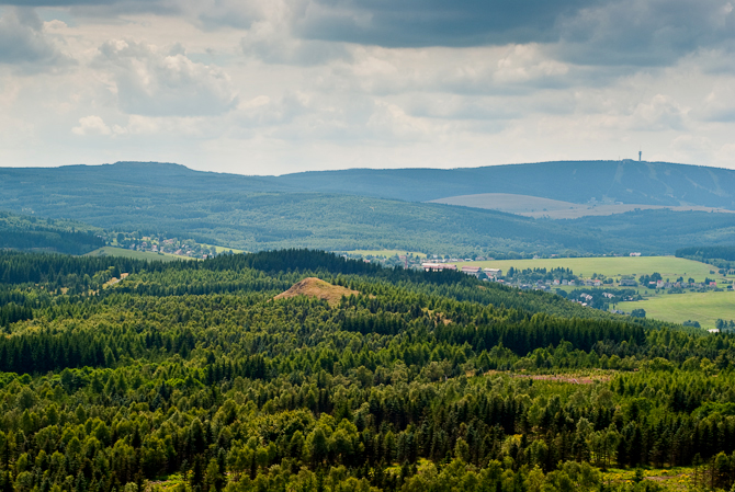
Obrázek č.5 / Figure 5 / Abbildung 5: Střední Špičák (924m), Malý Špičák (904m) (©anuto)
Zdroje / Sources / Quellen: Diercke.de; Geology.cz; Geologieinfo.de; Klett.de; Wikipedia.cz; Wikipedia.de; Otfried Wagenbreth & Walter Steiner: Geologische Streifzüge, Deutscher Verlag für Grundstoffindustrie, Leipzig 1990