For more information on floating the river and the first EarthCache in this series, please see this link.
For the next EarthCache in the trail, click here.
-------------------------------
Joints – Extensional Fractures
This EarthCache is another floater-by. There’s no need to get out of your canoe unless you want a closer look. As you approach the given coordinates, on river left you’ll see a feature that looks like a dark brick wall running parallel to the river. This is an igneous dike cutting through the white Virgelle Sandstone. Both the dike and the sandstone exhibit a geologic phenomenon called jointing. Joints are fractures in rock that form when rock is under extension. Rock near the surface is rigid; when pulled from either side, it cracks, creating a vertical gap in the rock. There is no displacement involved in the formation of a joint—the rocks are not sliding past one another, but rather “popping” apart.
Joints are generally perpendicular to the surface, and occur in sets, with many joints running parallel to one another. The image below is an example of jointed limestone. Be careful not to confuse the joints (running vertically through the rock) with bedding planes, the horizontal pattern in sedimentary rocks that forms as sediment is laid down in layers over time.
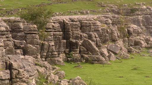 Vertical joints and weathered horizontal bedding planes in limestone
Source: BBC Learning Zone, http://www.bbc.co.uk/learningzone/clips/surface-features-of-upland-limestone-areas/4705.html
Vertical joints and weathered horizontal bedding planes in limestone
Source: BBC Learning Zone, http://www.bbc.co.uk/learningzone/clips/surface-features-of-upland-limestone-areas/4705.html
Most commonly, joints are caused by extensional tectonic stress (a force applied over an area), which is regional stretching of rock. Joints form when the tensile stress applied exceeds the strength of the rock. Imagine prying on a pair of disposable chopsticks: eventually the wood reaches its breaking point and the two sticks snap apart. Rocks behave in the same manner when stretched, and this leads to the formation of joints. This type of jointing is common in sedimentary rocks, particularly sandstone and limestone. Softer rocks, such as shales or mudstones, are less rigid, so rather than fracturing they are able to deform and expand when stretched.
Joints are important, not only because they provide evidence that a rock was at some point under tension, but also because they make rocks more susceptible to weathering, the breakdown of rock at the surface caused by natural processes. Joints and other structural cracks accelerate the process of weathering because they increase the surface area of the rock. They also are the main passageways through which water, air and small organisms can penetrate the interior of rocks. Water facilitates several types of chemical reactions that eat away at rock over time, known as chemical weathering. Water is also the perfect transportation medium to carry away weathered material.
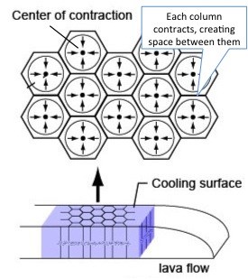
Another type of joints, called columnar joints or cooling joints, form in cooling intrusions of molten rock at depth. This type of jointing differs from the previous one because cooling joints are created at the time of rock formation, rather than later in the rock’s cycle. As intrusive magma cools, it solidifies and contracts, the same way mud in a dry riverbed shrinks and cracks during a drought, forming natural “polygons”. The contraction causes the newly forming igneous rock to fracture, creating joints. As the cracks form, they try to connect together in the most efficient manner possible, which turns out to be a regularly spaced hexagonal pattern (though other shapes can form).
Joints always begin to form at the coolest surface of a magmatic body, and then travel inward (just like a freezing ice cube cools from the outside in). Therefore, joints develop at a right angle to the cooling surface. Generally, in large-scale intrusions, the cooling surface near the Earth’s surface, furthest from the heat of the Earth’s core. In these cases, the joints that form are vertical. As the molten mass continues to cool and solidify into rock, the cracks propagate downward, creating spectacular pillar-like structures (hence the name “columnar” joints). Columnar jointing is responsible for natural wonders such as Devil’s Towel in Wyoming and the Giant’s Causeway in northern Ireland.
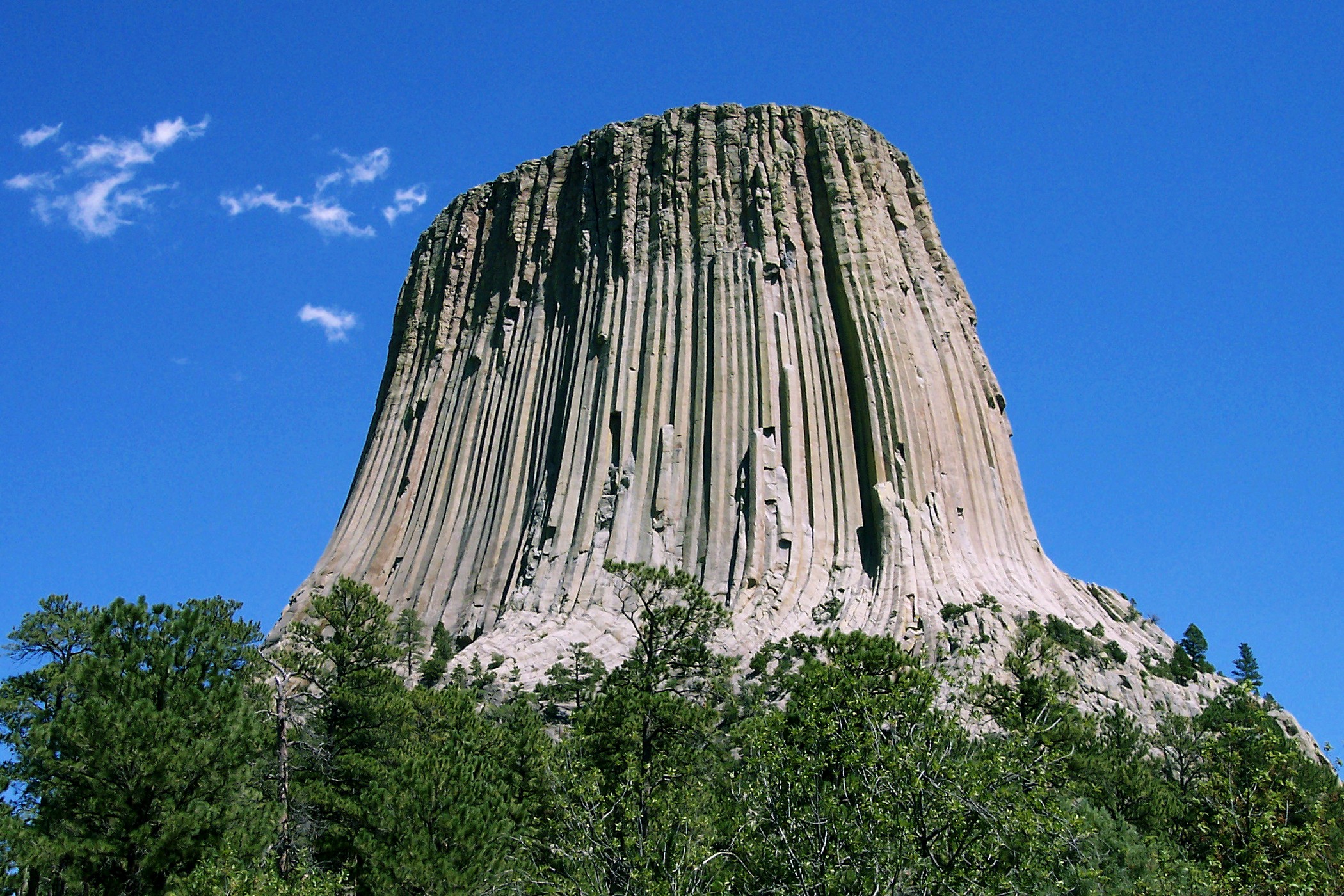 Columnar jointing exhibited in Devil’s Tower National Monument (Wikipedia Commons)
 As the lava cools, it contracts, creating local zones of extension in the newly forming rock, which results in the formation of joints. The fractures are regularly spaced and usually organized in a hexagonal pattern.
Source: Elizabeth Davis, Tessellations in the Eastern Sierra, 2012
As the lava cools, it contracts, creating local zones of extension in the newly forming rock, which results in the formation of joints. The fractures are regularly spaced and usually organized in a hexagonal pattern.
Source: Elizabeth Davis, Tessellations in the Eastern Sierra, 2012
Cooling joints are common in basalt intrusions. However, they sometimes form in other igneous rocks, including shonkinite, the dominant igneous rock here in the Missouri Breaks National Monument. Here in the Breaks, most dikes (vertical sheet-like intrusions of magma that cut across rock layers) are small and narrow. As the intruding magma makes contact with the surrounding walls of the dike, it begins to cool and solidify, slowly cracking toward the center of the dike. If you picture a dike like an upright book, the magma would cool first at the cover, and eventually at the inner pages of the book. In dikes, the joints still form perpendicular to the cooling surface, but since the cooling surface is vertical (the walls confining the dike), the joints that form are horizontal, rather than vertical like in large-scale intrusions. This can make a well-exposed dike appear as if it is constructed of stacked bricks. For this reason, the picturesque jointed dike at river mile 56.9 (just below the Eagle Creek campground) is known as the Grand Natural Wall.
To claim this cache: Answer the following questions and send the answers using Geocache's messaging tool.
Q. How do you think the joints formed in the two different types of rock at this site?
Q. What is the overall preferred orientation of the joints in the sandstone? (i.e. horizontal, vertical?)