For more information on floating the river and the first EarthCache in this series, please see this link.
There is also a series of EarthCaches for the lower section of the river, from Judith to Kipp Landing. To continue onto this EarthCache trail, click here.
-------------------------------
Hoo Doo Dun It? – Hoodoos at Slaughter Creek
This EarthCache involves a short walk, about 30 minutes roundtrip, from the Slaughter Creek campsite. It’s great to do at dusk because there can be spectacular sunsets at the site, and the wind usually keeps the mosquitoes at bay. The path to this EarthCache begins on the upstream side of the campsite, at the coordinates N 47º43.072, W 109º51.041, where there is a gate that will let you through the barbed wire fence. Please close it behind you, as it prevents cattle from getting into the campsite. Walk slowly and keep an eye (and ear) out for rattlesnakes, as well as prickly pear cacti.
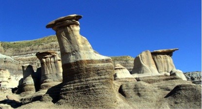
The structures you see at this site are called hoodoos, and yes, that is a geologic term! The name hoodoo was brought to America by slaves from Africa. They called a particular type of magic “hoodoo.” The Blackfeet Indians used the word to refer to the tall rock spires, which they mentioned in myths. Explorers of the West heard the Blackfeet’s description of these strange formations, and that is how “hoodoo” came to be a geologic term applied to such columns of rock.
All rocks on the Earth’s surface are susceptible to weathering, the chemical and physical breakdown of rock exposed to the elements, which involves air, water, and biological activity. Hoodoos are the result of constant weathering and erosion. Erosion is the process by which rock is weathered and subsequently transported away from its source (for a review on weathering and erosion, visit here.).
The top of a hoodoo is “capped” by a stronger rock, aptly named cap rock. This more-resistant cap rock protects the softer sandstone layers beneath it from erosion, which results in the characteristic mushroom shape of hoodoos. Sometimes, the cap and stem of a hoodoo are two different types of rock, for example a limestone cap shielding a stem of weaker sandstone. But here in the Breaks, the cap and stem rock is the same; what differs is the cement that holds the sand-size particles together. The darker cap rock is cemented by rust-colored hematite (an iron oxide mineral), while the lighter-colored stems of the hoodoos are held together by calcite (a carbonate mineral), which is more susceptible to erosion. Sandstone of both compositions (the mineral and chemical make-up of the rock) is common in area, making hoodoos a widespread feature in the Monument.
 Hoodoos in the badlands near Drumheller, Alberta (Wikipedia Commons)
Take a look at the cap rock on these hoodoos. They exhibit a very clear example of a sedimentary structure called cross bedding or cross stratification, which form during sediment deposition. Cross beds are angled beds of sediment packed between horizontal layers that reflect the transport of sediment. When particles are moved along by wind or water, they tend to collect in ridges and form ripples, or on a larger scale, dunes. Cross beds convey paleocurrents, the direction of water or airflow at the time of deposition. The paleocurrent can be inferred by the direction in which the cross beds are inclined. In this case, the cross beds exhibit bidirectional flow, since they are angled in opposite directions. This is indicative of a tidal environment. This unique type of cross bedding is called herringbone cross bedding.
The hoodoos at this site reveal the dynamic, ever-changing nature of the Earth’s surface. You may have noticed the white sandstone rocks exposed on the other side of the coulee, or in the White Cliffs upriver. That same sandstone is found in the stems of these hoodoos. This tells us that the sandstone layer once covered the surrounding landscape. Over time, water draining down this coulee and into the Missouri River probably eroded the rock and swept it away. Today, only the hoodoos remain as evidence that the sandstone layer was once here.
As a side note, while crossing the dry riverbed to reach the hoodoos, you may have noticed some odd looking balls of dirt lying on the ground. These are called armored mud balls. They form in streams during periods of low flow, towards the end of rainstorms. Silt and clay particles moving along the riverbed clump together, eventually forming balls of mud. The mud balls then roll along and continue to grow, just like a snowball. Mud balls often incorporate any loose pebbles they come into contact with, which creates an outer coating of gravel. This is how the mud balls gets their “armored” namesake.
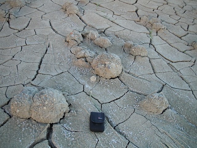 Armored mud balls at Slaughter Creek (Photo by Daniel Morel)
To claim this cache: Answer the following questions and send the answers using Geocache's messaging tool.
Q. How many hoodoos are at this site?
Q. What is the height/thickness of the cap rock in these hoodoos?