For more information on floating the river and the first EarthCache in this series, please see this link.
For the next EarthCache in the trail, click here.
-------------------------------
Intrusions and Metamorphic Rock
In EarthCache #2, we introduced igneous rocks and volcanic plugs. However, volcanic plugs are not the only kind of intrusions (masses of igneous rock that form when magma cools and solidifies below the surface). Two other common intrusions are dikes and sills. A dike is a vertical or near-vertical sheet intrusion that cuts across existing strata. A dike forms when magma forces its way along a crack in the rock.
A sill is a horizontal or near-horizontal sheet intrusion that follows bedding planes and does not cut across strata. Sills are usually more rare than dikes because the magma must have enough fluid pressure to actually lift the weight of the overlying material to make room for the magma to flow horizontally. If magma continues to be pumped into a sill, the top may bulge upwards in the shape of a sand dollar, almost like a pimple, forming a laccolith. Square Butte and Round Butte by the Highwood Mountains are examples of laccoliths in the Missouri River area.
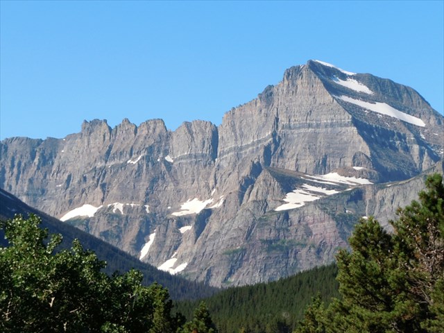 A sill intrudes along the Helena Formation in Glacier National Park, MT (Photo by Daniel Morel)
 Common igneous intrusions and features
Source: Jürgen Schieber, Indiana University, http://www.indiana.edu/~geol105/
Common igneous intrusions and features
Source: Jürgen Schieber, Indiana University, http://www.indiana.edu/~geol105/
Like in the above photo of a sill, sometimes only one side of an igneous intrusion is visible in a flat rock outcrop. In these cases, it is important to remember that dikes and sills are planar features that cut through the Earth’s crust, which require some 3D spatial visualization. They are not just linear intrusions! The igneous intrusion at this location demonstrates this very well.
Here in the Missouri Breaks National Monument, many dikes and sills are composed of shonkinite, a dark-colored, potassium-rich igneous rock with abundant biotite and augite mineral grains (for more on shonkinite, see EarthCache #2). Like most igneous intrusions, the dikes and sills here are resistant to weathering, and overtime they are exposed as the surrounding sedimentary rock is eroded away. As a result, dikes can be seen cutting across the landscape in satellite or aerial photos, like the one below. How many dikes can you find? Notice how some dikes disappear under surface material and then reappear elsewhere, like in small tributary valleys where erosion has removed sediment and exposed the dike.
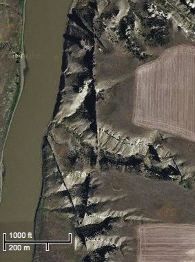 Source: Google Maps Satellite imagery; a section of the Upper Missouri River
At the given coordinates, one of the aforementioned igneous intrusions should be clearly visible straight ahead. If you look carefully, the rock immediately adjacent to the feature appears to be more pure-white in color compared to the surrounding sandstone. It can be hard to get a closer look thanks to Eagle Creek, which often runs high in the spring and early summer, but it seems that the rock has been altered in some manner. That is because this rock is metamorphic rock. Metamorphic rocks are formed when existing rocks are altered by heat or pressure. Metamorphism means “change in form.” Usually, metamorphic rocks develop at great depth in the Earth’s crust, where rocks are subject to immense pressure from the weight of overlying material, as well as heat radiating from Earth’s fiery core. Metamorphic rocks are also common in mountain belts and convergent plate boundaries, where the force of colliding tectonic plates generates both pressure and frictional heat.
However, metamorphism can also occur near the surface in the absence of pressure. Sometimes intrusions of magma heat the surrounding rock to such an extent that the rock experiences structural changes. This process is called contact metamorphism. At this site, the quartz mineral grains in the sandstone recrystallized upon being heated and grew to form quartzite, a hard, highly resistant metamorphic rock. That is why the rock along this igneous intrusion appears slightly “bleached.” It has been baked into a different type of rock that is resistant chemical weathering.
To claim this cache: Answer the following questions and send the answers using Geocache's messaging tool.
Q. What type of igneous intrusion is visible from the site of the given coordinates?
Q. Using the compass on your GPS, in which cardinal directions is the intrusion approximately running?