For more information on floating the river and the first EarthCache in this series, please see this link.
For the next EarthCache in the trail, click here.
-------------------------------
Concretions
The next three EarthCaches are located around the Eagle Creek campground and provide a perfect opportunity to wander and explore after a day of floating. Eagle Creek is located on private land and is only available to the public through a scenic and access easement coordinated by the Bureau of Land Management (BLM). Please take extra care to Leave No Trace—take only memories and pictures. Because this is private land, there may be cattle grazing in the area.
To find the next two EarthCaches, you will be hiking through a coulee historically called The Narrows. A coulee is a loose geologic term with varying regional meanings, though it is usually used to refer to a water-related landform or creek. Here in the Great Plains, a coulee is a kind of valley or ephemeral (temporary) drainage. Please note that coulees can flash flood during and after rainfall events with little warning, so only proceed into the Narrows if it is a clear day. If it rained earlier, make sure that the riverbed is now dry.
Coulees range from broad valleys to tight slot canyons. Regardless of their shape, they all formed through the same process: erosion. Torrential rains sweeping across the Plains have scoured away sediment over time, carrying it into the Missouri. Coulees with steep slot canyons like The Narrows were probably created because rainwater exploited pre-existing fractures in the rock, focusing the erosive power of the surface runoff into a confined space.
Some people state that coulees were sculpted by torrents of glacial meltwater as glaciers retreated from the region about 10,000 years ago. However, these claims are probably false thanks to a few steps of clear reasoning: Geologists know that the Missouri River was rerouted into its current channel by glaciers coming from the north. At the glacier’s greatest extent, the Missouri flowed around the margins of the ice. If glacier meltwater were truly responsible for the formation of the coulees we see today, we would expect most of the coulees to be located on the northern or eastern banks of the Missouri, since that would be the source of the meltwater. The Google Maps satellite photo below, however, clearly demonstrates that coulees flow into the Missouri from all sides, and so it would seem the glacial meltwater theory is flawed. Furthermore, simply by looking at the present Missouri River valley and the extent to which the river has incised into the Plains, there is no doubting the strength of ordinary rainwater-derived erosion. It is easy to imagine similar processes, just on a smaller scale, carving out the coulees along the banks.
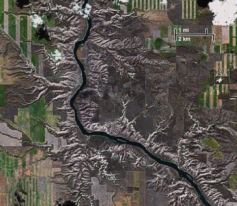 Coulees flow into the Missouri from all sides, refuting the glacial meltwater hypothesis
Source: Google Maps Satellite imagery
Coulees flow into the Missouri from all sides, refuting the glacial meltwater hypothesis
Source: Google Maps Satellite imagery
As you enter the Narrows, you may notice many bumps sticking out of the rock. These hard, compact spheres of sedimentary rock are called concretions. Concretions are formed by minerals dissolved in groundwater migrating toward some “nucleus,” an object in the rock such as a shell, piece of wood or fossil. The dissolved minerals then precipitate (form a solid from a solution), creating a hard sphere or disk-shaped mass around the object. Concretions are usually more resilient than the sedimentary rock they form in, so over time the concretions are exposed as the surrounding rock is worn away by erosion. Here in the Breaks, concretions are cemented by hematite, an iron-oxide mineral that is more resistant to weathering than the calcite cement holding together the surrounding sandstone. Keep an eye out for rounded concretions scattered along the riverbed as you walk up the coulee.
Experts actually don’t know exactly how concretions form. Some theorize that it all starts with small amounts of iron, possibly associated with the nucleating object, which acts like a magnet, attracting other ions of iron in the groundwater flowing through the rock.
 Concretions form as a result of minerals dissolved in groundwater precipitating around a nucleating particle, such as a piece of wood, shell, bone, or fossil (Source: Magnificent Journey, Otto L. Schumacher and Lee A. Woodward, 2004).
To claim this cache: Answer the following questions and send the answers using Geocache's messaging tool.
Q. There is a small bowl in the canyon wall on the left, about a third of a mile into the coulee, where there are many holes in the sandstone rock. What do you think these holes are and how did they form? If you hit a fork in the coulee (or the next EarthCache site), you’ve walked too far.
Q. Are the concretions here uniform or of varying size and shape? Give a brief description of the concretions you see.