For more information on floating the river and the first EarthCache in this series, please see this link.
For the next EarthCache in the trail, click here.
-------------------------------
Cross beds in a Cliff
A landmark for this EarthCache is a block of white sandstone directly at river level on river left. The Eagle Creek sandstone here is the same rock forming the magnificent White Cliffs upriver, which were laid down on the shores of the Western Interior Seaway millions of years ago. Park your canoe on the downstream side and then walk along the bank upriver until you reach the coordinates or see the feature described below on a steep sandstone rockface.
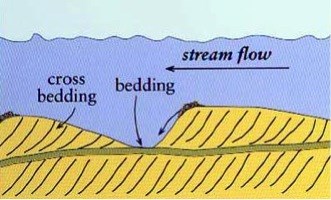
You may notice an odd pattern in some of the rocks before you. This pattern is called cross bedding or cross stratification. Cross beds are angled beds of sediment packed between horizontal layers, which reflect the transport of sediment. When particles are moved along by wind or water, they tend to collect in ridges and form ripples, or on a larger scale, dunes. Regardless of their size, most ripples and dunes share a similar geometry. As the particles move in the predominant direction of the wind or water current, they migrate up the slight incline on the back of a ripple or dune (the upwind or upcurrent side). Eventually, the crest of the ripple becomes unstable (at what is called the angle of repose of the material; for sand, this is about 34º) and particles slide down the steeper downwind/current side. Each inclined surface in a set of cross beds reflects one such “avalanche” of material. Alternatively, in wind-formed dunes, sand particles can also settle in the calm area behind a dune. Cross bedding is an example of a sedimentary structure, a visible feature or pattern in sedimentary rock that formed during sediment deposition. At this particular site, the cross bedding is “highlighted” by bands of iron oxide.
 Sand particles migrate up the back of a dune and are then deposited on the down-wind side
Source: Jeremy Dunning, Indiana University, http://www.indiana.edu/~geol116/
Sand particles migrate up the back of a dune and are then deposited on the down-wind side
Source: Jeremy Dunning, Indiana University, http://www.indiana.edu/~geol116/
Cross beds are important because they indicate paleocurrents, the direction of water or airflow at the time of deposition. The current direction can easily be inferred by the direction in which the cross beds are inclined, as illustrated by the graphic below:
 Source: Rod Benson, http://formontana.net/hoodoo.html
Although cross beds are found almost exclusively in sandstones, they can form in various environments, including aeolian (wind-driven) settings, river channels, and coastal areas. Luckily, cross beds can provide clues to their particular depositional environment because different types of cross beds form under different conditions. For example, large-scale cross beds, on the order of meters thick, indicate past aeolian environments: vast deserts or coastal regions where wind drove large sand dunes across the dry landscape, leaving cross bedding behind.
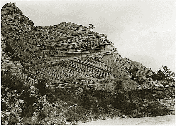 Aeolian cross beds in Zion National Park, Utah (Wikipedia Commons)
Smaller scale cross beds all angled in the same direction are the result of rivers, which have a dominant, unidirectional current. Fluvial is a word geologists use to convey the involvement of a river, such as “fluvial sediments” or “fluvial cross beds.”
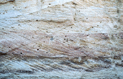 Fluvial cross beds
Source: SEPM Strata, Society for Sedimentary Geology, www.sepmstrata.org
Fluvial cross beds
Source: SEPM Strata, Society for Sedimentary Geology, www.sepmstrata.org
Sometimes cross beds indicate currents moving in opposite directions, which is known as bidirectional flow. These are called herringbone cross beds, thanks to their resemblance to the vertebrae of the herringbone fish. Bidirectional water flow may seem very counterintuitive, if impossible. However, it is actually indicative of a very particular depositional environment: tide-dominated coastlines or tidal channels, where the direction of flow can change due to the ebb and flow of the tidal cycle. Herringbone cross beds are very helpful because they can help verify that a sand formation is marine in origin, rather than terrestrial.
To claim this cache: Answer the following questions and send the answers using Geocache's messaging tool.
Q. Are the cross beds at this site unidirectional? What is the dominant type of cross-bedding present here?
Q. What type of sedimentary depositional environment do these cross beds indicate? Does this environment agree with what you know about the area’s geologic past? (Hint: review the previous EarthCache!)