


Point of view
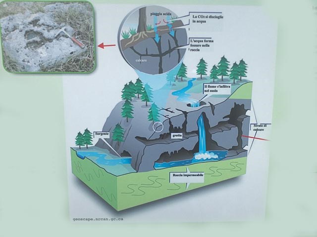
 Karst topography is a geological formation shaped by the dissolution of a layer or layers of soluble bedrock, usually carbonate rock such as limestone or dolomite, but has also been documented for weathering resistant rocks, such as quartzite given the right conditions. Due to subterranean drainage, there may be very limited surface water, even in the absence of any rivers and lakes. However, distinctive karst surface features may be completely absent where the soluble rock is mantled, such as by glacial debris, or confined by one or more superimposed non-soluble rock strata. Some karst regions include thousands of caves.
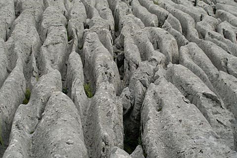
The formations we can see all around are the results of thousands of years of corrosion and erosion. On the surface of the rocks there are various morphological formations, one of them being kamenitza. The crevices of the rocks contains water, which dissolves the surface of the rock, enlarges the crevice an creates a new geological form. Another morphologiacal shape found in karst areas are parallel vertical grooves causes by rain or running water known as rinnenkarren or rillenkarren. The exposed limestone surface sometimes resembles tiny, choppy waves with hundreds of sharp peaks.

Kamenitza
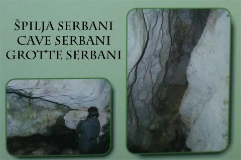
The water pentrates into the crevices and gaps of the rocks and slowly dissolving them, forms cavaties, wells and galleries. In this way caves are formed. The "Spilja Serbani / Cave Serbani" is comprised of two large halls linked by a narrow corridor leading southwads towards the entrance. Due to the research up till now this cave is an extraordinary underground site with relatively intact stratified rock, but to date it has seldom been frequented.
To log this earthcache please answer this three questions:
1. What ist "Dinaric calcareous"?
2. How long is the "Cave Serbani"?
3. At STAGE2 you find three Informations-Boards. Look at the board in the north -> What happened at this place 65 million years ago at the end of the Cretaceous and what kind of sea life (the name!) was involved?
Send your answers to . If everything is correct, you get the permission to log. Every cacher would be happy, about a photo of you with the Mirna valley in the background:-)
Info Karst
 Unter Karst versteht man in der Geologie und Geomorphologie unterirdische und oberirdische Geländeformen in Karbonatgesteinen (zum Teil auch in Sulfat- und Salzgesteinen), die vorwiegend durch Lösungs- und Kohlensäureverwitterung sowie Ausfällung von biogenen Kalksteinen und ähnlichen Sedimenten mit hohen Gehalten an Calciumcarbonat entstanden sind. Hauptmerkmal ist der überwiegend unterirdische Wasserhaushalt, der nicht auf einer primären Porosität des Gesteins beruht, sondern vielmehr sekundär durch den in geologischer Zeit stattfindenden Prozess der Verkarstung (d.h. Korrosion) bedingt wird. Dadurch sind Landschaften, die petrologisch überwiegend von Karbonaten aufgebaut werden, als Karstlandschaften ausgebildet.
Es hat Tausende von Jahren gedauert bis sich diese Formen des Karstes, die wir heute bewundern, durch Korrosion und Erosion gebildet haben. Auf der Oberfläche des Felsen entstehen verschiedene morphologische Gebilde, eines davon ist die Kamenitza. In den Felsspalten lagert das Wasser, das den Stein langsam auflöst, die Spalte vergrößert und eine neue geologische Form entstehen lässt. Ein anderes morphologisches Gebilde sind Rillenkarren und Rinnenkarren. Das sind durch Erosion entstandene Furchen und Rillen an der Oberfläche des Felsens. Sie verlaufen parallel zueinander, die Eintiefung ist abgerundet, die Kanten sind oft scharf.
Rillenkarren
Das Wasser dringt in Spalten und Risse ein und indem es in einem langjährigen Prozess die Oberfläche des Felsens zersetzt, entstehen Hohlräume, Schächte, Gallerien. Alle diese Formationen sind in einer Grotte vorhanden. In der hier liegenden "Spilja Serbani / Grotte Serbani" befinden sich zwei große Räume, verbunden mit einem engen schmalen Korridor der südlich zum Ausgang führt. Diese Höhle ist eine bisher wenig beachtete, außergewöhnliche unterirdische Sehenswürdigkeit, mit verhältnismäßig gut erhaltenen, schichtenförmigen Gesteinsformationen.
Die Koordinaten führen euch zu einem sehr schönen abgelegenen Ort mit toller Aussicht. Um diesen Earthcache zu loggen, müßt ihr drei Fragen beantworten:
1. Was versteht man unter "Dinarischem Karst"?
2. Wie lang ist die "Grotte Serbani"?
3. Bei STAGE2 findet ihr drei Informationstafeln. Schaut auf die nördliche Tafel -> Was geschah hier vor 65 Mio. Jahren am Ende der Kreidezeit und welche Meereslebewesen (der Name!) war davon betroffen?
Sendet eure Antworten an . Sofern alles richtig beantwortet ist, erhaltet ihr die Logfreigabe. Über ein Foto von euch mit dem Mirnatal im Hintergrund würden sich alle Cacher freuen:-)
 Krških topografije je geološka formacija oblikovana raspada slojem ili slojevima topivih živoj stijeni, obično karbonatnih stijena, kao što su vapnenca ili dolomita, ali je također dokumentirano za trošenje otpornih stijena, kao što su kvarcita u pravim uvjetima. Zbog podzemne odvodnje, postoji svibanj biti vrlo ograničene površine vode, čak iu nedostatku bilo kakvih rijekama i jezerima. Međutim, osebujna krški oblici na površini može biti potpuno odsutna gdje topiv stijena mantled, kao što je glacijalnog krhotine ili ograničena od strane jednog ili više nadodatim ne topljivih stijena slojevima. Neki krške regije uključuju tisuće špilja.
Postrojbe možemo vidjeti svuda oko su rezultati tisuća godina korozije i erozije. Na površini stijena postoje različite morfološke formacije, jedan od njih bude kamenitza. Pukotine stijena sadrži vodu, koji rastvara površinu stijene, povećava pukotina stvara novi geološki oblik. Drugi morphologiacal oblik nalazimo u krškim područjima paralelne vertikalne utora uzroci po kiši ili tekuće vode poznat kao rinnenkarren ili rillenkarren. Izložena vapnenačku podlogu ponekad podsjeća na malenim naletima valova sa stotinama oštrih vrhova.

fossilization in the karst
Voda pentrates u pukotine i praznine u stijenama i polako ih se otapa, čini cavaties, Wells i galerije. Na taj način nastaju špilje. "Spilja Serbani / Cave Serbani" se sastoji od dvije velike dvorane povezane uskim koridor kojim se ulazilo southwads prema ulazu. Zbog istraživanja do sada to Špilja je podzemna izvanredno mjesto s relativno očuvanom stratificiranom rock, ali do danas to je rijetko posjećuju.
Koordinate vas dovesti do vrlo lijepog i tipični kraški i usamljeno mjesto s predivnim pogledom. Da biste se prijavili ovaj earthcache Molimo da odgovorite na ovu tri pitanja:
1. Što ist "sku krečnjački"?
2. Koliko je "Cave Serbani"?
3. Na STAGE2 ćete naći tri Informacije daske. Pogledajte odbora na sjeveru -> Što se dogodilo na ovom mjestu prije 65 milijuna godina na kraju krede, a što vrsta morskog života (! Ime) je bio uključen?
Pošaljite svoje odgovore na . Ako je sve točno, možete dobiti dopuštenje da se prijavite. Svaki cacher bi bili sretni, oko fotografiju s vama doline Mirne u pozadini :-)