This EarthCache is one of several in an EarthCache Trail that runs along the Missouri River from the Chouteau County Fairgrounds Campground and Canoe Launch (Fort Benton - RM 0) to Coal Banks Landing (RM 41.5). This EarthCache is only accessible from the river. For more information and the first EarthCache in this series, please see the following link: click here.
There is also a series of EarthCaches for the middle section of the river, from Coal Banks to Judith landing and for the lower section of the river, from Judith to Kipp Recreation Area. For this middle section EarthCache trail, click here.
For this lower section EarthCache trail, click here.
----------------------
The Breaks – Introduction and Local Geology
From this point you can see the steep bluffs created by the Missouri River as it cut through the soft sediment over time. It is from this erosional feature, “the Breaks,” that the Upper Missouri River Breaks National Monument derives its name.
As you can see in the Breaks before you, the material making up these rocks were laid down in horizontal layers. This material, and the majority of the rock beneath the prairies in eastern Montana, is sedimentary rock. Sedimentary rock is formed by the deposition of sediment on the Earth’s surface in bodies of water, including rivers, lakes, and oceans. Particles of sand, silt, and clay are distributed by rivers, water currents, and tides until they settle out of the water and form layers of sediment. As new layers accumulate, they compress earlier, underlying layers with their weight and turn them to stone in a process called lithification (from the Greek word “lithos,” meaning stone). When sediments are heavily compacted, the microscopic pore spaces between sediment grains decrease and the water filling these void spaces is squeezed out. Minerals dissolved in the water, such as calcium carbonate or hematite, precipitate and cement the grains together (To precipitate means to be deposited in a solid form from a solution). This completes the process of lithification, the transformation of sediment to sedimentary rocks.
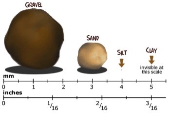
Sedimentology is the study of the origin and properties of sedimentary rock. It is from sedimentology that we obtain most of our scientific knowledge of geologic history, and even the history of life, through fossils preserved in sedimentary rock. For example, much of eastern Montana is underlain by a type of sedimentary rock called shale. Shale is a very fine-grained rock, meaning it is made up of very small particles, called silt and clay. In the scale of grain size, gravels are larger than 2mm, the smallest of sand grains are just visible with the naked eye, and clay grains are less than 5% the thickness of an average human hair!!
 A relative visual scale of sediment grain sizes. Source: The Discovery Channel
http://school.discoveryeducation.com/schooladventures/soil/images/particle_sizes1.gif
A relative visual scale of sediment grain sizes. Source: The Discovery Channel
http://school.discoveryeducation.com/schooladventures/soil/images/particle_sizes1.gif
Since clay particles are so small and light, they are easily suspended in moving water. Consequently, clay particles only settle to the bottom of the calmest water environments with little to no flow, such as the center deep lakes or far off the coast in the undisturbed parts of the ocean. Because of the extensive shale deposits in the West, as well as telling fossils and structures found only in marine environments, geologists have concluded that a large inland sea once occupied the region. Called the Western Interior Seaway, this relatively shallow sea existed from about 100 to 65 million years ago. The narrow ocean corridor was home to abundant marine life and completely separated the continent of North America into two landmasses.
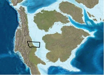 Artist’s rendering of the Western Interior Seaway, ~100-65 million years ago (Ron Blakey, Department of Geology at Northern Arizona University, http://www2.nau.edu/rcb7/namK75.jpg)
It is hard to imagine such a stark difference from today’s landscape, but it was actually made possible by the formation of the Rocky Mountains. The massive weight of the growing mountain belt loaded the Earth’s crust, causing it to subside. This formed a foreland basin to the east, which ran adjacent and parallel to the Rocky Mountains. This narrow, belt-like basin was then subsequently flooded because of high global sea levels at the time, creating the Western Interior Seaway.
Most of the sedimentary rocks that you see in the Upper Missouri Breaks National Monument were deposited, layer by layer on top of one another, in the Western Interior Seaway. As the Rocky Mountains grew, winds and rivers carried loads of sediment off the mountains to the east. The larger, heavier grains of sand were deposited in near-shore environments, while the smaller and lighter grains of silt and clay traveled farther out into the seaway before settling out in calm, deep water. As this deposition continued, sediments laid down earlier were compacted by the immense pressure of overlying material, eventually converting the loose sediments to sedimentary rock. In this manner, sands became sandstone, and silts and clays became shale or mudstone.
Overtime, more and more sediment accumulated, recording the geologic processes occurring on the surface at the time. That is, until about 2 million to 10,000 years ago, during the most recent ice age. Massive continental glaciers flowed south from Canada, sculpting the landscape and carving out sediments deposited in recent times, almost like a bulldozer. Glaciers are the reason why older rocks lie near the surface here, since the overlying younger sediment has been scraped away.
In fact, glaciers are also responsible for rerouting the mighty Missouri River! The river used to flow to the north and discharge into Hudson Bay in Canada. But about 70,000 to 30,000 years ago, the river was pushed south by a continental glacier and was forced to flow around the southern extent of the wall of ice. After the glacier retreated, the Missouri River regained some of its old channel from Great Falls to Loma. Downstream from there, however, it captured another river’s channel, which lead to the Mississippi River. This is where the Missouri River discharges today. This geological shift is actually reflected the topography of the Breaks. Upstream from Loma, the Missouri lies in a textbook example of a broad, mature river valley with smoothed out walls. But further downstream, the river has cut a narrow and steep-walled canyon, which appears to be much younger in origin.
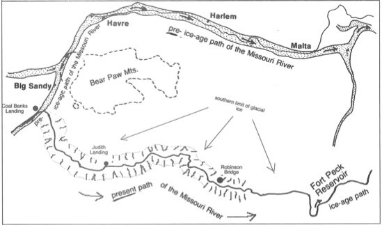 The Missouri River was rerouted by continental glaciers extending from Canada (Source: Montana’s Wild and Scenic Upper Missouri River, Glenn Monahan & Chanler Biggs, 2001).
Today, the Missouri River continues to cut through the sedimentary rock, flowing through time and exposing the sedimentary rocks laid down 90-70 million years ago. According to the Principle of Stratigraphic Superposition, younger sedimentary strata (layers of rock) lie on top of older strata. This principle is well demonstrated by an analogy to a stack of newspapers, laid on top of one another day after day. The bottom paper will be the oldest newspaper, and the top paper will be the most current newspaper.
The graphic below illustrates the major rock layers found within the Upper Missouri River Breaks National Monument. This type of graphic is called a stratigraphic column. A stratigraphic column demonstrates the vertical sequence of sedimentary rocks in a particular area and shows where they are at depth relative to one another. Each rock formation, technically termed a lithostratigrpahic unit, is named after a locale where the rock is well exposed, followed by the rock type. For example, the Telegraph Creek Sandstone. Because the strata in the region dip slightly to the east, older rock formations are exposed in the western part of the Monument. As you float downstream to the east, you travel “upsection” through the rock record, with younger rocks being exposed downriver. Don’t feel the need to scrutinize this stratigraphic column—it’s just there if you want to look at it! In this particular stratigraphic column, some of the rock types are left out of the unit names.
To claim this cache: Answer the following question and send the answers using Geocache's messaging tool.
Q. The oldest rocks in the Missouri Breaks are visible from this point. Use the Principle of Superposition and the stratigraphic column below to determine which two rock formations are exposed in the Breaks across the way. List them from oldest to youngest.
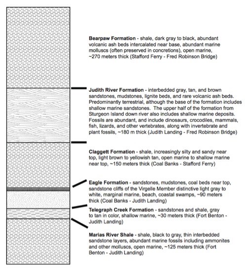 Stratigraphic column of rocks found in the Missouri Breaks
Source: Raymond Rogers, Macalester College Geology Department
Stratigraphic column of rocks found in the Missouri Breaks
Source: Raymond Rogers, Macalester College Geology Department