GLJUFURARFOSS CANYON (ICELAND) EarthCache
GLJUFURARFOSS CANYON (ICELAND)
-
Difficulty:
-

-
Terrain:
-

Size:  (other)
Please note Use of geocaching.com services is subject to the terms and conditions
in our disclaimer.
Short funny walk into the narrow canyon of Gljúfurárfoss.
This cache is part of the KATLA Geopark.
www.katlageopark.is
Gljúfurárfoss is situated in the very near of Seljalandsfoss (see http://coord.info/GC2B1TJ) at the route 249 behind the camping area.
You can park your car at the given parking co-ordinates or leave it at the big parking area at Seljalandsfoss and walk the 500 meters along the bottom of the cliff.
Like its big famous brother Seljalandsfoss the water for Gljúfurárfoss is coming from the glacier Eyafjallajökull through Hamragarðahraun, a lava field formed by former eruptions of the Eyafjallajökull,and falls over the cliff into the plains of the Markarfljót river.
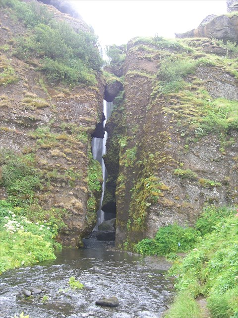
But Gljúfurárfoss looks very different from Seljalandsfoss. While the later is clearly visible from kilometres away, Gljúfurárfoss is hiding itself in a narrow gorge.
Aim of this earthcache is to explain the different types of erosion of the nearby falls. Why have two falls so closed together, coming from the same origin, such a different shape?
Geology
To understand the different kind of erosion at the two places, lets first have a look at the occouring rocks.
1.) The main type of rock is hyaloclastite. "Hyaloclastite is a hydrated tuff-like breccia rich in black volcanic glass, formed during volcanic eruptions under water, under ice or where subaerial flows reach the sea or other bodies of water (wikipedia)".
2.) The other kind of rock in this area is tillite. It consists of rocks of the glacial drift, that means clay from the glacial moraines often containing sands and boulders.
For more information look at http://coord.info/GC2B1TJ, where you can find a detailed description of the occuring minerals in this region.
But while at Seljalandsfoss between the top lava layer from Hamragarðahraun and the hyoclastic layers at the bottom there exist big layers of tillite in the middle, this tillite layers are almost missing at Gljúfurárfoss. You can see this, because if you walk into the Gljúfurárfoss-canyon the walls are black-coloured.
The lackness of this hugh tillite layer is responsible for the different types of erosion of the river falls..
Tillite rocks could easier erode as hyaloclastic rocks.
In the evolution of Seljalandsfoss the water coming from Hamragarðahraun shooted over the hard cliff and landed on the hard bottom and swirled around. The particle carried along by the fluent water like sand or stone hollow out the softer rock on the river ground slowly and lead there to deepening the ground digging away some parts of the cliff wall under the hard top layer. This whirlpool hole becomes bigger and bigger in the course of the time and thus originates the Seljalandsfoss with its overhanging cliff, where you can walk behind.

But in the evolution of Gljúfurárfoss the almost missing tillite layer avoided such a wide erosion. In addition to this Gljúfurárfoss does not lead such an amount of water like Seljalandsfoss. So as little Gljúfurárfoss falled over the cliff it began cutting its way into the harder rocks like a jigsaw forming a really narrow canyon. The word Gljúfurárfoss means river canyon waterfall.
Because only the area where the water passed was worn down, the resulting gap in the earth was very thin and deep. At the beginning of the Gljúfurárfall the river falls over a cliff edge into a deep plunge pool at the bottom, where there were weak levels of tillite rock which have been excavated more quickly than that overlying rock. The force of the swirling water around the rocks causes hydraulic action and abrasion which deepens the plunge pool. This leads to the undercutting of overlying rocks, this rock eventually collapses and the waterfall goes upstream leaving a gorge ahead of it. There occurs only degradation, no side erosion.
Therefore the riverbed of the Gljúfurárfoss gorge is enclosed by nearly vertical, partly overhanging walls. The water hit a lane through the hard rocks with real power, without eroding the side walls. Due to the hard hyaloclastic rocks the side walls did not erode much.
In addition to this in the narrow gorge developed a micro clima. Cold weather causes water trapped in tiny rock cracks to freeze and expand, breaking the rock into several pieces. This leads to gravity erosion on steep slopes. The scree which forms at the bottom of a steep mountainside is mostly formed from pieces of rock (soil) broken away by this means.
Your path
Enter the canyon at the listing co-ordinates.
At the right side of the gorge's wall there is a little path with stones in the river so that you might enter the canyon without getting wet shoes. My son and I entered with plastic shoes which could get wet but the water is really refreshing.
Protect your camera! You won't get drowned because on the right side of the canyon's wall are some niches which hide you from spray. Put your camera under your shirt that might be sufficient. Everythink at your own risk.
Enter the canyon, go to the waterfall! And have fun!
And here are our tasks:
Before online-logging send the anwsers to the following questions via geocaching profil to us:
1.) Estimate the width of the canyon at its entrance, the length of the entrance to the fall and the altitude of the fall.
2.) How many niches are on the right canyon wall while walking to the fall?
3.) At the end of the canyon just before the fall there is a hugh boulder. By the information given above explain in simple words how do you think it came to this place! It is made of the same material like the canyon walls?
4.)Under the assuption that the cliff is about 700000 years old and that the erosion in this gorge was constant calculate the number of years which erosion needs to lenghten this canyon for 1 centimeter.
5.) Edit 2.8.21: Foto-upload of you, part of you, your GPSr... in your online-log is required (re-allowed by GC since June 2019)
And we would love to see nice pictures of you in the Gljúfurárfoss canyon and share your story.
You can log online directly after sending the mail without wating for log-permission.
Logs without the required e-mail will be delete.


Additional Hints
(Decrypt)
Cebgrpg lbhe pnzren!