Přírodní park Jesenicko na západě okresu Rakovník zasahuje i na okresy Louny a Plzeň – sever. Pro svoji klidnou, vyváženou krajinu a přírodní zajímavosti bylo Jesenicko vyhlášeno nejprve klidovou oblastí (v roce 1987), později přírodním parkem (1994).
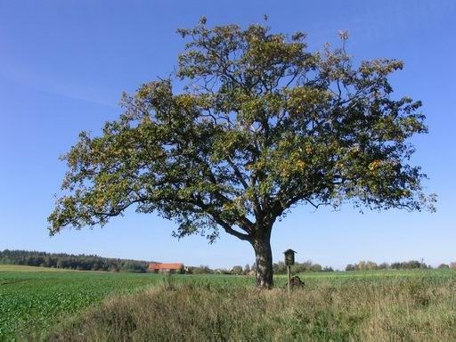
Jesenicko je kus malebné, klidné, harmonické, převážně zalesněné krajiny s rybníky a zelenými údolími, bizarními skalními útvary, malebnými zatopenými lůmky, mokřady a historicky pozoruhodnými vesničkami. Území má velkou estetickou a krajinářskou hodnotu.
Od Rakovníka se Jesenicko jeví jako lem zalesněných pahorků nad Rakovnickou kotlinou, od karlovarské silnice jsou vidět scenerie romantických vrchů v okolí Petrohradu. Na západě se za polnatou nížinou zvedá zalesněná okrajová hrana Rabštejnské pahorkatiny. Jesenicko je ostrovem uprostřed zemědělské krajiny.
Členitá pahorkatina Jesenicka nabývá místy až plošně vrchovinný ráz. Nejvyšší body přesahují nadmořskou výšku 600 m (Lhotský a Plavečský vrch).
Jesenicko tvoří málo rozčleněná kra, kterou na severu a východě výrazně omezují zlomové svahy, zatímco na jihu a z části na západě je přechod do okolí plynulejší. Malá hloubková eroze se výrazněji projevuje jen v údolí Rakovnického potoka, kde při východním okraji oblasti tvoří výrazný zářez s výškovým rozdílem okolo 100 m. Široká úvalovitá údolí se pohybují v rozmezí 430 - 470 m, nejnižší bod oblasti se nachází u Kryr - 308 m n. m. Dno hluboce zaříznutého údolí Rakovnického potoka u Oráčova klesá na 380 m n. m.
V Jesenici jsou spousty možností ubytování, od hotelů po chatkové, či stanové campy. Odtud se pak hezky vyráží na spousty zajímavých výletů do okolí.
Naturpark Jesenicko
 Der Naturpark Jesenicko im westlichen Bezirk von Rakovnik mischt sich auch mit anderen Bezirken wie Louny und Plzen ein – im Norden. Jesenicko wurde für seine ruhige, ausgewogene Landschaft und für seine natürliche Sehenswerte als ein Ruhebereich (in 1987), später als Naturpark (1994) erklärt.
Jesenicko es ein Teil der malerischen, ruhigen, harmonischen, teilweise bewaldeten Gegend mit Teichen und grünen Täler, bizarren Felsenformen, malerischen überschwemmten Steinbrüchen, Feuchtgebieten und historischen eindrucksvollen Dorfe. Dieses Gebiet hat einen ästhetischen und landschaftlichen Wert.
Von Rakovnik scheint Jesenicko als ein Saum von bewaldeten Bergen über Rakovnik Talkessel, von Karlsbadstrasse kann man Szenario von romantischen Spitzen in der Nähe von Petrohrad sehen. Im Westen steigt hinter dem Feldtiefland die bewaldete Kante von Rabstejn Hügelland. Jesenicko ist eine Insel in der Mitte von der landwirtschaftlichen Gegend.
Das aufgeteilte Hügelland von Jesenicko nimmt an einigen Plätzen bis zu steilen Geraden zu. Die Hochpunkte haben mehr als 600 Meter über den Meeresspiegel ( Lhotsky und Plavecsky Hügel)
 Jesenicko bildet etwas wenig von geteilten Schollen, die im Norden und im Osten ziemlich steilen Abhang. beschränkt. Andererseits im Süden und teilweise im Westen ist der Übergang in die Umgebung fliessend. Eine klein tiefe Erosion erscheint etwas mehr nur im Tal von Rakovnik Fluss, wo im östlichen Rand des Gebietes ein ausgeprägter Schnitt von Höhenunterschied rund um die 100 Meter bildet. Breite Tale bewegen sich zwischen 430 – 470 Meter, der tiefste Punkt des Gebietes befindet sich bei Kryr (308 Meter über den Meeresspiegel). Der Untergrund des tiefen Tales von Rakovnik Fluss bei Orac sinkt bis auf 380 Meter.
In jesenicko gibt es viele Angebote von Unterkünften, von Hotels bis Hütten- oder Zeltcamps. Vonhier kann man interessante und schöne Ausflüge machen.
The national park
Jesenicko
The national park Jesenicko in the west of district Rakovník extends into districts Louny and Plzeň-sever. For its calm and balanced countryside and natural curiosity Jesenicko was declared the national reservation (in 1987), later the national park (in 1994).
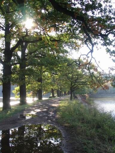 Jesenicko is an area of picturesque, calm, harmonious and mostly wooded countryside with ponds, green valleys, bizzare rock formation, scenic swamped quarries, wetlands and historical extraordinary villages. This territory has a large esthetical and landscape value.
From Rakovník Jesenicko looks like a strip of woody hilly country over Rakovnická kotlina, from Karlovarská road it is possible to see scenery of romantic hills in the vicinity of Petrohrad. In the west, behind lowland field, wooded edge of Rabštejnská hilly area is rising. Jesenicko is an island in the middle of agricultural area.
A rugged hilly country of Jesenicko acquires even widely highland character.The highest hilltops exceed 600m of height above the sea level (Lhotský and Plavečský vrch).
Jesenicko is composed of articulated floe, which is in the north and east markedly bordered by fragmented sloupes. A shallow erosion is more visibly manifested only in valley of Rakovnický potok, where near eastern border of the region forms a marked notch with height difference around 100m. Wide valleys are 430-470m wide, the lowest point of the area is located near by village Kryry – 308m above the sea level. Floor of deeply cut in valley of Rakovnický potok near by Oráčov falls to 380m a.s.l.
There are numerous possibilities to find accommodation, from hotels, to cottage or tent camps. From here tourists can set out on a trip to many interesting destination in the area.
_________________________________________________________________________
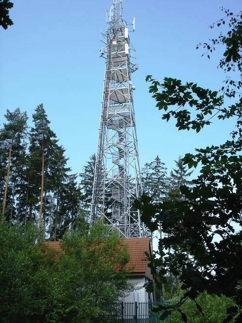 Rozhledna Tobiášův vrch
4 km severně od Jesenice. Vyhlídka na Rakovnicko a panorama severozápadních Čech (Doupovské hory, Krušné hory, Džbán, České středohoří. V roce 2012 otevřeno od 19. 5. do 30. 9. Z Jesenice dostupná oklikou po turistických trasách přes Kosobody (8 km) nebo Petrohrad (10 km) nebo přímo po silnici II/27 (parkování 300 metrů od rozhledny).
Aussichtspunkt von Tobiashügel
Vier Kilometer nördlich von Jesenice gibt es eine Aussicht auf Rakovnicko und das Panorama von nordwestlichem Tschechien. (Doupovske Bergen, Erzgebirge, Krug, tschechisches Mittelgebirge) Im Jahr 2012 ist es von 19.Mai bis 30. September geöffnet. Von Jesenice erreichbar dank den touristischen Wanderwegen über Kosobody (8km) oder Petrohrad (10km) oder direkt über der II/27 Strasse. (Parkplätze sind 300 Meter vom Aussichtspunkt entfernt)
The lookout tower Tobiášův vrch
4km north of Jesenice. A view over Rakovnicko and panorama north-western Bohemia (Doupovské hory, Krušné hory, Džbán, České Středohoří). Opening time in season 2012 is from 19.May till 30.September. The tower is accessible by roundabout way via turistic routes thorough Kosobody (8km), Petrohrad (10km) or directly on the road II/27 (parking 300m from the lookout tower).
Trosky hradu Petrohradu
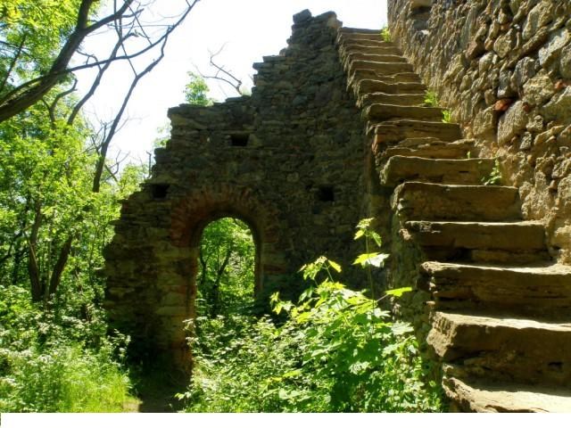
Ruiny středověkého hradu s vyhlídkou na panorama severozápadních Čech. Na vrchu Všech Svatých 3 km severozápadně od Jesenice. Dostupné z Jesenice po turistických trasách (4 km).
Die Ruinen der Burg Petrohrad
Von diesen Ruinen hat man auch eine Aussicht auf die nordwestliche Tschechische Republik. Der Hügel von allen Heiligen ist 3 Km von Jesenice erreichbar dank den 4km langen Wanderwegen.
Ruins of castle Petrohrad
Ruins of medieval castle with outlook on panorama of north-west Bohemia. On the summit „Všech svatých“, 3km north-westwards from Jesenice. Accessible from Jesenice using turistic routes (4km).
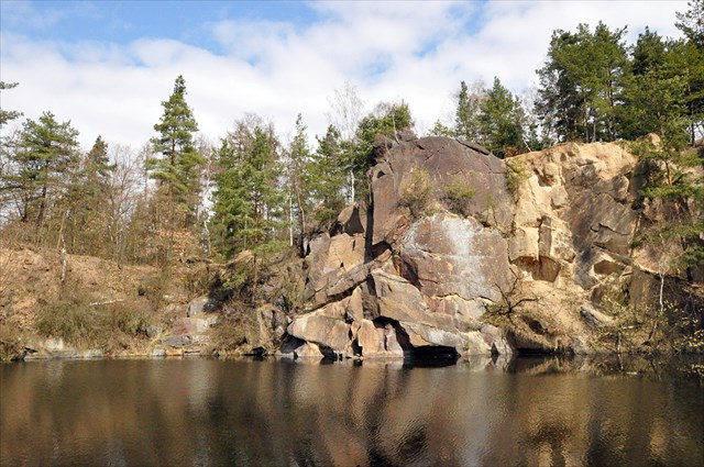
Lom Bedlno
Zatopený starý kamenolom. V lomu se natáčela filmová adaptace opery Rusalka a scény pro pohádku Nesmrtelná teta. V lese mezi Bedlnem a Chotěšovem 3 km severovýchodně od Jesenice. Cesta Jesenice k lomu není značená – ze silnice I/27 ve směru Most odbočte na silnici do Bedlna. Po 400 metrech na okraji lesa sjeďte na cestu vpravo, po 200 metrech jste na místě.
 Der Steinbruch Bedlno
Der Steinbruch Bedlno ist ein alter übergeschwemmter Steinbruch, hier wurde der Opernfilm Rusalka und die Szenen des Märchen ,,Die unsterbliche Tante‘‘ gedreht. Im Wald zwischen Bedlno und Chotesov, 3 Km nordöstlich von Jesenice. Der Weg Jesenice zum Steinbruch ist nicht beschriftet – von der Strasse I/27, Richtung Most, biegen sie auf die Strasse Richtung Bedlno ab. Nach 400 Meter am Rand des Waldes fahren Sie auf die Strasse rechts herab. Nach 200 haben Sie ihren Zielort erreicht.
The quarry Bedlno
Flooded old quarry. In the quarry a film adaptation of opera Ruselka and scenes for Czech famous fairy tail Nesmrtelná teta were made. It was located in a forest between Bedlno and Chotěšov, 3km north-westwards from Jesenice. The road from Jesenice to quarry is not marked – from road I/27 in the direction of Most you have to exit to the road to Bedlno. After 400m, on the edge of a forest go to the road on your right, after next 200m you reach the place.
Svatý Hubert

Bývalý lovecký zámek hraběte Františka Josefa Czernina z počátku 18. století postavený na neobvyklém osmibokém půdorysu. Zámek není přístupný. V blízkosti zámku kámen, na kterém podle pověsti odpočíval svatý Hubert. Zámek je z Jesenice dostupný po žluté turistické trase.
Der heilige Hubert
Das ehemalige Jagdschloss vom Graf Franz Josef Czernin wurde anfangs 18. Jahrhundert an einem ungewöhnlichen Boden gebaut. Heutzutage ist das Schloss nicht mehr geöffnet. In der Nähe liegt ein Riesenstein, an dem der heilige Hubert ruhte (nach der lokalen Legende). Das Schloss ist dank dem Wanderweg (markiert mit der gelben Farbe) erreichbar.
Svatý Hubert (St. Hubert)
Former hunting palace of count František Josef Czernin from beginning of 18.century is built on an uncommon octagonal ground plan. Unfortunately it is not open to public. Nearby the palace we can find a stone, on which (according to the legend) St.Hubert used to relax. The palace is accessible from Jesenice on a yellow turistic trail.
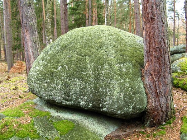
Krtské skály
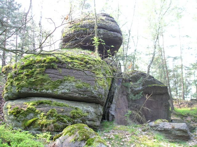 Území zaniklých lomů u obce Krty, dnes chráněné jako Přírodní památka. Krtské skály jsou z Jesenice dostupné po turistických trasách.
Krtske Gesteinen
Das Gebiet der ehemaligen Steinbrüche bei Krty ist heutzutage ein geschütztes Naturdenkmal. Krtske Gesteinensind erreichbar von Jesenice dank den Wanderwegen.
Krtské skály (Krtské rocks)
A territory of defunct quarries near by village Krty, nowdays it is protected like a natural monument. Krtské skály are accessible from Jesenice by using turistic trails.
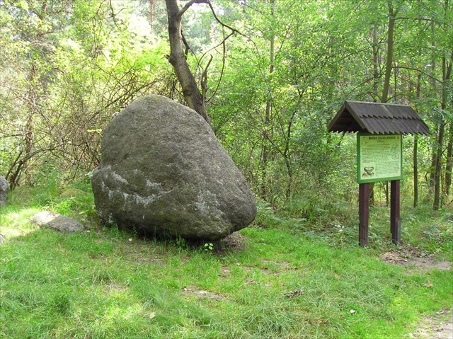
Boží kámen
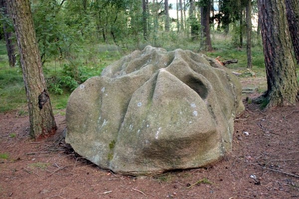
Nejznámější z tajuplných kamenů Jesenicka. Podivně tvarovaný povrch ohromného kamenného bochníku vznikl podle pověsti, když na kameni odpočíval Bůh se svými anděly. Kámen leží v lese mimo značené turistické trasy cca 0,5 km od Sosně.
Der Gottes Stein
Ist ein von der bekanntesten Stein in Jesenicko. Die komisch geformte Oberfläche des Gesteins entstand nach der Legende dank dem Gott und seinen Engel, dier sich auf diesem Stein ausruhten. Dieser Stein lieget ausserhalb den Wanderwegen, ca 500 Meter von Sosne.
God´s stone
It is the most famous mysterious stone in Jesenicko. Strangely formed surface of a huge stone bolder originated according to the legend, when the God rested on the stone with his angels.The stone is located in a wood, not marked by turistic routes, approx. 0,5km from Soseň.