|
Tuscarora Formation Facts:
|
| Also Known As: |
Tuscarora quartzite or Tuscarora sandstone |
| Formation: |
Exposed on various ridge crests and in many water gaps |
| Found in: |
Pennsylvania, Maryland, West Virginia, and Virginia |
| Primary rock types: |
quartzite (primary), sandstone (secondary) |
| Other rock types: |
shale, siltstone, conglomerate |
| Color and Texture: |
Light to medium gray or gray-green, cross-stratified and conglomerate in parts |
| Geologic Age: |
Lower Silurian (between 440 to 417 (±10) million years ago) |
The Tuscarora Formation is named for Tuscarora Mountain in Central Pennsylvania where it was first described. It is widespread in the Central Appalachians and is the primary ridge-formers of the Ridge-and-Valley Appalachians in the eastern United States. The Tuscarora Formation is over 900 feet thick in Pennsylvania and ranges from about 50 to 400 feet thick in the remainder of its range of Maryland, Virginia and West Virginia.
The primary and most distinctive constituent of the Tuscarora Formation is metamorphosed quartzite known as metaquartzite. Quartzite can be either sedimentary or metamorphic depending on its provenance. In both cases, it originates as quartz-rich sandstone, a sedimentary rock formed by the gradual eroding of upland rocks that are transported as sediment to form alluvial deposits.
The rocks that comprise the Tuscarora Formation are an indicator of the Taconic orogeny process that brought about their deposition. Its various quartzite, sand/silt stone and shale constituents indicate a beach/shore provenance that extended over a significant geologic time period; Very few fossils exist in the Tuscarora, and most of them are trace fossils.
Examples of Tuscarora Formations in the area:
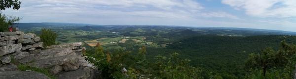
(The Pinnacle) Outcrops of hard, resistant quartzite are exposed at the apex of a tight fold in the mountains. Weathering has produced a "spire" of quartzite. (Pulpit Rock) Erosion of a sharp fold in the Tuscarora quartzite has produced a rock feature resembling a "pulpit." (North Lookout) Massive outcrop of Tuscarora sandstone, 1520 feet above sea level. (Dans Pulpit) Formed from outcrops of the Tuscarora quartzite standing in vertical columns. (Schuylkill Gap) An outstanding example of a water gap in Blue Mountain; an exceptional exposure of the quartzites and a major fault which causes this formation to repeat.
To claim this Earth Cache, email the following answers:
1. How can both types of Tuscarora Formation (quartzite at the Pinnacle, sandstone at the North Lookout) be present within four miles of each other?
2. By observing the tight fold in the mountain, what shape has the exposed Tuscarora quartzite formed at the Apex?
3. In which direction do the Tuscarora quartzite folds run at the Pinnacle? (linear or vertical)
Note - Please only log this cache if you visit the Pinnacle after its publish date. No Couch Caching. Thanks!
Recommended Hikes:
Here are some various routes you can take to the Pinnacle.
From Hamburg Reservoir: (Three possible routes) Parking GPS Coordinates: 40 35.01279388810332 N - 75 56.5171480178833 W
Furnace Creek Road:
The Hike: Follow the road up from the parking area. Cross over the small bridge over furnace Creek. When the road forks, take the fork to the left. The road will eventually take you to a metal gate. The road proceeds along the north side of the reservoir. Eventually you will come to a road that has blue blazes. Follow the road up the hill. After about 1 1/2 mile of climbing you will come to a clearing (the helipad). bear to the right after you enter the clearing, you will see a white blazed trail. This is the Pinnacle Side Trail. Follow it to the Pinnacle. This route is about an 9 1/2 mile round trip. This is my favorite way up from the reservoir, the trail is not very rocky and there aren't any gut busting uphill climbs.
Valley Rim Trail:
The Hike: Follow the road up from the parking lot. Just before the road crosses a small bridge over Furnace creek you will see a road that goes off to the right. Follow this road. After several hundred feet you will see a road the goes off to your left. Take that road, almost immediately, on your right, you will see a trail that is blazed in white. This is the beginning of the Valley Rim Trail. This trail is a slow steady climb. Near the summit you will need to scramble up some rocks to Pulpit Rock. Follow the white blazed trail from Pulpit Rock to the Pinnacle. Be forewarned, there are parts of the Valley Rim Trail where you will be climbing over large rocks. This route is about an 8 1/2 mile round trip.
The Road:
The Hike: Follow the road up from the parking lot. Cross the small bridge over Furnace Creek. When the road forks, take the fork to the left. Follow the road up to the summit. At the summit you will see the Lehigh observatory and a cell phone tower. The trail to the Pinnacle (blazed white) can be found just to the right of the cell tower. Be sure to visit Pulpit Rock before you set off for the Pinnacle. The view is awesome. The trail from the observatory to the Pinnacle gets really rocky at times. This route is about an 7 1/2 mile round trip. It seems that this route is the one most people use. The climb up the road is very steep at times.
Weiser Trail: Parking GPS Coordinates: 40 35.97712809720235 N - 76 0.05718111991882324 W
The hike: The round trip to the Pinnacle is about 10 miles. The trail is an old logging road, it is not particulary rocky and someone seems to keep the weeds trimmed. Even though the trail goes through quite a few elevation changes, there aren't any gut busting climbs.
Port Clinton Fire Tower: Parking GPS Coordinates: 40 36.25327286644321 N - 75 59.55861210823059 W
The Hike: At the fire tower there is a large parking area. The trail head is marked by a gate. The trail itself is another logging road. If you follow this trail for about 1.9 miles you will meet up with the Appalachian Trail (blazed white), follow the AT uphill and you will meet up with the Pinnacle side trail. This route is a 10.8 mile round trip.
From Eckville: Parking GPS Coordinates: 40 37.53294334713161 N - 75 57.202720642089844 W
The hike: From Eckville the round trip to the Pinnacle is about 9 1/2 miles. The trail is a logging road that is in good repair. The two mile hike to the ridge is uphill every inch of the way. At the ridge you take the Pinnacle Side trail to the Pinnacle. This route doesn't get rocky until just before you get to the Pinnacle.
Please note, if you do the hike in the spring, summer or early fall, be aware that Blue Mountain is inhabited by snakes, including rat snakes and venomous Timber Rattlesnakes and Northern Copperheads. Be careful what you touch, and where you step!
Previous Pinnacle Caches:
GCEA27 - The Pinnacle Cache (03/22/2003 - 09/25/2008)
GC1QC2F - The Pinnacle! (04/21/2009 - 06/10/2011)