Translation: 


HIGHLANDS
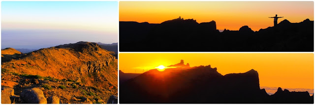
O percurso desta cache situa-se entre os 1759 e os 1400 metros de altitude.
A cache deverá ser realizada com boas condições metereológicas para que possas usufruir das abrangentes paisagens desde os mais altos picos da ilha até a cidade do Funchal.
This cache's route is located between 1759 and 1400 meters altitude.
The cache should be done with good weather conditions so you can enjoy the broad landscapes from the highest peaks of the island to the city of Funchal.
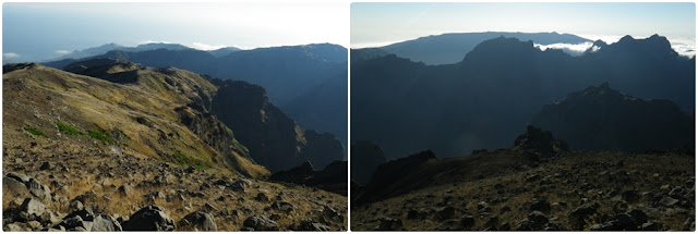
O percuso percorre a linha divisória entre os concelhos do Funchal e de Câmara de Lobos.
Irás caminhar ao longo das montanhas olhando para o Curral das Freiras, bem lá em baixo, a quase 1000m de desnível.
The route runs along the dividing line between the counties of Funchal and Câmara de Lobos.
You will walk along the mountains safely looking at the Nun's Valley, down low, with almost a 1000m gap.
O percurso poderá ser feito de diversas formas. Poderás efectuar um percurso circular, mais longo e cansativo com algumas subidas. A outra hipótese será efectuar o percurso quase sempre a descer, começando no Pico do Arieiro e terminando no Curral das Freiras. Neste caso terás de utilizar 2 carros ou outros meios de transporte.
The route may be done in several ways. You can make a round trip, longer and with some exhausting climbs. The other hypothesis is a descending trail, starting at Pico Arieiro and ending at the Nun's Valley. In this case you will have to use two cars or other means of transport.
Atenção:
- Percurso Circular: Parking - Cache - Parking: 13km / 5h (Utilizando a nova estrada: 6,3km / 3h)
- Percurso Descendente: Pico Arieiro - Cache - Curral das Freiras: 7km / 3h
- Deverás levar água e comida, roupa e calçado apropriados.
Attention:
- Roundtrip: Parking - Cache - Parking:13km / 5h (Using the new tarmac road: 6,3km / 3h)
- Descending Trail: Pico Arieiro - Cache - Curral das Freiras: 7km / 3h
- You should bring water and food and appropriate footwear and clothing.
 STAGE I
 - Pico do Cedro
(1759 metros de altitude)Neste stage irás encontrar um pequeno container com a coordenada para o stage seguinte.
At this stage you will find a small container with the coordinate for the next stage.
STAGE II - Marco /
Geodesic Landmark
A resposta a esta pergunta te dará a coordenada para a stage seguinte.
Qual destes nomes encontras aqui?
The answer to this question will give you the coordinates for the next stage.
Which of these names can you find here?
Sto António = N 32° 43.383 W 016° 56.918
São Roque = N 32° 43.481 W 016° 56.605
P.Cedro = N 32° 43.422 W 016° 56.579
STAGE III - Marco / Geodesic Landmark
A resposta a esta pergunta te dará a coordenada para a stage seguinte.
Qual destes números encontras aqui?
The answer to this question will give you the coordinates for the next stage.
Which of these numbers can you see here?
25= N 32° 43.262 W 016° 57.005
30= N 32° 43.283 W 016° 56.801
35= N 32° 43.262 W 016° 57.005
STAGE IV - Marco / Geodesic Landmark
A resposta a esta pergunta te dará a coordenada para a stage seguinte.
Quantos palmos de altura tem o marco?
The answer to this question will give you the coordinates for the next stage.
How many spans high is the geodesic landmark?
1= N 32° 43.202 W 016° 57.249
5= N 32° 43.323 W 016° 57.620
8= N 32° 43.355 W 016° 57.779
STAGE V - Marco / Geodesic Landmark
A resposta a esta pergunta te dará a coordenada para a stage final.
Qual destes números encontras aqui?
The answer to this question will give you the coordinates for the next stage.
Which of these numbers can you see here?
1= N 32° 43.138 W 016° 57.114
3= N 32° 43.144 W 016° 57.225
5= N 32° 43.265 W 016° 57.321
STAGE VI - Curral Below
Neste stage irás encontrar um pequeno container com um número. (Irás utilizá-lo para calcular as coordenadas finais)
At this stage you will find a small container with a number. (You will need it to calculate the final coordinates)
FINAL
N 32° 43.(Stage6 - 303) W 016° 57.(Stage6 - 29)
Agora que já tens a coordenada final, procura a melhor forma de chegar até a cache.
Após efectuar o log, volta à estrada e segue-a até ao ponto inicial ou desce até ao Curral das Freiras.
Now that you have the final coordinate, find the best way to get to the cache.
After making the log, go back to the road and follow it to the starting point or go down to Curral das Freiras.