O VIGILANTE / PICO DO CEDRO
Vigilante
In this island of high mountains
sometimes hell breaks loose
rain and stones roll over the valleys
As if it were a punishment from Zeus
legend has it that one day
a humble farmer looked to the hills
where he found a strange figure
that immediatly caused him chills
that strange figure had a cane
and was using a religious habit
he was wandering strangely
where no one dared to inhabit
knowing that he was being observed
his cane touches the ground as he walks
thus sending to the valley
little and harmless rocks
Seeing those rocks falling
the farmer wisely understood
so we warned the people
for their own good
When they were all safe
the whole montain collapes into the valley
they owe their lives to the stranger
who warned about this dramatic finale
História baseada na lenda de Santo Amaro (Calheta, Paúl do Mar, Sítio da Quebrada)
Story based on the legend of Saint Amaro (Calheta, Paul do Mar, Sítio da Quebrada)
 CACHE:
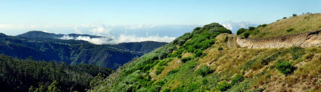
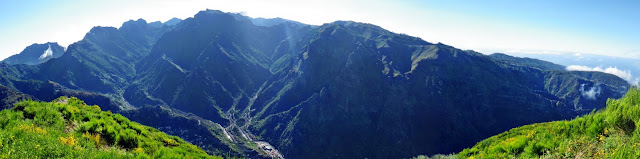
Ao chegar à cache terás a oportunidade de ser o Vigilante. Para isso tens uma boa panorâmica sobre o vale da Serra d'Àgua e sobre os principais picos da ilha. Se detectares alguma situação perigosa não te esqueças de avisar os que bem lá em baixo trabalham os campos ou saboreiam uma boa poncha.
On arriving at the cache site you will have the opportunity to be the Vigilante. For that you have a good panoramic view over the Serra d'Àgua valley and of the major peaks of the island. If you detect a dangerous situation do not forget to warn those that down at the valley are working in the fields or enjoying a good poncha.
Para chegar até à cache poderás utilizar a hipótese que mais te agradar:
To get to the cache you can use the hypothesis that suits you best:
I
Levada do Lombo do Mouro (roundtrip)
Parking:
32° 44.217'N / 17° 2.970'W
Start / End:
32° 44.176'N / 17° 2.902'W
7km (Total)
2h30
desnível / gradient: 158m
II
Levada do Lombo do Mouro - Ribeira Brava
Parking:
32° 44.217'N / 17° 2.970'W
Start:
32° 44.176'N / 17° 2.902'W (altitude: 1290m)
End: 32° 40.268'N / 17° 3.965'W (altitude: 20m)
13km (Total)
4h
desnível / gradient: 1270m
III
TT (off-road vehicles)
11km (Total)
Start / End:
32° 41.777'N / 17° 3.567'W
 FTF: Olhodegrifo FTF: Olhodegrifo |
 STF: RicardoGonçalvesrady STF: RicardoGonçalvesrady |
 TTF: ricardomariagoncas TTF: ricardomariagoncas |