A Tribute to Finnish Caves and Caving EarthCache
A Tribute to Finnish Caves and Caving
-
Difficulty:
-

-
Terrain:
-

Size:  (other)
Please note Use of geocaching.com services is subject to the terms and conditions
in our disclaimer.
Tämä EarthCache esittelee sinulle luolageologiaa, Suomen toiseksi pisintä kalkkikiviluolaa sekä suomalaista luolaharrastusta.
This EarthCache introduces you to cave geology, Finland's second longest limestone cave, and Finnish caving.
HUOM! Älä mene luolaan talvella, myöhään syksyllä tai aikaisin keväällä, sillä se voi häiritä siellä talvehtivia lepakoita!
NB: Don't go into the cave during the winter, late in the autumn, or early in the spring to avoid disturbing the hibernating bats!
Torholan luola
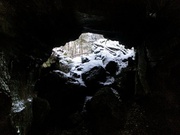 Torholan luola Lohjalla on yksi harvoista suomalaisista kalkkikiviluolista ja myös yksi suurimmista luolistamme kaiken kaikkiaan. Se on noin 30 metriä pitkä ja sisältää suurehkon eteiskammion lisäksi konttaamista ja ryömintää vaativia osia. Luola on tyypillinen liukenemisluola, eli se on syntynyt veden liuottaessa kalkkikiveä. Samalla tavalla ovat syntyneet maailmalla suuret, jopa kymmenien ja satojenkin kilometrien pituiset luolakompleksit, jotka tavallisesti sijaitsevat juuri kalkkivialueilla. Tähän mennessä tunnetuista luolastoista pisin on Mammoth Cave (yli 630 km) USA:ssa. Suomen pisin luola puolestaan on Toskaljärven kalkkikiviluola (noin 100 m) Lapissa Enontekiöllä. Luolaan ei kuitenkaan pääse, sillä sen läpi virtaa vesi.
Kuinka luolat ovat syntyneet
Kalkkikiveen syntyy luolia, sillä se liukenee helposti hieman happamaan sadeveteen. Kalkkikivi on maapallolla yleinen kivilaji, mutta Suomessa kalkkikivialueet ovat harvinaisia: kalkkikiven osuus kallioperässämme on ainoastaan 0,1 %. Suomen kallioperä on myös iältään hyvin vanhaa: se on muodostunut nykyiseen tilaansa pääosin 3000-1400 miljoonaa vuotta sitten. Se kuuluu Pohjois- ja Itä-Euroopan peruskallioalueeseen, joka on eräs Euraasian mantereen vanhimmista osista. Tämä on kalkkikiven puutteen lisäksi suurin syy siihen, miksi Suomessa on vain vähän luolia ja miksi Torholan kokoluokan luolatkin ovat harvinaisia. Kallioperän vanhuuden vuoksi eroosiolla on ollut aikaa kuluttaa maamme tasaiseksi, joten myöskään veden virtaus ei täällä pääse muodostamaan luolia kuten vaikkapa jo vuoristoisessa naapurissamme Norjassa. Noin 10 000 vuotta sitten päättynyt jääkausi tasoitti Suomen pinnanmuodot niiden nykyiseen muotoon.
Liukenemisluolat, jotka syntyvät karbonaattikiveen (kalkkikivi, dolomiitti, marmori), kipsiin tai hiekkakiveen, ovat tavallisin luolatyyppi. Yleisimmin ne ovat veden muodostamia, kuten Iso-Britannian suurin luolakompleksi, Three Counties System (102 km), ja monien pohjalla virtaa maanalainen joki. Maailmalta löytyy myös joitakin rikkihapon syövyttämiä luolia, joista tunnetuin on maailman kauneimpana luolana pidetty USA:ssa sijaitseva Lechuguilla Cave ainutlaatuisine kipsikristalleineen. Rikkihappoa syntyy, kun vetysulfidi reagoi veden kanssa. Kun luola on syntynyt maanpinnasta alaspäin valuvan veden vaikutuksesta, sitä kutsutaan epigeeniseksi luolaksi. Kun taas kyseessä on maasta kohti pintaa veden tai rikkihapon vaikutuksesta kasvanut luola, se on nimeltään hypogeeninen luola. Liukenemisluoliin, useimmin kalkkikiviluoliin, syntyy kauniita luolamuotoja kuten stalagmiitteja (maasta lähtevä tippukivi), stalaktiitteja (katosta lähtevä tippukivi) ja heliktiittejä (käppyräisiä tippukiviä, jotka ovat kasvaessaan vaihtaneet suuntaa). Tippukivien keskimääräinen kasvuvauhti on 1 mm/10 vuotta.

A. Onttoja pillejä. B. Pylväitä eli yhteen kasvaneita stalagmiitteja ja stalaktiitteja. C. Heliktiittejä.
 Liukenemisluolan synty
1. Lievästi hapan sadevesi tunkeutuu halkeamista maan sisään ja alkaa liuottaa kiveä.
2. Ajan myötä hapan vesi tuottaa kiveen reikiä. Maanalainen virta kehittyy.
3. Virta kuluttaa tien alempiin kerroksiin. Vanhemmissa käytävissä alkaa kehittyä luolamuotoja ja katon romahtamisia voi tapahtua. Luolamuodot syntyvät tippuvien vesipisaroiden sisältämistä mineraaleista.
Luola voi syntyä myös rantakallioon aaltojen aiheuttaman eroosion huuhtomana. Toisen eroosioluolatyypin muodostavat tuulen kuluttamat luolat, joita syntyy hiekkakivialueilla. Kolmas tyyppi ovat pehmeään maaperään syntyneet putket (soil pipe caves), joista vesi on kuljettanut maa-aineksen pois jättäen jälkeensä maanalaisia käytäviä.
Laavatuubeiksi tai laavatunneleiksi (lava tubes) kutsutaan luolia, jotka syntyvät tuliperäisillä alueilla: sula laava on virrannut pinnalle ja jähmettynyt, kun sen alla laava on jatkanut kulkuaan nestemäisenä muodostaen maanalaisia käytäviä. Myös jäätikölle voi syntyä luolia, kun railoihin valuu pinnalta vettä, joka sulattaa jäätä mennessään.
Suomessa luolat ovat tavallisimmin pieniä lohkareluolia. Nämä lohkareluolat ovat syntyneet, kun jääkausi on kuljettanut kiviä ja kasannut niitä päällekkäin. Myös kivien romahtaminen veden kuluttamaan laaksoon voi aikaansaada lohkareluolia. Tektoninen rakoluola puolestaan syntyy, kun kallio halkeaa kahtia esim. maanjäristyksen vaikutuksesta. Tällaisen rakoluolan päälle voi vielä kasautua kiviä ja maa-ainesta.
Torholan luola ja Pitkänperänlahden luonnonsuojelualue
Torholan luola on karstiluola, mikä tarkoittaa, että vesi on liuottanut pehmeämmät kiviainekset ja jättänyt jäljelle kovemmat. Karstimaalla tarkoitetaan tyypillistä pinnanmuotoa, joka syntyy, kun vesi liuottaa useimmiten karbonaattipitoista maata. Karstimaalle tyypillisiä ovat erikokoiset vajoamat, pystysuorat kuilut, maan alle katoavat joet sekä lähteet. Kalkkikivi on kerrostunut kivilaji, joka muodostuu kalsiumkarbonaatista. Se voi lisäksi sisältää erilaisia epäpuhtauksia kuten savea, hiekkaa, orgaanisia aineksia ja rautaoksidia, ja siksi sen väri vaihtelee valkoisesta ja harmaasta ruskeaan, mustaan ja vihreähköön.
Torholan luolasta suurin osa on syntynyt viimeisen jääkauden jälkeen, kun vesi on valunut kohti Lohjanjärveä. Tämän arvellaan tapahtuneen noin 7 000-9 000 vuotta sitten. Luola sijaitsee Pitkänperänlahden luonnonsuojelualueella Lohjan Karkalinniemellä, jonka kärjessä on Karkalin luonnonpuisto. Pääluolan lähistöltä voi löytää lisääkin pienempiä luolamaisia onkaloita. Kalkkikiven ansiosta alueen luonto on hyvin monimuotoista, ja siellä kasvaa Suomen oloissa ainutlaatuista kasvillisuutta. Kalkkikivi on kerrostunutta kalsiumkarbonaattia, ja se on erityisen hyvä kasvualusta monille vaativille kasveille. Luolaa ympäröivien lehtojen ja varjoisten kallioiden kasvillisuuteen kuuluvat mm. kynä- ja vuorijalavat, hietaorvokki, ketokäenminttu, pesäjuuri sekä useita harvinaisia sammallajeja. Uhanalainen kovakuoriainen, lohjanseppä, on Torholan luola-alueen hyönteisharvinaisuus.
Suomen luolaseura
Torholan luolasta sai kipinänsä myös 2010 perustettu Suomen luolaseura. Sen perustajajäsenet kävivät luolassa kesällä 2007 ja innostuivat seikkailusta, pimeydestä ja luolan ainutlaatuisesta tunnelmasta. Sittemmin luolaseuralaiset ovat retkeilleet isoissa ulkomaisissa luolissa, mutta kotiluola on edelleen heille rakas ja tärkeä. Ulkomailla luolailu (caving) on ymmärrettävistä syistä tunnetumpi harrastus kuin Suomessa, ja yksi Suomen luolaseuran tarkoituksista onkin edistää harrastuksen tunnettuutta Suomessa. Luolaseura on myös järjestänyt luolailun peruskursseja, joiden käytännön osuus on pidetty juuri Torholassa. Lisätietoa luolista ja luolaharrastuksesta löytyy luolaseuran nettisivulta http://caving.fi
Tehtävät
Logataksesi kätkön sinun tulee selvittää alla olevat tehtävät ja lähettää vastaukset kätkön omistajalle. Varusteet, joita tarvitset: likaantumista kestävät vaatteet, kunnollinen valo, pitkä mittanauha tai muutama metri lankaa ja mitta sekä kamera. Luolan perälle mentäessä on syytä olla varovainen, ja kypärä on suositeltava lisävaruste, joskin myös ilman sitä pärjää.
1. Mittaa Torholan luolan korkeus sen suuaukolta. Arvioi, kuinka pitkä luolan eteiskammio on suuaukolta perälle. Maailman suurimpana luolakammiona pidetään yleisesti Sarawak Chamberia Nasib Bagus -luolassa Malesiassa. Se on 100 m korkea, 400 m leveä ja 700 m pitkä, joten sinne mahtuisi pituussuunnassa esim. kahdeksan jumbo jet -konetta. Suurimmat luolat ovat siis todella valtavia. Vertaa Torholan luolan ja Sarawakin pituutta. Kuinka monta Torholan luolan eteiskammiota suunnilleen mahtuisi Sarawakiin pituussuunnassa?
2. Alhaalta eteiskammion perältä löydät reiän, joka johtaa alaspäin. Laskeudu alas. Pohjalla käytävä jatkuu kahteen suuntaan. Tavoitteenasi on ryömiä tulosuunnasta vasemmalle ja aivan luolan perälle. Sieltä löydät pienen Kellariksi kutsutun kammion, jossa mahtuu istumaan useampikin ihminen. Jos lähdet ryömimään toiseen suuntaan, käytävä mataloituu, kunnes sinne ei enää mahdu. Kellarissa mittaa kammion leveys suunnilleen sen keskikohdasta, rinnan korkeudelta
3. Mitä eri värejä Kellarin seinän kivellä on? Mistä kalkkikiven eri värit johtuvat?
4. Torholan luolassa on usein nähty erilaista elämää: mm. etanoita, perhosia, sieniä ja lepakoita. Näitkö sinä mitään elämää käydessäsi luolassa? Kerro, mitä.
5. Millä tavalla Torholan luola on muodostunut? Mainitse kaksi muuta tapaa, miten luola voi muodostua.
6. Ota kuva itsestäsi, GPS:stäsi tai molemmista luolassa. Liitä kuva loggaukseen. Tämä kohta ei ole pakollinen.
Luolan lähelle johtavalla Karkalintiellä on parkkipaikka tulosuunnasta tien oikealla puolella, ja toisella puolella tietä on viitta, joka osoittaa luolalle. Polun varrelta voit löytää myös geokätkön Torhola Cave. Huomioi, että liikut luonnonsuojelualueella. Ethän siis jätä itsestäsi muita merkkejä kuin jalanjälkiä etkä kerää mitään mukaasi. Hauskaa luolailua ja varovaisuutta matkaan!
------------------------------------------------------------------------------------------------------
Torhola Cave
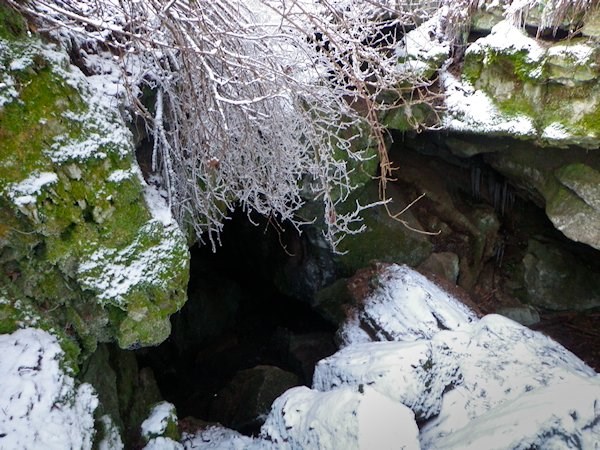 Torhola Cave in Lohja is one of the few Finnish limestone caves and also one of our largest caves. It is about 30 meters long and contains - in addition to a rather big entrance chamber - some sections with hands-and-knees crawling. The cave is a typical solutional cave which means it was formed by water dissolving the rock. World's large cave systems, some of them extending dozens, even hundreds of kilometres underground, were formed similarly, and they are typically situated in limestone areas. The longest known cave system in the world so far is Mammoth Cave (over 630 km) in the USA. Finland's longest cave is Toskaljärvi limestone cave (about 100 m) in Enontekiö Lapland. However, it's not possible to go into the cave because of the fast-flowing water.
Caves tend to form in limestone because limestone dissolves easily in weakly acid rainwater. Limestone is usually very common but in Finland limestone areas are rare: limestone accounts only 0,1 % for the Finnish bedrock. The bedrock is also very old: it has formed to its current state mainly in 3000-1400 million years ago. It belongs to the bedrock area of Northern and Eastern Europe which is one of the oldest parts of Eurasian continent. Besides the lack of limestone, this is the main reason for Finland having only a few caves, and caves sized even as big as Torhola being rare. Due to the age of the Finnish bedrock, erosion - the main reason being the last Ice Age which ended about 10 000 years ago - has had enough time to degrade the land to its current flat topography. Therefore water flow isn't sufficient to form caves as in Finland's mountaineous neighbour, Norway.
How caves are formed
The most common cave type are the solutional caves which are formed in carbonated rocks (limestone, dolomite, marble), gypsum, or sandstone. Usually they are formed by water like the UK's largest cave system, Three Counties System (102 km in length), and in many of them there is an underground river flowing in the bottom. In rare cases, caves can also be produced by sulphuric acid. Among these caves, Lechuguilla Cave in the USA is the most famous, and it's also considered to be the most beautiful of all the caves in the world with its unique, delicate gypsum crystals. Sulphuric acid is composed of hydrogen sulphide mixing with groundwater. A cave formed by the action of surface water sinking into the ground and dissolving the rock, is called an epigenic cave. A cave formed by water or sulphuric acid rising from underground towards the surface is called a hypogenic cave. These solutional caves, most commonly limestone caves, are where beautiful cave formations (speleothems) like stalagmites (growing from the ground), stalactites (growing from the roof), and helictites (contorted speleothems which have changed their direction during their growth) are formed. Average growth rate of a speleothem is 1 mm per 10 years.
A. Straws, hollow mineral tubes. B. Columns, unions of stalagmites and stalactites. C. Helictites.
Forming of a solutional cave
1. Weakly acid rainwater seeps into the ground through cracks, and begins to dissolve the rock.
2. Over time, the action of the acidic water produces holes in the rock. Underground stream develops.
3. Stream cuts to lower level. In older passages, speleothems begin to develop, and roof breakdowns can happen. Speleothems are formed by dripping water containing minerals.
Caves can also be created in seaside cliffs by wave erosion. Another erosional type of cave is a wind cave which are formed in the sandstone areas. A third type is known as a soil pipe: groundwater erodes soft sediments and washes them out leaving small caves, or pipes in the soil.
Lava tube caves are found throughout the world in volcanic areas: fluid lava has flown over the surface, and after it has cooled the lava under the crust has continued flowing as a liquid forming underground tubes. Caves can also occur in glaciers when surface streams melt the ice while channeled through crevasses.
In Finland caves are usually small boulder caves. These caves were created during the Ice Age when the ice moved rocks and piled them one on top of the other. Boulder caves can also be formed when rocks collapse or fall into a valley eroded by flowing water. A tectonic cave is formed when large slabs of solid rock move apart, for example in an earthquake. Afterwards, rocks and soil can be piled on top of this crack.
Torhola Cave and Pitkänperänlahti Nature Reserve
Torhola cave is a karst cave, which means that water has dissolved the softer rock material away, and the harder material has remained. Karst is a distinctive topography, which is formed by water dissolving usually carbonate-rich rock or soil, creating characteristic features like sinkholes, vertical shafts, springs, and rivers disappearing underground. Limestone is a sedimentary rock composed of calsium carbonate. It can also contain some impurities, such as clay, sand, organic remains, and iron oxide, and thus it exhibits different colours ranging from white and grey to brown, greenish, and black.
Torhola Cave originates from the period after the Ice Age, approximately 9000-7000 years ago, when water flowed towards Lake Lohja. The cave is situated in Pitkänperänlahti Nature Reserve, in Karkalinniemi, Lohja. Near the main cave it's possible to find other smaller cave-like holes. Because limestone is an especially good habitat for many demanding plants, nature's diversity in the area is significant, and the flora is unique in Finland. For example, European White Elm, Wych Elm, Teesdale Violet, Spring Savory, Bird's-nest Orchid and various rare moss species are found in the groves and the shadowy rocks around the cave. The endangered beetle, Pseudonostirus globicollis (Finnish name "lohjanseppä" containing the name of the city, Lohja), is a rare insect living in the area.
Finnish Caving Society
Torhola Cave was also the original source of inspiration for the foundation of Finnish Caving Society in 2010. The founding members visited the cave in the summer of 2007, and were impressed by the adventure, the darkness, and the unique atmosphere of the cave. Later on, the members of Finnish Caving Society have made trips to large caves overseas but the home cave is still dear and important to them. Understandably, caving is a more well-known hobby abroad, and one of the main goals of Finnish Caving Society is to make it more known in Finland. The Caving Society has also arranged basic caving courses whose practise part has been held in Torhola. The website of Finnish Caving Society can be found at http://caving.fi (still only in Finnish, sorry), and additional information on caves and caving in English for example at http://www.cave-exploring.com.
Tasks
To log the cache, please do the tasks below and send the answers to the cache owner. The equipment you need: clothes tolerant of mud, a proper flashlight, a long measuring tape or a couple of metres of string and a measure, a camera. Note that you need to be careful when going to the bottom of the cave, and a helmet is advisable but not absolutely required.
1. Measure the height of Torhola Cave at the entrance. Estimate the length of the first chamber from the entrance to the bottom wall. Sarawak Chamber in Nasib Bagus Cave in Malaysia is universally accepted as the largest underground chamber in the world. It is 100 m of height, 400 m of width, and 700 m of length, so eight jumbo jets easily span the chamber. The largest caves really are huge. Compare the length of Torhola Cave with Sarawak Chamber. How many Torhola Cave entrance chambers could approximately fit lengthwise into Sarawak?
2. All the way down to the end of the entrance chamber there is a hole leading down. Go down. At the bottom, the low passage continues in two directions. Your goal is to follow the passage to the left, and crawl to the bottom of the cave. There you can find a small chamber called "The Cellar" where you and a couple of others fit to sit in. If you end up crawling right the passage becomes lower and lower until you can't go any further. In The Cellar measure the width of this chamber in the middle of it at the breast height.
3. What different colours does the rock of the Cellar wall exhibit? What is the reason for different colours of limestone?
4. Different kind of lifeforms have been sighted in Torhola Cave: for example slugs, moths, fungi, and bats. Did you see any lifeforms when you visited the cave?
5. How was Torhola cave formed? Mention two other ways how caves are formed.
6. Take a photo of either you, your GPS or both in the cave. Attach the photo to your logging. This task is optional.
When approaching, there is a small parking area on the right hand side of the nearby road (Karkalintie), and on the other side of the road there is a sign pointing towards the cave ("Torholan luola"). Along the path you can also find the traditional cache Torhola Cave. Bear in mind that you are in a nature reserve so leave nothing but footprints, and don't pick anything with you. Have a good caving, and take care!
------------------------------------------------------------------------------------------------------
Lähteet / References:
Bewley, Djuna & Bunnell, Dave 1995: Virtual Cave.
Burger, Paul 2012: Cave Types. Cave Exploring.
Canadian Cave and Karst Information Server 1995: What is Karst?
Metsähallitus 2017: Torholan luolakallio ja Pitkänperänlahden luonnonsuojelualue. Luontoon.fi-verkkopalvelu.
Mulu Caves Project 2009: The World’s Largest Underground Chamber.
Taylor, Michael Ray (NOVA) 2012: Journey Into Lechuguilla Cave
Turunen, Mikko: Suomen kallioperä. Geologia.fi-geoportaali. Suomen Kansallinen Geologian Komitea (SKGK).
Wainwright, Martin 2011: Potholers break through the final Three Counties link.
Wikipedia: Limestone.
Kuvat:
©Mustavaris
Additional Hints
(No hints available.)