(©#2)


 «Rocca Clarì - La Via Ferrata» «Rocca Clarì - La Via Ferrata»
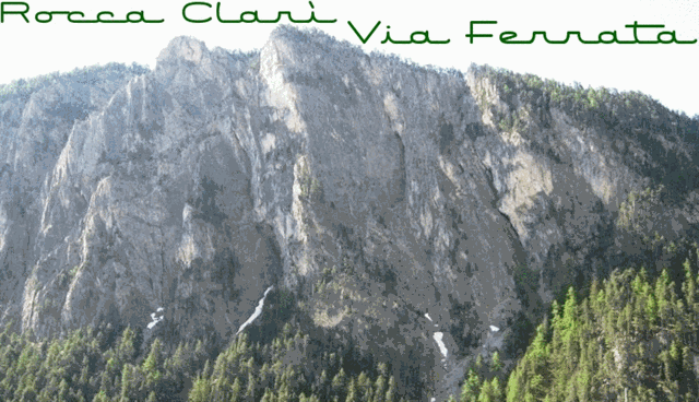
La Rocca Clarì (2051 m), pur non essendo una delle montagne conosciute ed importanti della valle, è sicuramente una di quelle più sovente ammirate, in quanto il suo versante NO precipita imponente e selvaggio nella valletta della Piccola Dora (Gorge di San Gervasio), pertanto ben visibile percorrendo la Strada Statale del Monginevro, tra Cesana T.se e Claviere.
La Via Ferrata è stata dedicata a Mario Perona e Aldo Saglia, rispettivamente guida alpina e pilota di elicottero deceduti nel 2003 in un tragico incidente insieme ad altre 4 persone.
Essa e classificata con difficoltà D+ e il suo percorso supera un dislivello di oltre 550 metri con una durata di circa 3 ore. E' considerata una delle più severe, se non la più severa, della Valle di Susa, per lunghezza, sviluppo, esposizione ed impegno e non è adatta a chi soffre l'esposizione al vuoto.
Per una descrizione dettagliata e una cartina del percorso visita questo link al sito: Altox.it.
Accesso: Dallo spiazzo (WP Parking1) in prossimità del Ponte sulla Piccola Dora seguire il sentiero che si inoltra nella gorge di San Gervasio per una decina di minuti fino al WP Trailhead.
Puoi anche parcheggiare a Claviere al WP Parking2. In questo caso l'accesso è più lontano dato che devi percorrere l'intera gorgia sulle passerelle fino all'attacco della VF. Al ritorno in compenso risparmi strada. Buon divertimento!
 «Rocca Clarì - The Via Ferrata / fixed rope route» «Rocca Clarì - The Via Ferrata / fixed rope route»
The Rocca Clari (2051 m a.s.l.), although is not one of the well known and important mountains of the valley, is certainly one of those most often admired, as his side Nort-Western rockface falls down steep and impressively into the Piccola Dora's valley (Gorge of San Gervasio) and is therefore clearly visible while travelling on the Monginevro highway between Cesana Torinese and Claviere.
The Via Ferrata, has been dedicated to Mario Perona and Aldo Saglia, respectively mountain guide and helicopter pilot who died in a tragic accident in 2003 together with 4 other people.
It is classified with a difficulty grade D+ and its climbs over 550 meters with a duration of about 3 hours. Ity considered one of the severe, if not the most difficult of the Susa Valley, for length, development, exposure and commitment . Easily passable by expert mountain climbers, but very complex and challenging for those who haven't enough experience in this kind of routes, or those suffering from exposure.
For a detailed description (in italian) and route map visit this website Altox.it.
Access: From the clearing (WP Parking1) in the vicinity of the bridge over the Little Dora follow the path that leads into the gorge of San Gervasio for about ten minutes until the WP Trailhead.
You can also park in Claviere at WP Parking2. It's a bit more far away and you'll have to pass through the gorge on the walkways up to the starting point of the Via ferrata VF. In compensation on the way back you'll save some time. Have fun!
 «Rocca Clarì - Die Via Ferrata / Klettersteig» «Rocca Clarì - Die Via Ferrata / Klettersteig»
Die Rocca Clari (2051 m ü.d.M.), gehört gewiss nicht zu den bekannten und "wichtigten" Berge des Tales, aber sie ist sicherlich einer der am häufigsten bewunderten, da die Nord-West Felswand steil und imposant in das Tal der Piccola Dora (Schlucht von San Gervasio) stürzt und daher deutlich sichtbar ist wenn man auf der Bundestrasse von Monginevro zwischen Cesana Torinese und Claviere unterwegs ist.
Die Via Ferrata, ist Mario Perona und Aldo Saglia respektive Bergführer bzw. Hubschrauberpilot, die bei einem tragischen Unfall im Jahr 2003 zusammen mit 4 weiteren Menschen starben, gewidmet.
Sie ist mit einem Schwierigkeitsgrad D+ klassifiziert und überwindet eine Höhendifferenz von mehr als 550 Metern mit einer Dauer von ca. 3 Stunden. Sie wird als einer der anspruchvolleren Klettersteige, wenn nicht der schwerste des Susa-Tals, was Länge, Anstrengung und Exponierung betrifft, angesehen. Leicht begehbar für erfahrerene Bergsteiger, aber sehr komplex und schwierig für diejenigen, die nicht genug Erfahrung mit solch einer Art von Routen haben oder unter Höhenangst leiden. Für eine detaillierte Beschreibung (in italienisch) und eine Karte dieser Route folge diesem Link: Altox.it.
Zustieg: Vom Parkplatz (WP Parking1) in der Nähe der Brücke über die Piccola Dora, dem Weg, der in die Schlucht von San Gervasio führt, etwa zehn Minuten folgen, bis zum WP Trailhead.
Ihr könnt auch in Claviere am WP Parking2 parken. In diesem Fall wird der Zustieg etwas länger da Ihr die ie gesamte Schlucht bis zu dem Trailhead der Via ferrata durchlaufen müsst. Zum Ausgleich ist dann aber der Rückweg kürzer. Viel Spass!
 Tenere sempre in considerazione le previsioni del tempo. Always keep an eye on the weather forecast. Tenere sempre in considerazione le previsioni del tempo. Always keep an eye on the weather forecast.


|