If you love scenic, winding roads deep in the woods, then Skate Creek Road (aka Forest Road 52) will make you giddy. It twists and turns for 25 miles from Ashford to Packwood, following the meanderings of its namesake stream, with numerous pullouts to enjoy the breath-taking beauty of the rushing waters and surrounding forest.
The upper and lower sections, near Ashford and Packwood, are flatter and interspersed with private lands. But the middle section is in Gifford Pinchot National Forest and descends right next to Skate Creek - a nonstop feast of visual treats, with plenty of primitive campsites for those wanting to stay a spell. And watch out for motorcyclists, as it's a popular road trip for bikers.
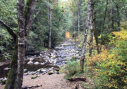
Skate Creek's splendors vary with the seasons. In spring, you may see waterfalls cascading from surrounding cliffs and hillsides. In summer, the verdant forest takes hold, drawing campers galore. Memorable fall foliage has earned Skate Creek Road the honor of “Best Sunday Drive in Lewis County for Fall Color.” And when winter snows take hold, most of the road closes to vehicular traffic (appr. Dec 1 - March 31) and it becomes Skate Creek Sno-Park, a popular destination for the snowmobiling crowd.

Skate Creek Road is not well-maintained, with uneven surfaces and potholes in sections, so be careful. As noted, the road may be closed in winter (it's not plowed), so check before you go during the snowy months (the cache is inside the closure area).
The cache: The cache is at a large pullout next to a lovely section of the stream. Signal accuracy can be challenging due to surrounding hills, so look for the large, lone alder near the south end of the pullout. The rocks at its base hide the treasure. You don't need to leave the pullout to find this cache, so if you are down near the creek, you're in the wrong spot.
2016 was the 100th anniversary of the National Park Service, and to celebrate, Visit Rainier and WSGA hosted the Visit Rainier Centennial GeoTour - 100 caches placed in and around Mount Rainier National Park. The geocaches highlighted the rich history, scenic wonders, quaint communities, and hidden gems of the Rainier region. Participants received geocoin and pathtag prizes for finding all the caches.

