BORKE'S LUCK POTHOLES
Note access to GZ is not required, all info can be found around the main potholes site
Located in the heart of the Blyde River, the Borke's Luck Potholes are one of the most important geological phenomena in the area. We went to the area armed with only a Geomate Jr and was sure there had to be an earthcache. Suprisingly there wasn't and that's why we are placing one .
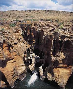
The Bourke's Luck Potholes are a prime example of a Giant's Kettle. A Giant's Kettle is also known as a Giant's Cauldron or Pothole. They are "holes" that appear to have been drilled into the rock. These generally tend to be smooth, unlike plunge pools, formed from a waterfall or something similar.
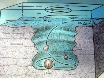
Potholes form where a rock (or many rocks) is spun around in the same spot by circular whirlpool of water, often aided by sediments and minerals within the water. In this case you will have to observe the water movements and comment on how you think the sediments were formed. The constant abrasion begins to wear away the rock into a hole. The rock being spun in the hole is called a grinder and as one grinder wears away another rolls in to fill its place. The grinder grinds away the rock and smoothens it.

The Whirlpool action that forms a pothole and its smoothness
The grinder "grinds" away the rock
 Location Specific Geology
These potholes were formed after millions of years of geological activity. Chemical Weathering (When chemicals such as acids wear away the rock) and Physical Weathering (When natural elements such as pressure and diurnal temperatures wear away and break the rock). In this circumstance, most of the erosion was chemical as the water wearing away the rocks has a high salt content. The high pressure of the water is caused by the meeting of the Blyde and Treue rivers which creates a "whirlpool" effect. The Blyde and Treue rivers are wide and powerful, creating much force required in the formation of the potholes. The rock face is characturised by the sedimentary stone, deposited millions of years ago. Erosion in the area in the forms described above has exposed quartzite layers and soft shale in between.
About 35km north of Graskop, lies the village of Bourke's Luck. This area set adjacent to the Truer River is part of the Blyderivierspoot Nature Reserve, and the potholes mark the start of the Blyde River Canyon. The potholes were formed by swirling water erosion, of the Black Reef quartzite that makes the river's bedrock. First, river-bourne pebbles and boulders carve out small depressions, which soon trap river debris. The hollows grow over time and deepedn to cylindrical potholes up to several meters deep. The reason this is not a common site and, why it is found here is because of the delicate equilibrium that needs to be maintained between river curren, the shaping pebbles and the bedrock itself, in order to keep the rock clasts in place for long enough to effect their entrapment. The name comes from the gold prospecor Tom Bourke, who is rumored to have found considerable amounts of gold in the potholes. If you are interested attempt to find out why he would've?
Above the main rock wall are areas that are not cordoned off. You can walk on these. Here, smaller potholes and their grinders can be seen, helping you with some of the questions below. From here, requirement 3 can be answered.
Requirements - please feel free to log after messaging me. I will contact you if there are any issues
1. Comment on the weathering of the main rock wall. Describe its texture and appearance. Using the description how was this (the texture) created. (EMAIL ME)
2.What type of stone is the grinder made out of? Where are these types of rocks created?
3. Have a look at a small and a large pothole. Explain the difference in dimensions.
4. Post a photo of you/your GPS at GZ (OPTIONAL)
5. BONUS MARKS: Why would have Bourke found gold? (OPTIONAL)
RESOURCES
Personal Knowlege/ Visits to the area
Wikipedia
Sabie Tourism Website.
Thanks to GeoawareGBL for the help with the requirements etc.