To claim this cache, you need to complete the following tasks.
Please forward your answers by email. geocache@wallace.net.nz
Do Not include answers in your log.
1. Take a measurement with a tape measure in centimetres the length and width (breadth) of one "pan" formation.
2. go to the sign along the walkway down to the pathway and in your email explain why a loaf is not a pan.
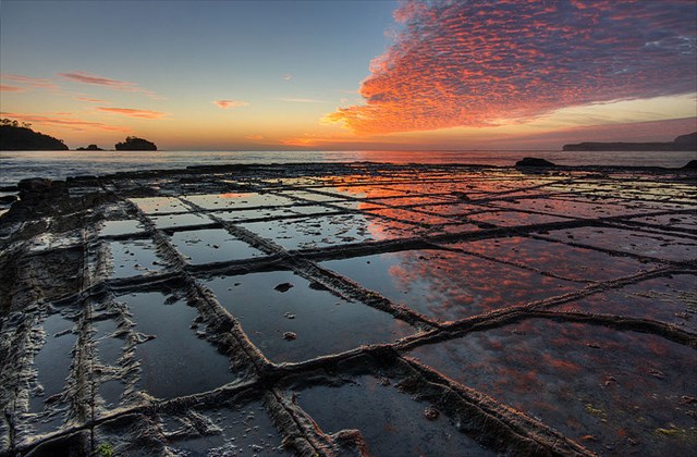
A tessellated pavement is a rare erosional feature formed in flat-lying sedimentary rock formations that occurs on some ocean shores. It is so named because the rock has fractured into regular rectangular blocks that appear like tiles, or tessellations. The cracks (or joints) were formed when the rock fractured through the action of stress on the Earth’s crust and were subsequently modified by sand and wave action.
The pan formation is a series of concave depressions in the rock that typically forms beyond the edge of the seashore. This part of the pavement dries out more at low tide than the portion abutting the seashore, allowing salt crystals to develop further; the surface therefore erodes more quickly than the joints, resulting in increasing concavity.
The loaf formations occur on the parts of the pavement closer to the seashore, which are immersed in water for longer periods of time. These parts of the pavement do not dry out so much, reducing the level of salt crystallisation. Water, carrying abrasive sand, is typically channelled through the joints, causing them to erode faster than the rest of the pavement, leaving loaf-like structures protruding.
TO LOG THIS EARTHCACHE
visit this location, and email me via GC profile or direct - earthcache@wallace.net.nz
1. Take a measurement with a tape measure in centimetres the length and width (breadth) of one "pan" formation.
2. go to the sign along the walkway down to the pathway and in your email explain why a loaf is not a pan.
OPTIONAL: As always with earthcaches, photographs of you at the location are appreciated.