This earthcache will bring you to the area located in a remote and wild section of Great Basin National Park. Here you can see a beautiful artwork of nature.
GREAT BASIN
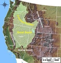
It is a region of interior drainage bounded prominently on the west by the Sierra Nevada and the Cascade Range and on the east by the middle Rocky Mountains and the Colorado Plateau. It encompasses most of the state of Nevada and part of Utah bounded by the Wasatch Mountains and the high plateaus
The majority of the rocks in Great Basin National Park formed during the Cambrian, a time when western North America was located near the equator as part of a continent called Laurentia. Thick layers of limestone, shale, and sandstone accumulated along a passive margin, where warm shallow seas lapped at the edge of the continent, similar to regions like islands of the modern Caribbean.
These rock units have survived numerous episodes of mountain building (orogenies). One of them, the Sevier Orogeny, pushed thick layers of rock on top of one another that doubled the thickness of the earth’s crust. This caused the metamorphism that turned the sandstone into quartzite, shale into slate, and limestone into marble. The Cretaceous is the same time when magma intruded or pushed its way into the overlying rock layers. This magma cooled, forming the bodies of granite found throughout the park.
Much of the Great Basin is part of the larger Basin and Range Province. Here, the Earth's crust has undergone extreme stretching as the Pacific plate has pulled away from the continental plate (type of divergent plate boundaries). The modern basin and range topography is relatively new, forming in the last 30 million years, during which time the crust of the Great Basin has been subjected to extensive stretching and thinning. The result of this stretching caused the crust to break up into blocks. Some of these blocks slid down past one another along faults forming the valleys, and those blocks that remained intact formed the mountains of today.
Sierra Nevada and Cascade Mountains create a rain shadow over much of the Great Basin, preventing many Pacific storms from reaching the region. The uplift of crossing air masses, caused by these mountains, provides cooling and precipitates much of the moisture out of the Basin. The result is dry and cold desert. There is no water surplus or stream originating in such a climate. Instead, water collects in shallow salt lakes, marshes, and mud flats, where it evaporates in dry desert air.
SNAKE RANGE
Snake Range is a mountain range with a maximum elevation of 13,063 feet (3,982 m) at the summit of Wheeler Peak. Majority of this range is covered by Great Basin national park. It is composed of quartzite, shale, and limestone intruded by small bodies of granite. Quartzite is extremely hard rock resistant to erosive forces forming the high peaks and cliffs in the park. Limestone is easily eroded by water into exotic geologic features such as Lexington Arch and Lehman Caves.
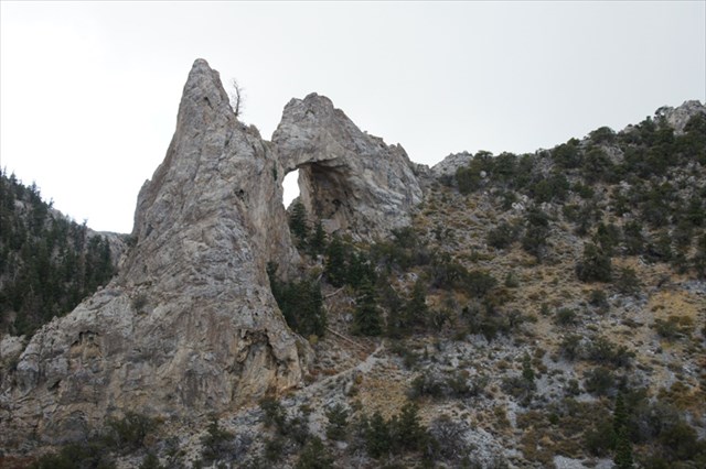
LEXINGTON ARCH
Rising high above the floor of Lexington Canyon is an imposing arch that was created by the forces of weather working slowly over the span of centuries.
While most of natural arches and bridges are formed of sandstone, Lexington Arch, in contrast, is formed of limestone. Limestone bedrock is normally associated with underground formations, such as the numerous caves and caverns that are found in Great Basin National Park. Above ground arches carved from limestone are relatively rare, and Lexington Arch is one of the largest limestone arches in the western United States.
The fact that Lexington Arch is made of limestone leads to speculation that it was once a passage in a cave system. It is even possible that Lexington Arch is not an arch at all, but rather it is a natural bridge. It is possible that long ago, when Lexington Canyon was not as deep, the waters of Lexington Creek flowed through a cave in the wall of the canyon and in doing so enlarged the tunnel that became Lexington Arch. Regardless the way of formation, Lexington Arch is still being eroded by the forces of weather today.
sources:
- John Van Hoesen, Geology of Great Basin, National Park Service
- http://www.nps.gov/grba/index.htm
- http://en.wikipedia.org/wiki/Great_Basin
HOW TO GET THERE?
From the Great Basin Visitor Center in Baker, drive south on NV Hwy 487 10.7 miles (17.2 km). On this stretch you will cross the state line into Utah, at which point NV Hwy 487 becomes Utah 21. Pass through the town of Garrison, and then pass Pruess Lake on your right. Look for the first dirt road on the right just south of Pruess Lake. Turn right onto the dirt road with a sign for Lexington Arch.
Proceed west 12.0 miles (19.3 km). The road will branch in a few places. At each fork look for the sign indicating the correct direction to Lexington Arch. The road ends in a small parking area with a sign indicating the trail to Lexington Arch. Park here.
The hike to the base of the Arch is 1.7 miles (2.7 km). The trail rises 820 feet (250 m). The first mile of the trail climbs up a steady grade and then levels off before crossing into the park. The last quarter mile climbs several short switchbacks to the arch.
High clearance vehicles are recommended. Four-wheel drive is usually not required, it is recommended after rain in this area.
QUESTIONS TO ANSWER (email me your answers, do NOT post them in your log):
- Estimate the height of the arch (just the inner part).
- You can see two peaks on the complete arch formation from the coordinates. From the posted coordinates, is the higher one on the left side or the right side ? You will have to go closer to the arch to be sure!!!
- What is the difference between arch and bridge?
- In your opinion, is this geological feature really natural arch or rather bridge? Give some explanation why you think so.
- Optional task is to upload any picture from earthcache location
"FOUND IT" logs will be DELETED WITHOUT FURTHER NOTICE if the answers are not received within seven days of the post date. You can log your visit immediately after you send your answers. I will contact you only if there is some problem. Previous visits do not count.
ENJOY YOUR HIKE TO THIS BEAUTIFUL ARCH!!!

free counters