As this area is designated as SSSI, please complete the cache requirements from the bridge.
This was part of the 64 caches Queen Diamonds Jubilee Walk (1952 - 2012) series plus three extra caches (The Queens Carriages, Buckingham Place and Balmoral) placed to commemorate the Queens Diamond Jubilee.
The Arun
Its source is a series of small streams (known locally as ghylls or gills) in the St Leonard's Forest area, to the east of Horsham. It flows through Horsham to the west and at Nowhurst is joined by North River (aka River Ockle). It winds it way through the west Sussex country side, past Arundel castle and into the English Channel at Littlehampton.
History
The mouth of the river has not always been at Littlehampton. Until the later fifteenth century it joined the River Adur at Lancing some ten miles to the east before entering the sea. This estuary became blocked with shingle by the eastward drift of the tides, pushing the Adur towards Shoreham-by-Sea, while the Arun broke out at Worthing, Goring and Ferring at various times, until it formed its present estuary at Littlehampton between 1500 and 1530.
How rivers sculpt our landscape
Erosion and Deposition
Valley or stream erosion occurs with continued water flow along a linear feature. The erosion is both downward, deepening the valley, and headward, extending the valley into the hillside. In the earliest stage of stream erosion, the erosive activity is dominantly vertical, the valleys have a typical V cross-section and the stream gradient is relatively steep. When some base level is reached, the erosive activity switches to lateral erosion, which widens the valley floor and creates a narrow floodplain. The stream gradient becomes nearly flat, and lateral deposition of sediments becomes important as the stream meanders across the valley floor. In all stages of stream erosion, by far the most erosion occurs during times of flood, when more and faster-moving water is available to carry a larger sediment load. In such processes, it is not the water alone that erodes: suspended abrasive particles, pebbles and boulders can also act erosively as they traverse a surface, in a process known as traction.
Bank erosion is the wearing away of the banks of a stream or river. This is distinguished from changes on the bed of the watercourse, which is referred to as scour. Erosion and changes in the form of river banks may be measured by inserting metal rods into the bank and marking the position of the bank surface along the rods at different times.
Desposition occurs when a river drops its load. This usually occurs when the speed or volume of the river decreases. The load, which it carries, is deposited. The heavier material is deposited first and the finer material carried further. Rivers reduce their speed when they enter flat land, meander, enters a lake or the sea or reach an arid area.
Solution Soluble minerals dissolve in the river water and are carried away as solution. Minerals that dissolve easily include calcium and sodium. This type of transportation occurs at almost anytime when there is water. Suspension Fine materials can be suspended in the water and therefore are carried away in such a method. These particles are to light to sink to the bottom of the fast moving river. Suspension load forms the largest part of the river load. Materials that can be suspended include silt, mud and clay.
To claim this cache, you will need to answer the following questions;
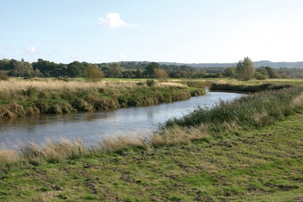
At the published coords, look west from the bridge:
1. Describe the action and forces the river is having upon the bank in front/right of you and compare it to the opposite bank.
2. Please explain which side of the river is flowing faster due to the current landscape.
3. Please name the materials process that occurs on the left hand side of the river here and explain why this happens.
Now turn and look east from the bridge:
4. Due to the sudden turn of the Arun a hundred or so metres upstream, please describe the visual differences in the river banks here and explain the effects that the river has had on both banks.
5. Take a minimum of 5 elevation measurements with your GPS at the published coordinates and provide an averaged elevation reading, (metres).
6. Optional Bonus: A photo of yourself at the published coordinates
Please look at the earthcache from a purely earth science basis. Unfortunately some seasonal vegetation may hide some of the features but with some additional research online the answers are obtainable.
Note: Please remember to number your answers so that we can review your responses quickly and easily to allow us to respond without too much delay.
Please e-mail me your answers through my profile.
WARNINGS:
- Parts of the route takes you along the river Arun so please keep a close eye on any children and dogs that you have with you.
- There could be stands of Giant Hogweed along sections of the river - this is an impressive plant (looks like 12 foot cow parsley) but it has caustic sap and will cause blistering of exposed skin, especially in strong sunlight, so although no caches are hidden close to it, you should still be careful, especially with children.
- You will have to cross the A29 a few times so please ensure you look out for any children and dogs with you.
- You also have to cross a railway line at one point so please ensure you look out for any children and dogs with you.
- There are a couple of sections of road that need to be walked along. Generally these are quite country lanes with good paths or verges, but once again please watch out for your children and dogs.
- Parts of this route can get very muddy when wet so please ensure that you wear appropriate footwear.