If you are interested in earth sciences we know a very exciting place for you.
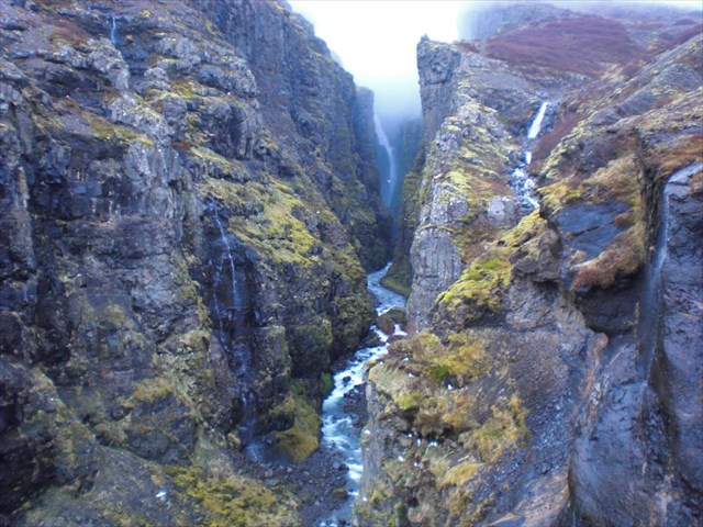
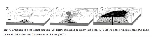
The valley Botnsdalur is a continuation of the fjord Hvalfjörður in eastern direction. Previously it was larger than today, but something changed it fundamentally during the last ice age: the volcano Hvalfell erupted. First under the glacier, later it grew bigger and rose into the air. The volcano Hvalfell is a Tuya. Tuyas in Iceland are sometimes called table mountains because of their flat tops. A tuya is a type of distinctive, flat-topped, steep-sided volcano formed when lava erupts through a thick glacier or ice sheet. They are somewhat rare worldwide, being confined to regions which were covered by glaciers and had active volcanism during the same period. Tuyas are a type of subglacial volcano that consists of nearly horizontal beds of basaltic lava capping outward-dipping beds of fragmental volcanic rocks, and they often rise in isolation above a surrounding plateau. Tuyas are found throughout Iceland.
http://en.wikipedia.org/wiki/Tuya
The volcano Hvalfell blocked the water from above to drain into the sea, so the lake Hvalvatn was formed and the river Botnsá had to look for a new way. At one point the river met a high stage: the waterfall Glymur emerged. Since then the water did a hard working piece: it has carved a valley into the slopes of the table volcano Hvalfell.
While standing at the lookout point, you can recognize the layer structure of the volcano clearly. The water has made a cut into it and therefore we are allowed to have a look at it. The various red and black colored layers have a different structure and hardness.
Go there and fulfill the following tasks:
Look at the opposite side of the canyon.
Estimate (in meters):
a) The thickness of the widest and
b) The thinnest layer of the countless layers.
c) Can you explain how the different layer thicknesses have been created?
From the parking is a marked hiking trail leading through a gate. After a few hundred meters, follow the way to the right. This way leads to the southern side of the river. It's a narrow and steep path, passing through a cave and going down to the river. There you will find a "bridge", where you have to cross the river. Follow the path, which is now steep, muddy and rocky. Sometimes it leads close to the cliff edge, so be careful.
To find out the correct answer to the geological question, you don’t have to go further than up to the viewing point at N 64 ° 23.105 W 021 ° 15.697. From there you have a great view to the Glymur waterfall and the layer structure of the volcano.
To log this cache, send to us via profile e-mail the answers to the questions a) – c) above
Feel free to log your find, we will contact you if your answers are not correct.
The waterfall Glymur, with a cascade of 196 m, is on of the highest waterfalls of Iceland.
Íslenska:
Ef þú hefur áhuga á jarðvísindum, Mun þér líklega finnast þetta vera áhugaverður staður. Botnsdalur er innst í hvalfyrði. En áður fyrr var dalurinn mun stærri en hann er í dag: Á ísöld gaus í Hvalfelli, sem þá var undir jökli. Hvalfell er Móbergsstapi en það er sértök gerð eldfjalla sem myndast einmitt þegar eldgos verða undir jökli: Þegar gosefni hlaðast upp undir þykkri íshellu myndast stapi með bröttum hlíðum og flötum toppi. Móbergsstapar eru sjaldgæfir í heiminum, En þá er aðallega að finna þar sem mikið hefur verið um eldgos undir jöklum. Þess vegna er nokkuð um þá hér á íslandi. Fjallið er augljóslega mikil hindrun fyrir það vatn sem rennur til sjávar á svæðinu, Það hefur myndast stöðuvatn aftan við fjallið (Hvalvatn) og Botnsá hefur þurft að finna sér nýjan farveg meðfram fjallinu þar sem fossinn Glym er að finna. Botnsá hefur grafið djúpa gjá í hlíðum Hvalfells og þessvegna fáum við einstakt tækifæri að skoða hvernig móbergsstapi verður til. Þar sjáum við rauðleit og dökk móbergslög sem hafa mismunandi áferð.
Farðu þangað og leystu eftirfarandi verkefni: Skoðaðu gilið hinummegin við fossinn vel og áætlaðu
(í metrum):
a) Hversu breitt er þykkasta lagið?
b) Hversu breitt er þynnsta lagið?
c) Getur þú útskýrt hvernig þessi lög hafa orðið til?
Leiðarlýsing: Frá bílastæðinu er merktur stígur sem liggur í gegnum hlið. Eftir nokkur hundruð metra fylgir þú slóðanum til hægri. en hann leiðir þig að suðurbakka Botnsár. Þetta er nokkuð brött leið. Til að finna svar við spurningunum þarftu ekki að fara lengra en að útsýnisstaðnum (N 64 ° 23.105 W 021 ° 15.697) Þaðan er gott útsýni að Glym og auðvellt er að skoða hvernig fjallið er lagskipt. Til að skrá þetta earthcache, Sendu okkur email í gegnum geocaching síðuna. og sendu okkur svörin þín. Endilega skráðu heimsóknina, Við höfum samband ef svarið þitt er rangt.
If you are interested in Iceland sagas, here is one concerning the name of Glymur:
According to local tales, there once was a local farmer’s son who had a fling with an elf lady. However, he betrayed her. This enraged her so much that she turned him into an angry red whale called “Rauðhöfði”. Rauðhöfði means red head, as he had been red headed. He was quite unhappy with this new role, so in his rage he attacked fishing boats on Hvalfjörður. Hvalfjörður means Whale Fjord, named after this whale. One day Rauðhöfði drowned the son of the priest at Saurbær. The old blind priest asked his young daughter to lead him down to the sea. There he tapped his cane in the water until the whale swam toward shore. He then walked along the beach tapping his cane to the end of the fjord. There he continued up the river and up into the Glymsgil canyon on the picture above. The whale continued swimming up the narrow canyon with a thunderous roar, thus giving the waterfall its name Glymur. The whale then fought its way up the 196 meter high waterfall and into the lake, Hvalvatn (Whale Lake) just above the waterfall. There it exploded from exhaustion.
There are also other explanations for the name:
The thunderous noise is actually the reason why it is called Glymur.
Glymur is a word for a “thundering echo”.
Take a lot of pictures. We're looking forward your logs!
Team 3Koenige