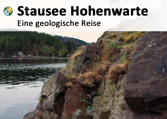
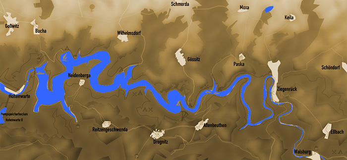
Der Hohenwarte-Stausee liegt im Süden Thüringens und wird auch liebevoll als "Thüringer Meer" bezeichnet. Er ist Teil der fast achtzig Kilometer langen, fünf mal hintereinander gestauten Saalekaskade, dem größten zusammenhängenden Stauseegebiet Deutschlands. In unzähligen Windungen durchschlängelt unser "Thüringer Meer" das Saaletal zwischen steilen Hängen, inmitten einer faszinierenden Waldlandschaft. Dazu gehören noch saaleabwärts das Ausgleichsbecken Eichicht sowie saaleaufwärts das Ausgleichsbecken Burgk, die Talsperre Walsburg und der Bleiloch-Stausee.
Mit dem Speicherraum von 182 Millionen Kubikmeter Wasser ist diese Talsperre die viertgrößte in Deutschland. Das Wasser wird zu einer Gewässeroberfläche von 7,3 Quadratkilometern (jahreszeitlich leicht schwankend, abhängig vom Wasserstand) angestaut. Zweck des Stausees ist der Hochwasserschutz, die Betriebswasserversorgung und die Elektrizitätserzeugung und -speicherung.
Der Stausee wird auf seiner gesamten Länge von einem metamorphen Gestein und tektonisch deformiertem Sedimentgestein begrenzt, deren gemeinsames Merkmal die hohe Spaltbarkeit entlang parallel zueinanderliegender Flächen ist. Bei diesem Gestein hat sich unter hohem Druck und Temperatur aus Tonmineralen neue Schichtsilikate (Muskovit, Biotit und Chlorit) gebildet, die allesamt parallel zueinander ausgerichtet sind. Dadurch ergibt sich die gute Spaltbarkeit des Gesteins. Die Bildung des typischen Aufbaus dieses Gesteins und der beschriebenen Gesteinsschichten nennt man Kristalloblastese. Bestimmte Minerale der Granat- und Amphibolgruppe lassen Rückschlüsse auf die Druck- und Temperatur-Bedingungen der Metamorphose zu. Die senkrecht zur Druckrichtung der Metamorphose ausgerichtete Gesteinsebene hat nichts mit der ursprünglichen sedimentären Schichtung zu tun; diese Ebenen können in jedem beliebigen Winkel zueinanderstehen.
An der Stelle des Earthcaches kann man dieses Gestein näher betrachten.
Achtung! Für den Besuch des Earthcaches ist zwingend ein Boot (Ruderboot, Kajak, Motorboot, etc.) erforderlich, damit man die Gesteinsschichten östlich der Koordinaten sehen und den Stein vermessen kann. Daher ergibt sich auch die Terrainwertung T5!
|
Quellen:
http://www.stausee-hohenwarte.com/ |

|
Um diesen Cache loggen zu dürfen müsst ihr folgende Fragen beantworten:
- 1. Um was für Gestein handelt es sich? Begründe deine Behauptung!
- 2. Welche Höhe zeigt euer GPS auf dem höchsten Punkt der Landzunge an?
- 3. Beschreibe mit eigenen Worten,was im Laufe der Zeit mit dieser Landzunge geschehen wird und warum?
- 4. Beschreibe mit eigenen Worten die Felsformation östlich von dir inklusive deren
Besonderheiten/Merkmale/Farbe und Aussehen.
• Sende mir bitte die Antworten auf meine Fragen. Du kannst sofort loggen.
Ich melde mich, wenn etwas nicht stimmt.
• Optional, aber gern gesehen: Macht ein Bild von euch wenn ihr beim Earthcache seid
und hängt dieses nach der Logfreigabe an euren Online-Log an.
|
|
The retaining lake in the south of Thuringia and is also affectionately known as the "Thuringian Sea". The lake is part of nearly eighty-kilometer, five times in succession stowed cascade hall, the biggest lake area in Germany. In countless turns winding through our "Thuringian Sea" the Saale valley between steep hills, surrounded by stunning forest scenery. This includes even saale down the equalization basin and Eichicht saale up the equalization basin Burgk, the dam and the lead Walsburg hole reservoir.
With the space of 182 million cubic meters of water, this dam is the fourth largest in Germany. The water is (depending on seasonal swaying slightly, the water level) to a water surface area of 7.3 square miles accumulated. Purpose of the dam is flood control, water supply and the operation of the electricity generation and storage.
The lake is bounded on its entire length by a tectonically deformed metamorphic and sedimentary rocks, whose common feature is the high cleavability along parallel horizontal surfaces. Under high pressure and temperature of clay minerals this rock has built new phyllosilicates (muscovite, biotite and chlorite), which are all aligned parallel to each other. This results in the good cleavage of the rock. The formation of the typical structure of this rock and the rock layers are called crystalized rock - but what exactly? Answer the first questuion! Certain minerals of the garnet-amphibole and provide useful data on the pressure and temperature conditions of metamorphism. Perpendicular to the direction of the pressure metamorphic rock oriented level has nothing to do with the original sedimentary layering, these levels can be at any angle to each other.
At the point of the Earth caches can consider this stone detail.
Attention! To visit the cache site you will need a boat (rowing boat, kayak, motor boat, etc.), so that you can see the rock formations east of the coordinates and the described stone. Therefore, the terrain rating is T5!
|
sources:
http://www.stausee-hohenwarte.com/ |

|
To log this cache you may have to answer the following questions:
- 1 What kind of rock is it? What is the reason for your answer?
- 2 Which amount shows your GPS on the highest point of the cape?
- 3 Describe in your own words, what will happen to the cape over the time? Why?
- 4 Describe in your own words, the rock formation in the east of you, including their characteristics/color
and appearance.
• Please mail me the answers to my questions. You can login immediately. I'll contact you, when something is wrong.
• Optional: take a picture of yourself while you are an the Earthcache and attach it to your online-log.
|
| |
| |
|