Deutsch:
Allgemein
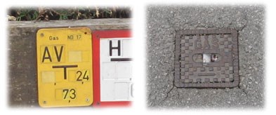
Unter den Straßen der Stadt verbirgt sich ein Netz von Gasleitungen, die die Häuser mit dem fossilen Brennstoff versorgen. Erkennbar sind die Ventile und Verzweigungen an den Deckeln im Asphalt oder den entsprechenden Hinweisschildern.
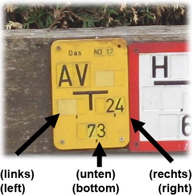
Die großen Buchstaben oben auf den Schildern (siehe Bild weiter unten) geben den Typ der bezeichneten Straßeneinbaute an. Die kleinen Felder rechts daneben sind für die Nummer der Straßeneinbaute vorgesehen, werden aber teilweise nicht benutzt. Darunter befindet sich dann jeweils der Abstand zum entsprechenden Deckel nach links, rechts und hinten gemessen in Metern (vom Fußpunkt des Schildes aus).
Dieser Multi führt euch auf eine kleine Runde (ca. 800 m) durch die Lohbachsiedlung. Auf dem Weg zum Cachebehälter werdet ihr an einigen solchen Hinweisschildern vorbeikommen, wobei euch gewisse Schilder davon jeweils den Weg leiten werden. Denkt auch daran auf dem Weg die entsprechenden Variablen zu notieren, da ihr diese dann für die Berechnung der jeweils nächsten Station und der Cachelocation benötigt.
Achtung
- Es sind nur die gelben Hinweisschilder für Gasleitungen zu beachten. Die blauen (Trinkwasser) und rot/weißen (Hydranten) Schilder, die oft am selben Ort angebracht sind, könnt ihr ignorieren.
- Die abzulesenden Werte (links), (unten) oder (rechts) sind jeweils die Entfernungsangaben auf den Schildern. (Siehe Bild)
- Die Kommas der Zahlen sind zu ignorieren (3,5 wird also zu 35; 7, wird zu 70).
- Ein Taschenrechner (oder ein Rechner am Notebook/Handy) erleichtert die Sache ungemein.
- Bedenke: Punktrechnung vor Strichrechnung.
Wegpunkte
Start (Header Koordinaten): N 47° 15.870 E 011° 21.353
a = (unten) + 63
Stage 1: N 47° 15.(899 + a) E 011° 21.(560 - 2 * a)
rechtes Schild
b = (unten)
Stage 2: N 47° 15.(723 + 3 * a - 2 * b) E 011° 21.(54 + b * b)
c = (links)
Stage 3: N 47° 15.(743 + a + b + c) E 011° 21.(1099 - b * c)
d = (unten)
Stage 4: N 47° 15.(756 + b * d) E 011° 21.(260 + b - c + d)
e = (rechts)
Final (Dose): N 47° 15.(739 + a + b - c - d + 8 * e) E 011° 21.(368 - d * e)
Die Dose
Es handelt sich um ein ca. 7 cm langes Röhrchen mit ca. 2 cm Durchmesser. Bitte das Röhrchen wieder ordentlich verstauen, damit man es nicht schon von weitem sieht - d.h. wieder links dahinter ganz bis zum Anschlag hineinschieben. Beim Heben und Zurücklegen des Caches bitte gut auf Muggels achten, weil der Cache von allen Seiten gut einsehbar ist.

 English:
General
Below the roads of the city there is a net of gas lines, which provide the households with the fossil fuel. The valves and junctions can be recognized by looking at manhole covers in the pavement or the corresponding gas line signs.
The big letters on top (see picture above) show the type of the designated device. The small fields right next to it are used to identify the device, but are sometimes not populated. Below this, the sign shows the distance to the hydrant measured to the left, right and backwards in meters.
This multi-cache will take you on a short tour (approx 800 m; 0.5 mi) through the Lohbachsiedlung. On your way you'll pass some of those hydrant signs - a few of them will guide you. Remember to note down the asked variables, in order to get to the next stage and finally calculate the location of the cache.
Attention
- Just the yellow hydrant signs are to be considered. Ignore the blue (drinking water) and red/white (hydrant) signs which are often mounted next to each other.
- The values (left), (bottom) or (right) to read from the signs correspond to the distances displayed on the signs. (see picture above)
- Decimal points (commas) are to be ignored (i.e. 3,5 is read as 35; 7, is read as 70).
- A calculator (-application) may come in handy.
- Remember: multiplication before addition/subtraction.
Stages
Start (Header Coordinates): N 47° 15.870 E 011° 21.353
a = (bottom) + 63
Stage 1: N 47° 15.(899 + a) E 011° 21.(560 - 2 * a)
right sign
b = (bottom)
Stage 2: N 47° 15.(723 + 3 * a - 2 * b) E 011° 21.(54 + b * b)
c = (left)
Stage 3: N 47° 15.(743 + a + b + c) E 011° 21.(1099 - b * c)
d = (bottom)
Stage 4: N 47° 15.(756 + b * d) E 011° 21.(260 + b - c + d)
e = (right)
Final (Container): N 47° 15.(739 + a + b - c - d + 8 * e) E 011° 21.(368 - d * e)
The cache
The container is a 7 cm (3 in) long tube with a diameter of 2 cm (1 in). Once found, please place the container right where you found it, so that it can't be seen easily - this means pushing it all the way back behind the left side. Exercise caution when grabbing and returning the cache, because the hideout is quite exposed and can easily be observed by Muggles.