EL CABR!TO
- Parada de los Roques -
LAS LOMADAS DEL SUR
Curvas moldeadas durantemilliones de anos
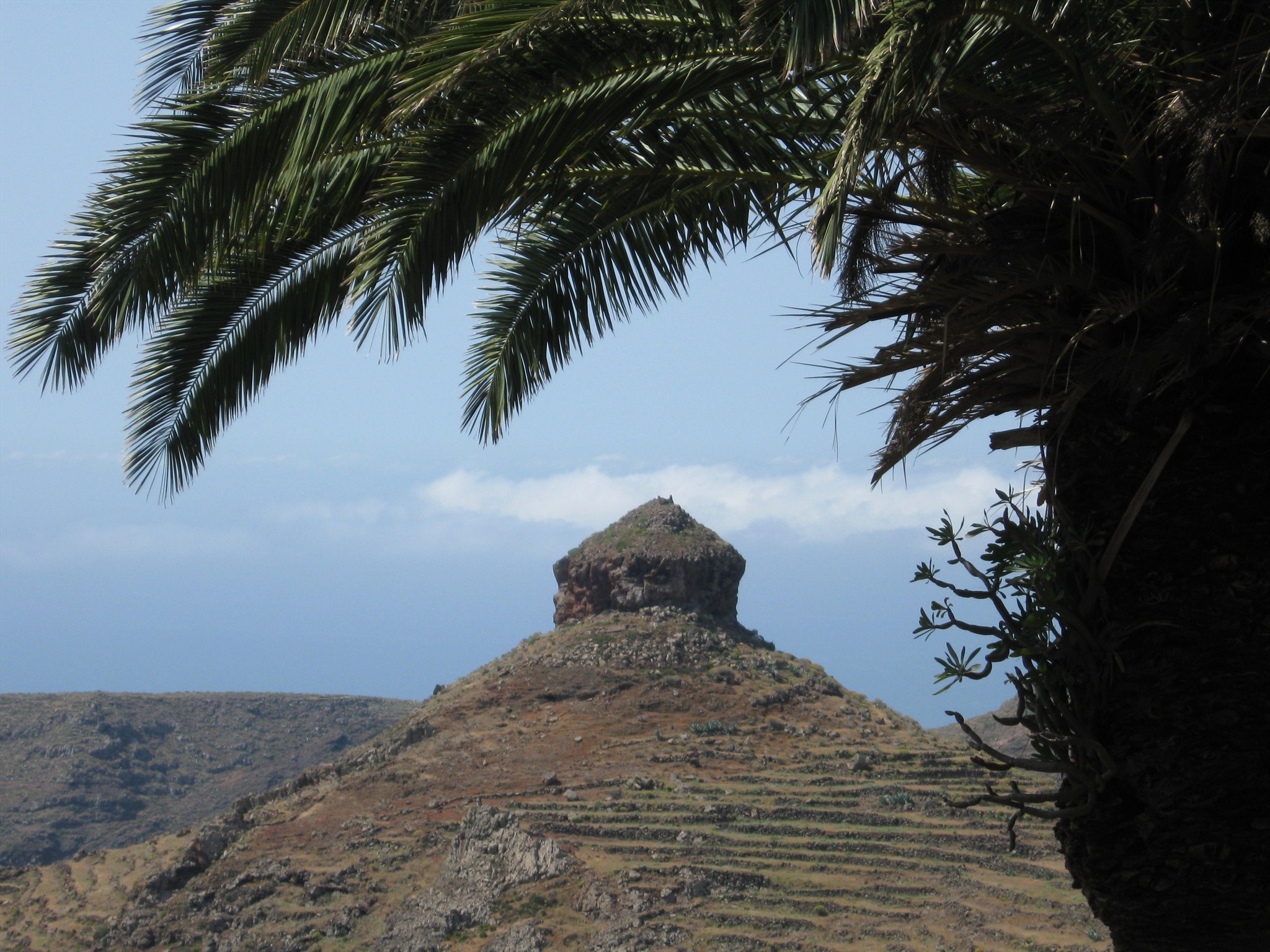
Estás contemplando uno de los Espacios Naturales Protegidos de La Gomera: el Monumento Natural del Cabrito. Este espacio recibe su nombre de la desembocadura del barranco Juan Vera. Destaca por su relieve abrupto, y por ser representativo de la vertiente sur, formando lomadas de cumbre a costa, que en muchos puntos están coronadas por roques de formas singulares.
Este paisaje es el producto de una ajetreada historia geológica que, según los expertos, se remonta, hasta hace unos 10 milliones de anos. Desde entonces, la erosión ha ido transformando la superficie, desgastando laderas y montanas, labrando barrancos y recortando costas. Además, La Gomera es la isla del archipiélago Canario que lleva más tiempo dormida: todo parece indicar que hace algo más de 2 milliones de anos que no tiene lugar ninguna erupción volcánica. Durante este tiempo, la lluvia y el viento han ido desgastando las zonas menos residentes a estos agentes ero-
sivos, marcando cada vez más los desniveles tan pronunciados que hoy puedes ver en toda la isla.
Los roques que contemplas desde aquí están formados por materiales que han resistído mejor la erosión. Destacan el del Sombrero, el roque Blanco, el de García, y el de Magro. Junto a este último puedes ver el caserío del mismo nombre, Magro, en el que hoy en día ya no vive nadie.
. . . preguntas abajo!
THE SOUTHERN HILLS
Curves fashioned over millions of years
You are contemplating one of La Gomera`s protected natural areas: El Cabrito Natural Monument, located at the mouth of Juan Vera ravine. The precipitous relief is typical for the soutern slopes that plunge from the summit to the sea and are often capped by roques, peculiar rock formations.
This landscape is the result of frantic geological activity that, according to experts, stretches back some 10 million years. Since then, erosion has painstakingly transformed the surface, grinding down hillsides and mountains, carving out ravines and chippingaway at the coastline. La Gomera is also the Canary Island that has long lain dormant. Everything appears to indicate that there has been no vulcanic eruption for over 2 million years. During this time, the rain and wind have worn away the least resistant areas, gradually revealing the hugely uneven terrain now visible all over the island.
The roques you can see from here are made of materials that have successfully resisted erosion, the most outstanding being El Sombrero, Roque Blanco, Roque de García and Roque de Magro. The now abandoned hamlet of Magro is located at the foot of Roque de Magro.
. . . questions below!
DIE HÜGEL DES SÜDENS
Über Millionen von Jahren geformte Kurven
An dieser Stelle gibt es eine von LaGomeras geschützten Naturgebieten zu sehen: das "El Cabrito" Naturdenkmal, welches nach der Mündung der Schlucht Juan Vera benannt ist. Die schroffen Reliefe sind bekannt für ihr zerklüftetes Gelände, deren Südhänge von den Gipfeln zum Meer verlaufen und die immer wieder von den eigentümlichen Felsformationen, den Roques unterbrochen werden.
Diese Landschaft ist das Ergebnis einer langen, geologischen Aktivität, die nach Meinung von Experten einige 10 Millionen Jahre zurück reicht. Seitdem haben Erosionen die Oberfläche nachhaltig verändert: Hügel und Berge wurden abgeschliffen oder ausgehöhlt,Schluchten ausgekerbt und zu denKüsten abgesenkt. La Gomera ist auch die Kanarische Insel, auf der die Erosionen am längsten ruhen. Alles deutet darauf hin, dass es seitüber 2 Millionen Jahren keinen Vulkanausbruch mehr gegeben hat. Während dieser Zeit haben Regen und Wind die am wenigsten resistenten Bereiche abgetragen, wodurch die äußerst unebene, hügelige Landschaft allmählich auf der gesamten Insel sichtbar wurde.
Die Roques die man von hier aus sehen kann, sind aus Gestein entstanden, welches erfolgreich der Erosion widerstanden hat. Herausragend dabei die Felsen El Sombrero, Roque Blanco, Roque de García und Roque de Magro. Der verlassene Weiler Magro befindet sich jetzt am Fuße des Roque de Magro.
. . . die Fragen stehen weiter unten!
Las preguntas:
1. ¿Como se llama este roque en las fotografías?
2. ¡Sondea de su ubicación en el roque García! ¿Cuantos grados son en esta dirección?
3. ¿Como se llama el barranco delante estes roques especiales?
4. En el lado opuesto de la carretera se pueden ver los roques "desde el interior". ¿Qué colores tiene?
Debes iniciar sesión para este earthcache inmediatamente. Envíame las respuestas via mi cuenta de GC.com.
Si algo está mal, me levanto.
The questions:
1. What`s the name of the roque, you can see on the photos?
2. Get a fix on the roque Garcia from the coordinates. What`s the number of degrees?
3. How is the barranco called, that is located in front of these special roques?
4. On the opposite side oft the street, you can see the "inner side" of the roques. Howe many colours has it? Which ones?
You may log this earthcache imideately. Send me the answers via my GC-account!
If something is wrong, I will contact you.
Die Fragen:
1. Wie lautet der Name des Felsens, der auf den Fotos zu sehen ist?
2. Peile von deinem Standort auf den Roque Garcia. Wieviel Grad sind es in dieser Richtung?
3. Wie ist der Name der Schlucht (barranco), die vor diesen besonderen Felsen liegt?
4. Auf der gegenüberliegenden Seite der Straße sieht man den Felsen "von innen". Welche Farben hat er?
Du darfst den Earthcache sofort loggen. Sende mir die Antworten an meinen GC-Account!
Wenn etwas nicht stimmt, melde ich mich.