The adjacent geographical areas of the chalky hills of the Chilterns and the clay plains occupying much of the rest of Buckinghamshire and Oxfordshire to the north-west offer a contrast in geology, soils and landscape. From the above coordinates you are placed well to view this contrast.
Leonardo da Vinci said, "We know more of the movement of celestial bodies than about the soil underfoot". This is still true.
The rocks comprising the Chilterns were laid down one above the other mainly in marine environments, but since then tectonic forces have brought them to the surface and caused the layers to tilt towards the south-east. This means that as you travel from Aylesbury to London via the Chilterns the rocks you travel over are progressively younger than those at the start of the journey. This uplift and folding was followed by a period of erosion to give the present subdued topography. The hardness of each type of rock also determines how easily it was eroded, so hard rocks tend to stick up as hills (the Chilterns), and soft rocks erode down into valleys.
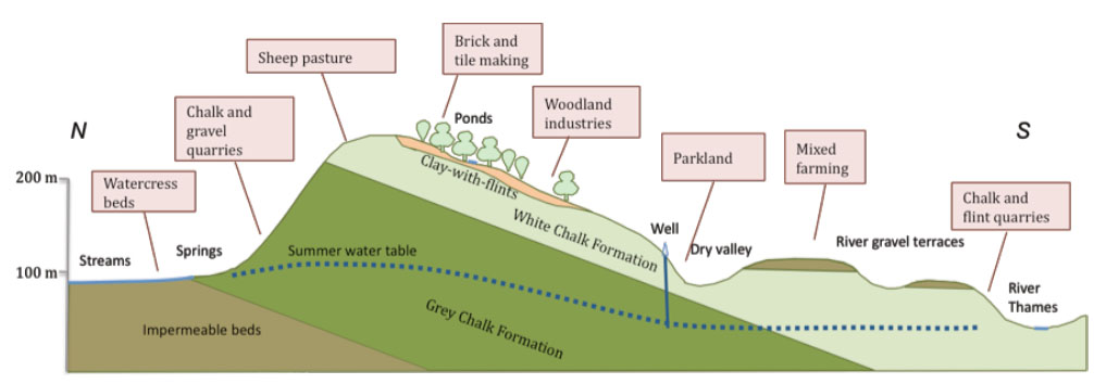
The type of rock determines many of the surface features. For instance, soil produced by Greensand clay (in Aylesbury Vale) is very fertile so we see agriculture dominating the land use. In areas overlying clays (which are impermeable) there are rivers and streams, e.g. the River Thames in South Bucks, the River Thame and the River Ouzel in Aylesbury Vale. In areas of chalk (which is permeable because it is fractured and jointed) there is no running surface water.
Clay minerals are typically formed over long periods of time by the gradual chemical weathering of rocks. Clay deposits may be formed in place as residual deposits in soil, but thick deposits usually are formed as the result of a secondary sedimentary deposition process after they have been eroded and transported from their original location of formation. Primary clays, also known as kaolins, are located at the site of formation. Secondary clay deposits have been moved by erosion and water from their primary location.
Silt is granular material of a size somewhere between sand and clay whose mineral origin is quartz and feldspar. Silt may occur as a soil or as suspended sediment (also known as suspended load) in a surface water body. It may also exist as soil deposited at the bottom of a water body.
Chalk is composed mostly of calcium carbonate with minor amounts of silt and clay. It is normally formed underwater, commonly on the sea bed, then consolidated and compressed during diagenesis into the form commonly seen today.
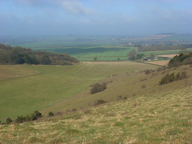
Chalk has greater resistance to weathering and slumping than the clays with which it is usually associated, thus forming tall steep cliffs where chalk ridges meet the sea. Chalk hills, known as chalk downland, usually form where bands of chalk reach the surface at an angle, so forming a scarp slope. Because chalk is porous it can hold a large volume of ground water, providing a natural reservoir that releases water slowly through dry seasons.
Aston Rowant Nature Reserve to the south of the page coordinates is a Geological site of special scientific interest.
To validate your find pleae e-mail me answers to the following questions,
1. With the hills to your right, descibe the landscape from left to right covering 180 degrees.
2. Where about on the cross-section above are you standing?
3. Examine the the ground beneath your feet. Describe the soil? Does this confirm where you are standing from the informatin above and why?
Feel free to upload a photo of yourself with any part of the hills in the background.
Please include with your e-mail, your caching name (e.g. metal-bijou) and your email address.
Don't worry about waiting for a reply before you log, in the very unlikely event that your answer is wrong I'll let you know so you can revise your answer or turn your smiley to a note.
 The most exciting way to learn about the Earth and its processes is to get into the outdoors and experience it first-hand. Visiting an Earthcache is a great outdoor activity the whole family can enjoy. An Earthcache is a special place that people can visit to learn about a unique geoscience feature or aspect of our Earth. Earthcaches include a set of educational notes and the details about where to find the location (latitude and longitude). Visitors to Earthcaches can see how our planet has been shaped by geological processes, how we manage the resources and how scientists gather evidence to learn about the Earth. To find out more click HERE.