BALLACHULISH BRIDGE
There is ample parking at the Hotel at either end of the bridge. At the Southern end is the Ballachulish Hotel on the A824 Oban road; actually under the bridge.(reccomended) Alternatively the Kinlochleven Hotel on the North end of the bridge. It is worth visiting here anyway and walking into the bay behind for great views.
Seldom do you come across a cache location that not only provides an enormous amount of geological interest but is also intertwined with a vast and varied quantity of informative historical, ecological and geological interest. So much so that there is sufficient of interest to provide the enquiring cacher with much time in the area.
Indeed I lived in a house below the raised beach adjacent to the bridge for many years and it would be remiss of me not to give you the fellow geocacher an indication of just some of the local points of interest. This platform is not the place to go into the enormous amount of flora and fauna in the area but suffice to say that it is outstanding and has the potential to provide you with an endless amount of interest, like this view from my kitchen window and dining room.
CLICK THE THUMBNAIL to enlarge in a seperate window with information about that locations in the Ballachulish & Glencoe 1 picture below.
A_____B______C_____D_____E_____F____


ARCHAEOLOGICAL AND HISTORICAL SITES OF GREAT INTEREST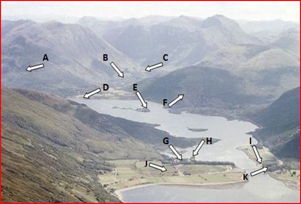
G__H_____I____J__K_____L


Films that have been partially shot in the local area include;1975 movie, "Monty Python and the Holy Grail" 2007 movie, "Harry Potter and the Order of the Phoenix" 2002 movie, "Harry Potter and the Chamber of Secrets" Braveheart (1995) Highlander (1986) Rob Roy (1995)
No better way to spend a day than in glorious sunshine along the shoreline at Onich, nr Glencoe looking at metamorphosed Lower Dalradian sediments: slates, quartzite and phyllite of the Ballachulish subgroup in the Appin Group; classic geology, but don’t hang around waiting for the sunny day; you could be there a while.
View looking east from Onich over the Ballachulish Bridge along Loch Leven, Highland Region. Glen Coe Quartzite showing corrie wall. Loch Leven is a glacially overdeepened rock basin.
SITES RICH IN EARTH SCIENCE OF WORLDWIDE INTEREST

The Pap of Glencoe, the prominent crags in left background is formed of Dalradian Supergroup Glen Coe Quartzite while the lower area on the opposite side of the valley is formed of Ballachulish Limestone. The Pap of Glencoe overlooks Loch Leven at the mouth of Glen Coe. There are a number of breast-shaped peaks in Scotland, and all are called paps, although the Pap of Glencoe is also called Sgurr na Cíche. The various paps of Scotland might be classed as a variety of mimetoliths, just like great stone faces are.
A well-developed corrie backwall is visible on Bidean nam Bian (right-hand background) within the lavas of the Glencoe Cauldron Subsidence. The flat area by the Ballachulish Bridge has been interpreted as a glacial outwash fan formed at a limit of the Loch Leven glacier.
Relative sea level fell following the final disappearance of the glaciers to be followed by a marine transgression which culminated at about 6000 and 6800 BP. This transgression formed the Flandrian raised beaches.
Overdeepening is a characteristic of basins and valleys eroded by glaciers. An overdeepened valley profile is often eroded to depths which are hundreds of meters below the deepest continuous line (the thalweg) along a valley or watercourse. This phenomenon is observed under modern day glaciers, in salt-water fjords and fresh-water lakes remaining after glaciers melt, as well as in tunnel valleys which are partially or totally filled with sediment. When the channel produced by a glacier is filled with debris, the subsurface geomorphic structure is found to be erosionally cut into bedrock and subsequently filled by sediments.
These overdeepened cuts into bedrock structures can reach a depth of several hundred meters below the present valley floor as is the case here in Kinlochleven. The large flat areas by the bridge are extensive gravel deposits and are a fluvioglacial outwash fan. It marks a contemporaneous halt in the retreat of the valley glacier which occupied the Loch. It has an outward sloping surface characteristic of an outwash fan and the inner steeper surface is considered to represent the original ice-contact slope. This is a sand/gravel bar, the result of fluvioglacial sedimentation by outwash streams from a melting glacier.
View from Onich above shows, Loch Linnhe, looking south towards Beinn a' Bheithir, Inverness-shire. Gravel platform of the Flandrian '25 ft.' raised beach fringing the loch. The Glencoe hills can be seen in the background. The raised beach can be seen in the centre, fringing the loch and on the wide platform at Ballachulish in the distance. The Glencoe hills form a major Caledonian Orogeny igneous intrusive complex called a cauldron subsidence.
SEDIMENTARY
Sedimentary rocks are types of rock that are formed by the deposition of material at the Earth's surface and within bodies of water. Sedimentation is the collective name for processes that cause mineral and/or organic particles (detritus) to settle and accumulate or minerals to precipitate from a solution.
Particles that form a sedimentary rock by accumulating are called sediment. Before being deposited, sediment was formed by weathering and erosion in a source area, and then transported to the place of deposition by water, wind, mass movement or glaciers which are called agents of denudation.
Rocks are the record, set in stone, of how the earth formed. The clues are all around you. You just need to learn the language and soon you’ll be reading the pages of earth’s history in the rocks that surround you…anywhere you go!
A very limited amount of Sedimentary Rock has been found in the area however the following are evident..
(metasediment is sediment or sedimentary rock which shows evidence of metamorphism.)Changing from one form to another through a process of heat or pressure or both.
Metasedementary rocks found in the Glen Coe area
Top of Sequence
8. Bedded breccia often resembling conglomerate, with fragments of quartzite,micaceous schists, and some felsite-all in a matrix of gritty sandstone.
7. Red shales with cornstones. (3.5m)
6. Purple shales. (1m)
5. Greenish and black shales, showing alternations of coarser and more sandy layers with finer graded beds. (3m)
4. Conglomerate, with angular and subangular boulders of quartzite (Eilde Quartzite?) and quartzose schists (Eilde Flags) in a green sandy matrix. (6m)
3. Green shales, some red, and angular beds of conglomerate. (5m)
2. Fine greenish breccia containing quartzite fragments. (0.5m)
1. Dalradian quartzite, much shattered at the surface.
Bottom of sequence
.
METAMORPHIC
Metamorphic rocks arise from the transformation of existing rock types, in a process called metamorphism, which means "change in form". The original rock (protolith) is subjected to heat and pressure, (temperatures greater than 150 to 200 °C and pressures of 1500 bars[1]) causing profound physical and/or chemical change. The protolith may be sedimentary rock, igneous rock or another older metamorphic rock.
Metamorphic rocks make up a large part of the Earth's crust and are classified by texture and by chemical and mineral assemblage (metamorphic facies). They may be formed simply by being deep beneath the Earth's surface, subjected to high temperatures and the great pressure of the rock layers above it. They can form from tectonic processes such as continental collisions, which cause horizontal pressure, friction and distortion.
They are also formed when rock is heated up by the intrusion of hot molten rock called magma from the Earth's interior. The study of metamorphic rocks (now exposed at the Earth's surface following erosion and uplift) provides information about the temperatures and pressures that occur at great depths within the Earth's crust. Some examples of metamorphic rocks are gneiss, slate, marble, schist, and quartzite.

IGNEOUS & METAMORPHIC
Igneous rock (derived from the Latin word igneus meaning of fire, from ignis meaning fire) is one of the three main rock types, the others being sedimentary and metamorphic rock. Igneous rock is formed through the cooling and solidification of magma or lava. Igneous rock may form with or without crystallization, either below the surface as intrusive (plutonic) rocks or on the surface as extrusive (volcanic) rocks.
This magma can be derived from partial melts of pre-existing rocks in either a planet's mantle or crust. Typically, the melting is caused by one or more of three processes: an increase in temperature, a decrease in pressure, or a change in composition. Over 700 types of igneous rocks have been described, most of them having formed beneath the surface of Earth's crust. These have diverse properties, depending on their composition and how they were formed.
All rocks begin as igneous rocks. Before rocks can be transformed by sedimentation and weathering or metamorphosed by the heat and pressure of plate tectonics they must first be cooled from the intense heat of the mantle. Whether they are formed from plutonic rocks deep within the crust of the earth or extruded onto the surface of the earth by volcanoes all rocks have a fiery beginning as igneous rocks.

Your Earthcaching tasks are as follows
1) Using your GPS calculate the actual height of the Flandrian Raised Beach at, N56 41.475 W005 10.955
2)What is built on top of the Flandrian raised beach and why do you think that was.
3).As detailed above, at the South end of the bridge is a monument to an historical event. (3a)What type of rock is on top of the monument. (3b)what Salm was being sung and (3c)how high was the ladder he climbed ? (Information on the Sign).
4)Optional task: We all like to prove the integrity of our claim so a photo of you or your GPS on the pebble beach would be great. Careful not to give the game away.
Send the answers to 1-4 (a-c) in an email to the cache owner via his profile with the heading Ballachulish.
PLEASE do not post the answers in your log
I would really like it if you could do this to prove that you have actually visited and I enjoy seeing caching photos in my listings.
Cachers can log the cache before receiving my confirmation email as any logs from cachers who haven't sent the answers will be quietly deleted!.
You must carry out these educational tasks as required by the Earthcaching organisation as a condition of logging the cache. Logs that do not adhere to these guidelines will be deleted without notification. See www.earthcache.org.
Refences:
Scottishgeology
regional-geology/grampian/glencoe/
Scottishgeology.com
jncc.defra.gov
mapapps.bgs.
geoscenic geograph.org.
lochabergeopark