Stonehenge bezeichnet Grabenanlagen, die von einer Megalithstruktur umgeben wird,
die wiederum aus mehreren Steinkreisen besteht. Die beeindruckensten Steinkreise sind zum einen ein äußerer Kreis bestehend aus Pfeilersteinen von Decksteinen überbrückt, zum anderen eine innere hufeisenförmige Struktur.
Um die geheimnisvollen Kultstätten ranken sich viele Sagen und Legenden.
Lange wurden die gigantischen Bauwerke den Druiden zugeschrieben. Um die geheimnisvollen Anlagen Stonehenge und deren Entstehungen ranken sich viele Legenden
Sage um den Fersenstein in England
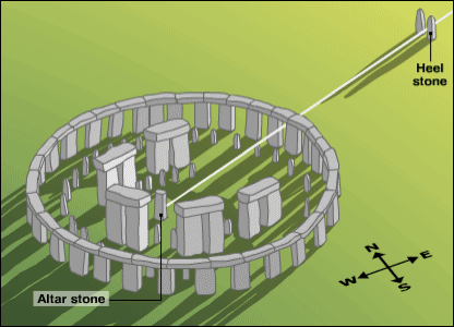
Der Fersenstein ("Heel Stone") wurde früher einmal Friar's Hell ("Mönchsferse") genannt,
in Ahnlehnung an eine Sage aus dem 17. Jahrhundert. Dieser Sage nach kaufte der Teufel die Steine bei einer Frau in Irland und brachte sie zur Salisbury Plain.
Einer dieser Steine fiel dem Teufel jedoch in den Fluss Avon, die restlichen Steine legte er in der Ebene ab. Er schrie: "Niemand wird je erfahren, wie diese Steine hierher kamen", darauf antwortete ihm ein Mönch: "Das glaubst aber auch nur du!". Daraufhin warf der Teufel mit einem der Steine nach dem Mönch und traf ihn an der Ferse. Der Stein steckte nun im Boden fest und kam so zu seinem Namen.
Die letzten Reste von der Grabanlage in Österreich liegen am Ufer der Alm. Es sind nur mehr ein paar kleinere Steine übergeblieben - man vermutet, dass die großen fehlenden Steine vom Fluss langsam abgetragen wurden!
Um an die Sehenswürdigkeit zu gelangen, kannst du direkt bei dem roten Schranken, Forststrasse zum Kraftwerk Harresau
parken N 48° 01.730 E 013° 55.356 (ca. 6 min. von der Autobahnabfahrt Vorchdorf entfernt)
Natürlich gehört an so einen Ort ein Cache! Also …
…gehe die Forststraße entlang, bis runter zur Alm vorbei am Kraftwerk, immer entlang der Alm.
Nach ~400 Meter Wanderung wirst du die Grabanlage endecken !
Der Cache 13x9x7 cm liegt bei N 48 01.644 E 013 55.678
Erstbefüllung : Erstfinderurkunde, Trackable Scuba Dive Flipper, 2 Karten, Coin, Schlüsselanhänger,
Der Weg ist wintertauglich (nicht geräumt) und geeignet für Kinder
Über viele Fotos und Kommentare freuen wir uns ;-)
Lg _TomSayer mit Familie
TIPP : GC1B9YY ▼ Die verlorene Welt Multi-cache ist in der Nähe !

Spoiler
Dose :-)
*******************************************
************ *******************************
*******************************************
A nice and short walk next to the Alm! Starting from the parking area it is not the shortest route but the most beautiful one! Estimated time for the round-trip is 15 minutes. Stonehenge describes grave plants, which is surrounded by a Megalith structure which in turn consists of several stone circles. The most impressive stone circles are on the one hand an outer circle consisting of pillar stones bridged by capstones, on the other hand an inner horseshoe-shaped structure. Many myths and legends exist around the mysterious places of worship. For a long time the gigantic monuments were attributed to the Druids. Many legends exist about the mysterious Stonehenge site and their formation. Legend of the Heelstone in England The ‘Heel Stone’ was once called ‘Friar's Heel’ following a legend from the 17th Century. According to this legend the devil bought the stones from a woman in Ireland and brought them to Salisbury Plain. But one of these stones was dropped by the devil into the River Avon, the rest of the stones he put on the plain. He shouted: "No one will ever know how these stones came here". A monk answered on it: "You can only think that!" Then the devil threw one of the stones at the monk and hit him on the heel. Now the stone stuck firmly in the ground and in so doing came to his name. The last remains of the grave site in Austria are on the banks of the Alm. There are only a few small stones left – it is assumed that the big missing pieces were worn out from the river slowly! To get to the sight, you can park directly at the red barrier, forest road to the power station Harresau. N 48 ° 01 730 55 356 E 013 ° (about 6 min. away from the motorway exit Vorchdorf) Of course, to such a place belongs a cache! So.... ….walk along the forest road, down to the river past the power station, always along the Alm- After ~ 400 meter walk you will discover the grave site! The cache is 13x9x7 cm N 48 01 644 E 013 55 678 Initial Treatment: Firstfindercertificate, Trackable Scuba Dive pinball, 2 cards, coin, key chain, The trail is suitable for winter (not cleared) and suitable for children We are looking forward to many photos and comments ;-) Lg Thomas with family