LOCAL INFORMATION
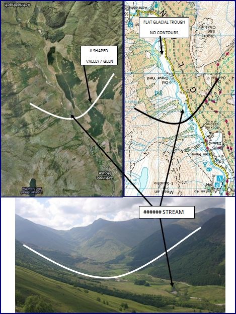
Glen Nevis is one of the most beautiful and spectacular glens in Scotland. It nestles at the foot of Ben Nevis and is easily accessible from Fort William on foot, by bike, car or bus. From the floor of Glen Nevis you can see some of the different rocks that make up the Highlands of Scotland, as well as dramatic evidence of sculpting by the huge Ice Age glaciers which once filled the glen.
All of Ben Nevis Estate lies within the Ben Nevis SSSI. It is of particular importance on account of its wide range of geological conditions, altitude and topography giving rise to a diversity of semi-natural and natural habitats from lowland woods to mountain cliffs and semi-permanent snow beds.
The site is of international and national importance for a range of upland habitats and nationally important for upland birds, insects, vascular plants, mosses, liverworts and lichens. It is also of national importance for geology; and for its woodlands with their associated mosses and liverworts.
Geology of Ben Nevis
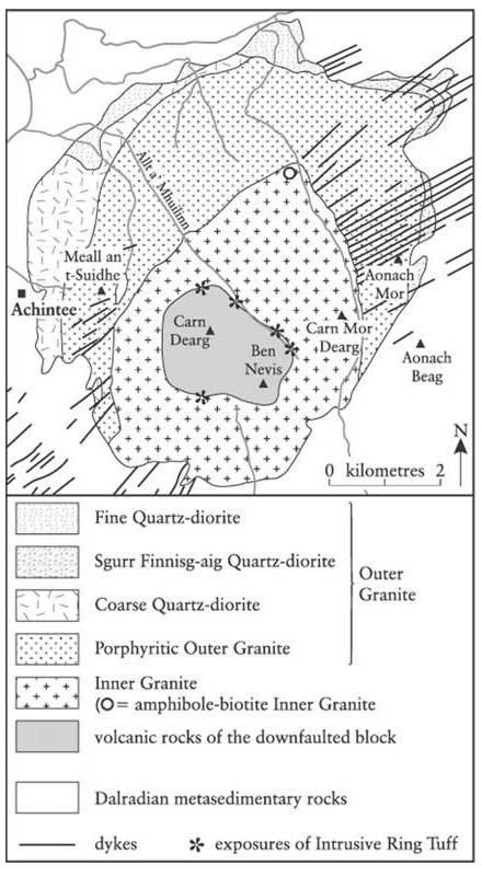
Ben Nevis consists mainly of igneous rock from the Devonian period (around 400 million years ago), intruded into the surrounding metamorphic schists during a period when Ben Nevis was part of an active and massive volcano; the intrusions take the form of a series of concentric ring dikes.
The innermost of these, known as the Inner Granite, constitutes the southern bulk of the mountain above Lochan Meall an t-Suidhe, and also the neighbouring ridge of Carn Mòr Dearg; Meall an t-Suidhe forms part of the Outer Granite, which is redder in colour.
The summit dome itself, together with the steep northern cliffs, are composed of andesite and basaltic lavas. The mountain has been extensively shaped by glaciation and although the last ice age saw ice several kilometers deep it was not enough to cover the Ben Nevis summit.
RIVER NEVIS
Roaring mill - A'Mhuileann roiceach The first stopping point lies 1km into the glen on the west bank of the River Nevis. Here you'll see some steeply inclined slabs of metamorphosed sandstone, known locally as the Eilde Flags. These were once sandy sediments on the edge of a great ocean and were created during the continental collisions that formed the Caledonian mountains. At about 700 million years old.
The Glen Nevis River Race is an extreme challenge involving participants navigating through the icy waters of a two-mile stretch of the River Nevis on an air-bed (Lilo). The intrepid adventurers begin by launching themselves off a small ledge on a rock face, plunging into the freezing waters of the River Nevis below.
The rules are clear participants have to follow the deepest course of the river through rocks and rapids, whilst negotiating major obstacles like the Gurgling Gorge, Dead Dog Pool, the Leg Breaker and the Lower Falls Leap; finishing in the calmer waters further down the glen.
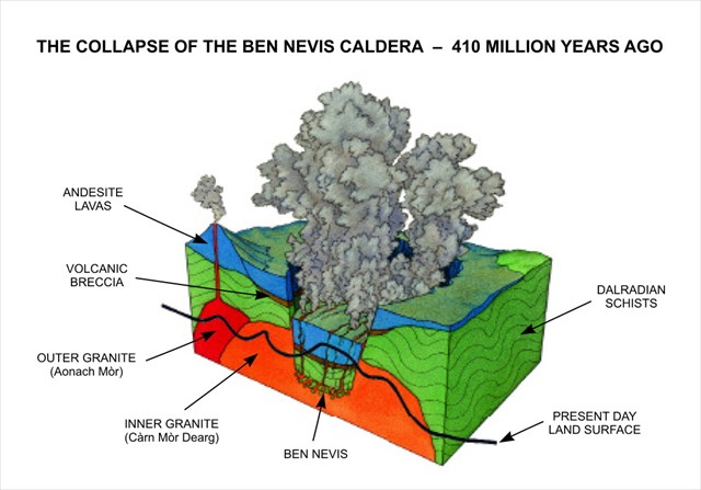
The igneous rocks formed when the Caledonian Mountains were created include some extraordinary collapse structures called calderas. The road through Glen Coe runs right across a deeply eroded ancient caldera. It is astonishing that the rocks now forming the summit of Ben Nevis collapsed more than 600m to form a similar caldera around 400 million years ago.
>
TASKS
Your Earthcaching tasks are as follows:
1) Observe the photo montage above, and what you see from the cache co-ordinates above, describe the type of valley down which River Nevis flows.
2) What is the geographical name for a body of water flowing down this type of valley/glen, and explain the reasoning behind this?
3) The Metamorphosed Sandstone rock at this point has a particular significance being about 700 million years old what is it?
4) Estimate the width at the narrowest end and the widest end of the constriction.
Send the answers to 1-4 in an email to the cache owner via his profile with the heading ROARING MILL.
Do not post the answers in your log.
Optional task:
We all like to prove the integrity of our claim so a photo of you or your GPS on the pebble beach would be great. Careful not to give the game away.
I would really like it if you could do this to prove that you have actually visited and I enjoy seeing caching photos in my listings.
Cachers can log the cache before receiving my confirmation email as any logs from cachers who haven't sent the answers will be quietly deleted!
You must carry out these educational tasks as required by the Earthcaching organisation as a condition of logging the cache. Logs that do not adhere to these guidelines will be deleted without notification.
See www.earthcache.org