This is 1 of 12 EarthCache sights in the SRWT. The first 100 to complete the trail will receive a geocoin commerating the SRWT, 60 of which are trackable. These will be available at the Mercer County Conservation District office Mon.- Fri. from 8 am to 4 pm after April 21st. We are located at 753 Greenville Road, Mercer, PA 16137. To learn more about this geoWatershed Trail, visit us by clicking here.
SHENANGO RIVER HISTORY (Mondok, 1990)
The Shenango River Basin is shared by the state of Ohio and the Commonwealth of Pennsylvania. The river and its tributaries drain 744 square miles of the Pennsylvania counties of Crawford, Lawrence, and Mercer and 285 square miles of the Ohio counties of Ashtabula , Mahoning, and Trumbull. The waters and its tributaries been used for transportation such as the Erie Extension Canal, watering livestock, and other household uses.
Prior to European settlement, the land area of the Shenango was inhabited by many indian tribes including the Seneca and the Delaware. The word Shenango itself comes from the Iroquoian word Shaningo meaning “beautiful one”.
The 75 mile long river begins in the marshes that are now part of Pymatuning Reservoir near Hartstown in Crawford County and eventually meets the Mahoning River near New Castle in Lawrence County.
ICE AGE INFLUENCES (Mondok, 1990)
The topography and soils in Pennsylvania and Ohio were shaped during the Ice Age that ended about 10, 000 years ago. Prior to this glacial epoch, the Shenango River flowed in a northerly direction to the Atlantic Ocean via the Great Lakes and St. Lawrence River. This dissected plateau was covered by glaciers; some were a mile thick in some places. Boulders, rocks, soil, sand, silt, and clay were carried with the glacial ice and deposited on glacial till, kame terraces, moraines, and eskers when the ice melts as the climate warmed. These deposits were so vast, that their ancient river valleys were filled, causing the flow from the Atlantic Ocean to the Gulf of Mexico.
WHAT IS A FEN?
A fen is a peat-forming wetland that receives its nutrients from sources other than precipitation; it usually comes from upslope sources through drainage of surrounding mineral soils and from groundwater movement. Unlike other types of wetlands, fens are usually alkaline; in other words they have a basic pH due to small amounts of dissolved limestone within it. Because of this unique feature, they are able to support much more diverse plant and animal communities (EPA, 2011).

This image portrays what a typical prairie fen looks like. There are actually three basic types of fens: prairie, deep muck, and forested.
PEAT BASICS
To put it simply, peat is the accumulation and fossilization of vegetative debris in wetlands over centuries. It is a dark fibrous material that is created in areas where decomposition fails to keep pace with the production of organic matter (Finlayson, M. and M. Moser, 1997).
So where did these wetlands come from? As stated previously, at one point, the areas within Ohio and Pennsylvania were once covered by glacial ices. As the glaciers retreated, the wetlands were developed from the changes in the topography of the land.
McCOY STATE NATURE PRESERVE-PYMATUNING CREEK FEN
The McCoy State Nature Preserve is a 215 acre area that was set aside by the Museum of Natural History as an area to be protected and allow limited access. This nature preserve houses the Pymatuning Creek Fen. The Pymatuning Creek Fen is host to many unusual northern plants called relict species that were left behind from the glacial ice front that receded thousands of years ago. One such species is the rare spreading globe flower. Not only does the fen provide homes for unique flora, it also provides a home for unique fauna as well. An endangered mollusk, the clubshell, is located in this fen as well as the brush-tipped emerald dragonfly (Cleveland Museum of Natural History, 2012). This fen is one of the many unique geological features within the Shenango River Watershed; Pymatuning Creek is one of the main tributaries that drains into the Shenango River at the Shenango River Lake.
COORDINATES TO PARKING AREA
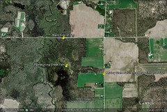
Because this is a state nature preserve, public access in not permitted without a permit. Therefore, please respect that and do not enter the McCoy State Nature Reserve. From the coordinate location, you will see part of the fen towards the south. Below is a map that showcases, the backside of the fen (which you will see), the main location of the fen, and the location of the McCoy State Nature Preserve sign. During certain times of the year, the Museum of Natural History schedules walks where you can actually have access to the preserve and see the main location of the fen. Check their adult field trip schedule for upcoming events. To access their website click here.
To view a larger version of this for better viewing, please visit this website by clicking here.
TO GET CREDIT FOR THIS CACHE:
Please be sure to send your answers to the following questions to jmccullough@mcc.co.mercer.pa.us in order to receive credit for this cache.
1. What are some signs that this is a wetlands area?
2. What type of soil seems to be in the area? Hint: Due to this soil, water tends to drain poorly, thus causing the wet area. This type of soil tends to ribbon when you rub it between your fingers.
3. Based off of the topographical map right before the logging requirements, what type of fen do you seem to be looking at (prairie, deep muck, or forested)? What type of fen does the main Pymatuning Creek Fen appear to be, based off the map?
References:
Cleveland Museum of Natural History. (2012). McCoy State Nature Preserve. Cleveland Museum of Natural History. Retrieved from: http://www.cmnh.org/site/Conservation/NaturalAreas/Map/McCoyNaturePreserve.aspx
Environmental Protection Agency. (2011). Fens. Water: Wetlands. Retrieved from: http://water.epa.gov/type/wetlands/fen.cfm
Finlayson, M. and M. Moser. (1997). Wetlands. International Waterfowl and Wetlands Research Bureau, vol 6, p. 7.
Mondok, J. (1990). The Shenango River. Shenango Riverscapes, 1-2.