
Sand – Geology at its finest!
East Surrey has a range of mineral deposits, localized and directly related to the region’s geology.
Fine sands are found locally in a narrow band called the Folkestone Formation or Folkestone Beds, part of the Lower Greensand running east/west, to the south of the North Downs and across the centre of Surrey.
Fullers’ Earth is also found nearby - where it occurs in the “Sandgate Formation”.
The different types of earth exposed in layers at the surface within the region are all of relatively young geological age (from the Cretaceous Period – 145.5m to 65.5 million years ago) and consist mainly of clays, sands, sandstones and chalk. North of here, the line of chalk of the North Downs forms the most distinctive geological feature in the area. South of here is the Sandstone of the Lower Greensand Group escarpment including Tilburstow Hill.
Between these two formations are the Gault and Upper and Lower Greensand Formations. There are numerous minor folds and faults across this area including the Folkestone Formation. The Folkstone Formation is the uppermost part of the Lower Greensand Group and consists of loosely consolidated quartzose sands, including deposits of clean, white silica sand. Often irregular bands of ferruginous (iron bearing) sandstone called carstone occur. This will have an orange or red colour showing the iron contained within the sands. Small pieces of the dark carstone were often historically inserted in the mortar joints of stone buildings – this was known as garneting.
Silica sand is so called because it has high silica content in the form of quartz. The pure white sands found here are amongst the purest in the country and have very low levels of iron oxide and alumina, making them particularly suitable for the manufacture of clear glass and sodium silicates. The main glass products produced from silica sand include colourless bottles and jars, flat glass, light bulbs and fluorescent tubes, TV and computer screens, and glass fibre. Some 65% of the sand extracted locally is low iron sand used in this way and the capacity of the area granted planning consent was just under 3 million tons in 2007. The total UK production of silica sand in 2007 was circa 5 million tons. The total capacity of the mine was expected to be over 500,000 tons per annum in 2010.
This sand is also used extensively in sports – in golf on greens for supporting rootstock growth, and in bunkers, in equestrian events as it doesn’t stain and provides good solid footing (hooving?) for the horses and riders. Most famously, the sand from here is being used in the 2012 Olympics. 2,274 tons of sand was delivered to Horse Guards Parade in July 2011 for the Beach Volleyball Venue, providing the base for a competition court, two warm-up courts and two training courts. It is also being used for some Equestrian events like show jumping and dressage. The area could still supply some 650,000 tons of this grade of sand under current planning consent in 2007.
So when watching the beach volleyball in the Olympics this summer please remember that the court and possibly the TV screen you are watching it on (unless you are lucky enough to have tickets!) were dependent on the sand nearby for your enjoyment of the event.
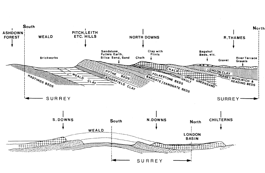
Fig: Idealised cross section of the geological strata in East Surrey (Surrey Minerals Plan).
To claim this cache, please answer the following questions and email me the answers via our email above. Please tick the box saying that you will allow your email address to be shown and responded to as it is much easier.
Q1: At the location look south east and you will see a layer of topsoil below the grassy ridge. At that point how deep do you think the topsoil is on top of the workings?
Q2: Follow the ridge along to the west and you will see an area with very little (almost no) topsoil. Why do you think that is? What colour is the sand to be found there and is it mainly silica or mainly iron bearing construction sand? (Orange sand will contain iron and white will be purer quartzose sand)
Q3: How deep do you estimate the seam of sand in the Folkstone Beds is from top to bottom where you can see it now?
Q4: Just for fun and not for the cache: if there is still over 3 million tons of sand available to be extracted in the area that you can see, how much do you think has already been taken out?
Source Material:
The Geology of Surrey – Surrey Minerals Plan November 2009 – Roger Hargreaves, Published by Surrey County Council
Transactions of the Geological Society of London – Dr Fitton on the Strata below the Chalk (1830)
Silica Sand – British Geological Survey Mineral Planning Factsheet – September 2009
A Study of Silica Sand Quality and End Uses in Surrey and Kent – For Surrey and Kent County Councils, by GWP Consultants - March 2010